Lighthouses of Northern Taiwan

Taiwan is a large island, nearly 400 km (250 mi) long, lying about 180 km (110 mi) off the coast of China. The island was claimed by the Chinese Empire in 1683 and some of its coastal regions at least were governed by China for more than 200 years. In 1895, following the first Sino-Japanese War, China ceded control of Taiwan to Japan. Japan governed the island until the end of the Second World War in 1945. While in power the Japanese constructed several lighthouses in Taiwan that remain active today. At the end of the Chinese Civil War in 1949 the collapse of Nationalist forces in mainland China led to a new governmental separation between Taiwan and the mainland, with the Nationalist government, the Republic of China (Zhōnghuá Mínguó, 中華民國), on Taiwan and the Communist government, the People's Republic of China, on the mainland. This separation continues to the present day.

For local government Taiwan is divided into 22 districts variously classified as special municipalities, cities, or counties. This page includes lighthouses of the north coast of Taiwan, including the special municipalities of Taoyuan and New Taipei and the city of Keelung.

Standard Chinese, often called Mandarin, is a primary language in Taiwan as it is on the mainland, but most residents also speak Taiwanese and there are several other indigenous languages on the island. The Chinese word for a lighthouse is dēngtǎ (灯塔). Jiao or chiao is a cape, dao, tao, yu, or hsu is an island, wan is a bay, and kang or gang is a harbor. Due to competing systems for transliterating Chinese into Latin characters, there are always several possible spellings for the names of places in China. The Wade-Giles system was in use in Taiwan for many years, but at the beginning of 2009 the Pinyin system used on the mainland became the standard in Taiwan as well. At the present time most place names in Taiwan are still known under their Wade-Giles spellings: Keelung rather than Jilong, for example, and Kaohsiung rather that Gaoxiong.

Lighthouses in Taiwan are operated by the Maritime and Port Bureau. The Bureau is carrying out a program to restore and develop the light stations as tourist attractions.

Special thanks to Felix Lin for comments on Taiwan lighthouses and permission to present his photos.

ARLHS numbers are from the ARLHS World List of Lights. TW numbers, if known, are from the Taiwan List of Lights. Admiralty numbers are from volume P of the Admiralty List of Lights & Fog Signals. U.S. NGA List numbers are from Publication 112.
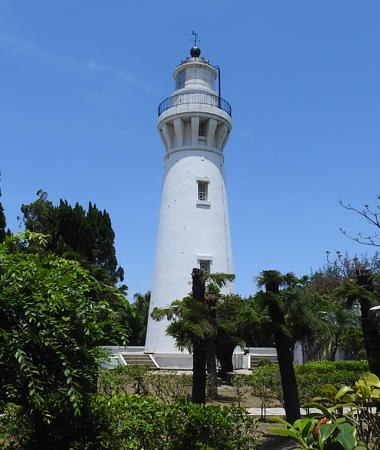


Baisajia Light, Guanyin, April 2021
photo copyright Felix Lin; used by permission

General Sources
Public Service - Lighthouse
Basic information on the lighthouses posted in English by the Maritime and Port Bureau.
Online List of Lights - Taiwan
Photos by various photographers posted by Alexander Trabas. Most of the Taiwan photos are by Felix Lin.
Lighthouses in Taiwan
Photos by various photographers available from Wikimedia.
World of Lighthouses - Taiwan
Photos by various photographers available from Lightphotos.net.
Lighthouses in Taiwan
Wikipedia checklist, useful for its romanized spellings of the lighthouse names.
Leuchttürme auf Briefmarken
Postage stamp images posted by Klaus Huelse.
Leuchttürme Chinas auf historischen Postkarten
Historic postcard images of Chinese lighthouses, also posted by Klaus Huelse.
Navionics Charts
Navigational chart for northern Taiwan.

Keelung Yu Light, New Taipei, June 2022
Google Maps photo by Hsing Miao
Taoyuan Municipality: Guanyin District Lighthouses
Taoyuan is a special municipality, formerly a county, located on the west edge of the Taipei metropolitan area. Rapidly growing, it has a population of about 2.25 million.

* Taoyuan Research Center
Date unknown. Active; focal plane about 30 m (98 ft); red light, pattern unknown. Mast on a square tower atop a 5-story research center building. Trabas has Lin's closeup photo and Google has a street view and a satellite view. Located about 1.5 km (1 mi) west of the Baisajia Lighthouse (next entry). Site open, tower closed. Admiralty P4661.98.
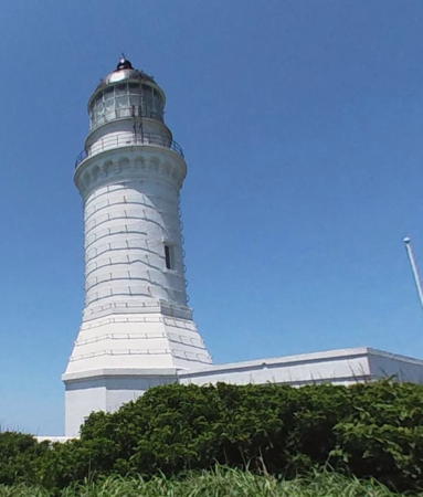
**** Baisajia (Baishajia, Paisha Chia, Pai-Sha Chia)
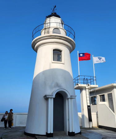
1902. Active; focal plane 37 m (121 ft); flash every 10 s, alternately red and white. 25 m (82 ft) round brick tower with lantern and gallery. Original 3rd order Fresnel lens in use. Lighthouse painted white, lantern dome black. A photo contributed by Lin is at the top of this page, Trabas has another of Lin's photo, Wikimedia has a 2011 photo, Shenhung Lin has a 2008 photo, Chengnan Wu has a photo, Huang Xiaowei has a closeup street view, and Google has a satellite view. This was the third lighthouse built in Taiwan under the Japanese administration. Originally it was 38 m (125 ft) in height, but the upper portion was destroyed during World War II. After the war, the tower was repaired to its present height. In March 2013 it was announced that the light station would be opened for tours starting in September. Located on a bluff above the coast in the Guanyin District. Site open, tower open daily except Monday year round. . ARLHS TAI-019; Admiralty P4662; NGA 13952.
 

Northern New Taipei Municipality (Danshui Area) Lighthouses
Taipei is the capital of Taiwan. New Taipei City (Xinbei Shi), formerly Taipei County, is a suburban municipality that includes the northern end of Taiwan except for the urban areas of Taipei and Keelung. Danshui (also spelled Tanshui and Tamsui) is a seaside district at the mouth of the Danshui River.

Linkou Power Plant North Breakwater
2018. Active; focal plane about 22 m (72 ft); green flash every 5 s. Approx. 18 m (59 ft) round bottle-shaped green concrete tower. Lin's photo is at right and Trabas has another photo by Lin but the tower is not shown in Google's satellite view. Located on the breakwater of the Linkou Power Plant in the Linkou District about 15 km (9 mi) west of Danshui. Site and tower closed. TW 10874; Admiralty P4663.18.
Hsia-ku-tzu
Date unknown. Active; focal plane about 45 m (148 ft); white light, 1.5 s on, 1.5 s off. 43 m (141 ft) square chimney, part of a waste incineration plant. The tower is white with a red-and-white checkered band near the top. Trabas has Lin's photo, a 2020 photo is available, and Google has a street view and a satellite view. Located across the expressway from Danshui Harbor. Admiralty P4663.25; NGA 13960.17.
Danshui South Breakwater (2)
Date unknown. Active; focal plane 19 m (61 ft); red flash every 5 s. 17 m (56 ft) round strongly conical concrete tower with gallery, painted red. Ricky Hwang has a closeup photo, Trabas has Lin's closeup photo, Xu Alun has a more distant view, and Google has a satellite view and a very distant street view from shore. This lighthouse replaced a light on a short pole. Located at the end of the south breakwater of the new Port of Taipei. Site status unknown. Admiralty P4663.3; NGA 13960.2.
Danshui North (Outer) Breakwater
Date unknown. Active; focal plane 18 m (59 ft); green flash every 5 s. 16 m (52 ft) round concrete tower with gallery, painted green. Erica Chan has a sunset photo, Xu Yongjing has a closeup photo, Trabas has Lin's photo, and Google has a satellite view. Located at the end of the outer breakwater of the new Port of Taipei. Site status unknown. Admiralty P4663.4; NGA 13960.1.
* Pa-Li
Date unknown. Active; focal plane about 23 m (75 ft); continuous red light. Light mounted atop a large 19 m (62 ft) round concrete block tower. Trabas has Lin's photo and Google has a street view and a satellite view. This is a leading light guiding vessels on the approach to the Danshui River. Located on Waziweh Street on the west side of the river mouth. Site open, tower closed. Admiralty P4664.5; NGA 13961.9.

Linkou Power Plant North Breakwater Light, New Taipei, 2021
photo copyright Felix Lin; used by permission
* Hui Wharf
Date unknown. Active; focal plane 14 m (46 ft); continuous red light. 13 m (43 ft) tapered square skeletal tower, painted white. Kevin Kung has a photo, Trabas has Lin's photo, and Google has a street view and a satellite view. The light guides passenger ferries crossing the harbor. Located in the Huanhe Road shopping district on the waterfront in downtown Danshui. Site open, tower closed. Admiralty P4666.5; NGA 13964.
* Danshui (Tanshui, Tan-Shui Kang) (3)
1970 (station established 1796). Active; focal plane 35 m (115 ft); white light, 2 s on, 6 s off. 33 m (108 ft) tapered square skeletal tower, painted white. A 2016 photo is available, Lightphotos.net has a good photo, Trabas has Lin's photo, Fu Hung Chun has a drone view, and Google has a street view and a satellite view. The 1796 lighthouse was a small square tower; it was replaced in 1888 by the front light of a range on a skeletal tower. Apparently both of these lighthouses were destroyed in World War II. Located on a promontory on the north side of the entrance to the Danshui River in Danshui. Site open, tower closed. . ARLHS TAI-029; Admiralty P4664; NGA 13960.
**** Fugueijiao (Fu-kuei Chiao, Fukwei Chiao, Cape Fukwei) (3)
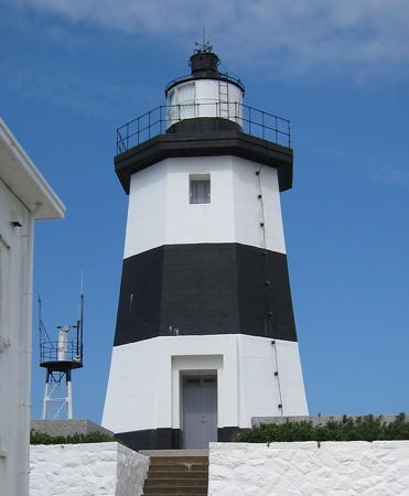
1968 (station established 1897). Active; focal plane 31 m (102 ft); two white flashes every 15 s. 14 m (46 ft) octagonal concrete tower with lantern and gallery, rising from a 1-story keeper's house. Lighthouse painted with black and white horizontal bands. Fog horn (blast every 30 s). Ken Marshall's photo is at right, Trabas has Lin's closeup photo, Brandan Hung has a 2021 photo, Lightphotos.net has a nice view, Wikimedia has a distant view, Huelse has a postage stamp image, Reggie Wu has a street view, and Google has a satellite view. In Milli Yeh's photo the fog horn tower stands beside the lighthouse. The original lighthouse, an octagonal cast iron tower prefabricated in Tokyo, was heavily damaged in World War II. It was dismantled in 1954 and replaced by a temporary steel skeletal tower. The present lighthouse is apparently a replica of the original lighthouse in concrete. In February 2015 the Bureau announced that the lighthouse would be renovated and opened to the public. Tours began in late August. A more complete restoration was carried out in 2018. Except for Pengjiayu this is Taiwan's northernmost lighthouse, located on a promontory in Shimen about 2 km (1.2 mi) north of Laomei. Site open, tower open daily except Monday year round. Site manager: North Coast and Guanyinshan National Scenic Area. . ARLHS TAI-008; Admiralty P4670; NGA 13592.

Fugueijiao (Fu-kuei Cape) Light, Shimen, January 2020
Flickr Creative Commons photo by Ken Marshall
* Yeliou (Yeh-Liu Pan-Tao)
1967. Active; focal plane 99 m (325 ft); white light, 3 s on, 7 s off. 12 m (36 ft) white concrete post supported by four curving legs. Tzu-leng Hung has a 2008 closeup photo, Trabas has Lin's closeup photo, Lightphotos.net has a closeup photo, a 2016 photo is available, Huelse has a postage stamp image, and Google has a satellite view. This unusual modern light was designed to resemble a candle stand. Visitors can admire the view from seats under the light tower, as seen in Sam Lim's 2016 street view. The area is famous for remarkable rock formations sculptured by wind and waves, and these rocks extend offshore as a very dangerous reef. Located at the tip of a narrow peninsula about 12 km (7.5 mi) northwest of Keelung. Accessible by a very scenic hiking trail. Site manager: Yehliu Special Scenic Area. . ARLHS TAI-036; Admiralty P4672; NGA 13596.

Pengjiayu Lighthouse
Pengjia (Peng Chia Hsu or Péngjiā Yǔ) is a small volcanic island located about 60 km (38 mi) northeast of the northern tip of Taiwan. The height of the volcano is listed as 165 m (541 ft). The island is uninhabited except for the staffs of the light station and a weather station and a small Army detachment that maintains Taiwan's sovereignty. There is also housing for visiting scientists. Older sources may refer to the island as Agincourt, the name given to it by Western navigators. The island is placed administratively under Keelung City.

Pengjiayu (Pangchia Yu, Peng Chia Hsu, Pen Chia Yu) (2)
1909 (station established 1897). Reactivated (inactive ?-1995); focal plane 146 m (479 ft); white flash every 15 s. 26 m (85 ft) round brick tower with lantern and gallery, mounted on an hexagonal pyramidal brick base and rising from a keeper's house. Original 1st order Fresnel lens, the only first order lens in use in Taiwan. Lighthouse painted white; the lantern dome is black. Iron bands have been placed around the tower to strengthen it against typhoons and earthquakes. A photo is at right, the lighthouse appears on a postage stamp, the Taipei Times has a 2002 article on longtime keeper Peng Hsing-shih, and Google has a street view and a satellite view. The lighthouse was repaired after being damaged by aerial strafing during World War II and again after being put out service by air attacks from the mainland. Site and tower closed; visits require permission of the military.ARLHS TAI-022; Admiralty P4690; NGA 13588.

Pengjiayu Light, Pengjiayu
Maritime and Port Bureau photo
 

Keelung (Jilong, Chilung) City: Keelung Harbor Lighthouses
Keelung is Taiwan's second largest seaport (after Kaohsiung). It forms part of the Taipei-Keelung metropolitan area, which has a total poulation of about 7 million; the population of Keelung City proper is about 375,000.
* Keelung Yu (Chilung Tao, Keelung Island)
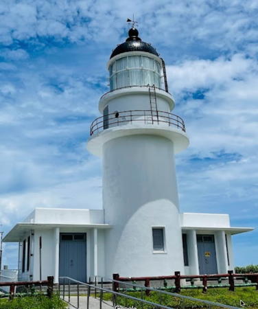
1980. Active; focal plane 189 m (620 ft); white flash every 5 s. 12 m (39 ft) octagonal concrete tower with gallery, rising from a square 1-story base. Lighthouse painted with black and white vertical stripes. Hsing Miao has the 2022 photo at the top of this page, Doug Nienhuis has a 2012 closeup, Trabas has Michael Boucher's photo, the lighthouse is seen in a view from the sea, Geocaching.com has a photo showing the trail to the lighthouse, Google has sea view and a street view, and Bing has a satellite view. This was the first Taiwanese lighthouse to operate under solar power. Located atop the Keelung Islet, a steep-sided island about 6 km (3.5 mi) northeast of Keelung harbor. The island is accessible by passenger ferry from Keelung and it is a popular but challenging climb up to the lighthouse. Site status unknown. . ARLHS TAI-005; Admiralty P4672.2; NGA 13600.
Keelung (Chilung) West Breakwater
Date unknown. Active; focal plane 16.5 m (54 ft); red flash every 3 s. 11 m (36 ft) 2-stage concrete tower, a round post mounted on a broad octagonal base. Entire lighthouse painted red. Trabas has Lin's photo, this light is on the left in Su Youkuan's photo of the harbor entrance, and Google has a satellite view. Located at the end of the west breakwater at the entrance to Keelung harbor. Site and tower closed. Admiralty P4676; NGA 13620.
Keelung (Chilung) West Inner Breakwater (Guanghua Tower)
1967. Active; focal plane 30 m (98 ft); continuous red light. 26 m (85 ft) round cylindrical concrete tower supporting a rotating café. Lighthouse painted blue with a red roof; the light is shown from a short post centered atop the tower. Gao Minlang has a 2022 photo, K.C. Chuang has a 2016 photo, Charlie Tai has a 2018 photo, Trabas has Lin's photo, Huelse also has a photo, and the red roof is conspicuous in a Google satellite view. This tower was built by the Keelung Harbour Bureau and used for corporate functions; in 2000 it was transferred to the Keelung City government and renovated as a café and coffeehouse. These ventures failed, however, and in 2016 Andreas Köhler found the waterfront to be closed to the public. Located at the end of the short inner breakwater on the west side of Keelung harbor, not far from the historic lighthouse (previous entry). Site and tower closed. Owner/site manager: Keelung City Government. ARLHS TAI-040; Admiralty P4677; NGA 13632.
*** Keelung (Chilung, Wan-Jentui Pi)
1900. Active; focal plane 40 m (131 ft); one short and one long white flash every 7 s. 11 m (36 ft) round concrete tower with lantern and gallery. Lighthouse painted white; the lantern dome is black. Xie Xiaomei's 2024 photo is at right, WunKai Wang has a similar photo, Li Shanben has a photo, a closeup photo is available, Howard Lin has a street view, Trabas has Tom Chisholm's photo, and Google has a satellite view. The lighthouse was built as a brick tower; it appears that it was encased in concrete during a reconstruction in 1962. In January 2024 the lighthouse was opened to visitors. Located off Guanghua Road above a busy containership terminal on a peninsula at the west side of the entrance to Keelung harbor. Google has a street view of the entrance, which is not marked in any way. Site and tower open, although no schedule information is available. . ARLHS TAI-055; Admiralty P4674; NGA 13604.

Keelung (Chilung) Light, Keelung, February 2024
Instagram photo by Xie Xiaomei
Chiutzu Shan (Qiuzishan, Keelung Range Rear)
1956. Inactive since 1991. 12 m (39 ft) rectangular cylindrical concrete tower with gallery. Originally painted white, the tower was painted green after deactivation. Felix Lin's photo is at right, Sheng Yuan Lin has a 2021 photo, Wei Zhangding has a 2020 photo, Kenny Lin has a closeup, and Google has a satellite view. The light was built as the rear light of a range extending from the traditional Keelung lighthouse (previous entry). It was deactivated after a major harbor improvement project changed the line of approach for ships. It was in poor condition in 2017 but had been nicely restored by April 2018. Located atop Chiutzu Shan, the mountain on the west side of Keelung harbor, about 600 m (0.4 mi) west southwest of the Keelung lighthouse. Site status unknown. .
An Lan Breakwater
Date unknown. Active; focal plane 11 m (36 ft); green light occulting once every 3 s. 7 m (23 ft) post centered on a round 1-story concrete equipment shelter. Lighthouse painted green. Trabas has Lin's photo and Google has an indistinct satellite view. Located on a breakwater in a southern basin of Keelung Harbor. Site and tower closed. Admiralty P4679; NGA 13636.
Pachihmen (Yu Chiang) Entrance
Date unknown. Active; focal plane 7 m (23 ft); continuous green light. 6 m (20 ft) post centered on a round 1-story concrete equipment shelter. Lighthouse painted green. Trabas has Lin's photo and Google has an indistinct satellite view. Located on the north side of the entrance to the Pachihmen basin on the east side of Keelung Harbor. Site and tower closed. Admiralty P4678; NGA 13640.
Keelung (Chilung) East Inner Breakwater
Date unknown. Active; focal plane 11 m (36 ft); green flash every 6 s. 7 m (23 ft) 2-stage concrete tower, a round post mounted on a round base. Entire lighthouse painted green. Trabas has Lin's photo, Neal Doan has a photo, and Google has an indistinct satellite view. Located at the end of the short inner east breakwater opposite the Guanghua Tower. Site and tower closed. Admiralty P4676.6; NGA 13628.

Chiutzu Shan Light, Keelung
photo copyright Felix Lin; used by permission
* Keelung (Chilung) East Breakwater
Date unknown. Active; focal plane 16.5 m (54 ft); green flash every 3 s. 11 m (36 ft) 2-stage concrete tower, a round post mounted on a broad octagonal base. Entire lighthouse painted green. Trabas has Lin's photo, the light is to the left of the ship in a photo of the harbor entrance, and Google has a satellite view. Shih-Chi Chiang's 2008 photo shows the light painted white. Located at the end of the original east breakwater at the entrance to Keelung harbor. Accessible by walking (or driving) the pier. Site open, tower closed. ARLHS TAI-039; Admiralty P4675; NGA 13616.
#Keelung (Chilung) East Breakwater Extension (1)
1990s. Inactive since 2009(?) and removed in 2015. This was a 12 m (39 ft) round concrete tower with gallery, painted white. Google's satellite view confirms the removal of the lighthouse. The extension of the east breakwater projects seaward, perpendicular to the original breakwater. This light is located at the original end of the extension, now an elbow of the pier. Site and tower closed.
Keelung (Chilung) East Breakwater Extension (2)
2009. Active; focal plane 22 m (72 ft); green flash every 4 s. 17 m (56 ft) round bottle-shaped concrete tower, painted green. Trabas has Lin's photo (also seen at right), a 2021 photo is available, Hungli Chi has a view from the sea, and Google has a satellite view. The extension was extended farther in 2009 and this light is at the north end. Site and tower closed. ARLHS TAI-038; Admiralty P4675.5; NGA 13624.
Pachihmen East Breakwater
Date unknown. Active; focal plane 11 m (36 ft); green light, 2 s on, 2 s off. 7 m (23 ft) post centered on a round 1-story concrete equipment shelter. Lighthouse painted green. Trabas has Lin's photo and Google has a street view and an indistinct satellite view. Located on the breakwater at the entrance to the Pachihmen basin. Site and tower closed. Admiralty P4683; NGA 13656.

Keelung (Jilong, Chilung) City: Badou Fishing Harbor Lighthouses
* Badou (Pa-Tou) West Breakwater
Date unknown. Active; focal plane 12 m (39 ft); red flash every 4 s. 7 m (23 ft) post centered on a round 1-story concrete equipment shelter. Lighthouse painted red. Trabas has Lin's photo, a 2023 view along the pier is available,and Google has a satellite view and a fuzzy street view. Located at the end of the west breakwater of the Badou fishing harbor on the east side of Keelung. Accessible by walking or driving the pier (parking is provided on the pier). Site open, tower closed. Admiralty P4684; NGA 13658.

Chiutzu Shan Light, Keelung
photo copyright Felix Lin; used by permission
* Badou (Pa-Tou) West Inner Breakwater
Date unknown. Active; focal plane 9 m (30 ft); red flash every 4 s. 6 m (20 ft) post centered on a round 1-story concrete equipment shelter. Lighthouse painted red. Trabas has Lin's photo, Zhang Kai Lin has a street view, and Google has a satellite view. Located at the end of the east inner breakwater of the Badou fishing harbor. Accessible by walking the pier. Site open, tower closed. Admiralty P4687; NGA 13661.
* Badou (Pa-Tou) Quay
Date unknown. Active; focal plane 8 m (26 ft); red flash every 4 s. 6 m (20 ft) post centered on a round 1-story concrete equipment shelter. Lighthouse painted red. Trabas has Lin's photo, and Google has a street view and a satellite view. Located at the end of a pier in Badou fishing harbor. Accessible by walking the pier. Site open, tower closed. Admiralty P4688; NGA 13662.
* Badou (Pa-Tou) East Inner Breakwater
Date unknown. Active; focal plane 8 m (26 ft); green flash every 4 s. 6 m (20 ft) post centered on a round 1-story concrete equipment shelter. Lighthouse painted green. Trabas has Lin's photo and Google has a street view and a satellite view. Located at the end of the east inner breakwater of the Badou fishing harbor. Accessible by walking or driving the pier (parking is provided on the pier). Site open, tower closed. Admiralty P4686; NGA 13660.
* Badou (Pa-Tou) East Breakwater
Date unknown. Active; focal plane 14 m (46 ft); green flash every 4 s. 9 m (30 ft) post centered on a round 1-story concrete equipment shelter. Lighthouse painted green. Trabas has Lin's photo, Adam Lin has a night time street view of the light in action, and Google has a satellite view. Located at the end of the east breakwater of the Badou fishing harbor. Accessible by walking or driving the pier (parking is provided on the pier). Site open, tower closed. Admiralty P4685; NGA 13659.
Badouzi
Date unknown. Inactive. Approx. 12 m (39 ft) round white concrete tower. A night time view is available and Google has a street view and a distant satellite view. Located on a rocky ledge in a small harbor basin on the east side of Badou. Site open, tower closed.

Eastern New Taipei Municipality Lighthouses
* Shen'ao Fishery Harbor
Date unknown. Active; focal plane 8 m (26 ft); red flashing light. 6 m (20 ft) post centered on a round 1-story concrete equipment shelter. Lighthouse painted red. Trabas has Lin's photo, Zhou Youding has a street view, and Google has a satellite view. Located at the end of the main breakwater of the Shen'ao fishing harbor about 8 km (5 mi) southeast of Badou. Accessible by walking the pier. Site open, tower closed. Admiralty P4692.8.
* Bitoujiao (Pitou Chiao, Bitou Cape) (2)
1971 (station established 1897). Active; focal plane 65 m (213 ft); white light, 6 s on, 5 s off. 12 m (39 ft) round cylindrical concrete tower with double gallery, flanked by a 1-story concrete keeper's cottage. Entire lighthouse is white. A good photo is available, also a second photo, Trabas has Darlene Chisholm's photo, Chen Hongjun has a closeup, Charles Hsu has a street view, and Google has a satellite view. The original lighthouse, a hexagonal cast iron tower, was destroyed during World War II. Located on a sharp, rocky promontory about 20 km (12.5 mi) east of Keelung. Accessible by a short (and popular) hiking trail; parking provided at the trailhead. Site open, tower closed. Site manager: Northeast and Yilan Coast National Scenic Area (Bitou Cape Park). . ARLHS TAI-023; Admiralty P4693; NGA 13676.
**** Sandiaojiao (Santiao Chiao, Sandiao Cape, San Diego Cape)
1935. Active; focal plane 101 m (331 ft); two long flashes every 28 s, white or red depending on direction. 16.5 m (54 ft) round cylindrical concrete tower with lantern and gallery, attached to a semicircular 1-story keeper's house. 2nd order clamshell Fresnel lens in use. Lighthouse painted white; lantern dome is black. is at right, a 2022 photo is available, Yenchiun Kuo has a fine closeup and a more distant view, Trabas has Lin's photo, Wunkai Wang' has a good photo, Wikimedia has several photos, Rita Teng has a photo of the historical plaque on the lighthouse, Lai Sihong has a street view, and Google has a satellite view of the station. This lighthouse, marking the easternmost point of Taiwan, has a characteristically Japanese design. It was repaired after being strafed during World War II, but machine gun bullet holes can still be seen in the walls. It was opened to the public in 1992. Locally, it is often called the "San Diego" or "Santiago" lighthouse. Located in Gongliao about 25 km (15 mi) southeast of Bitou Cape; accessible by road off national highway 2. Parking provided. Site open, tower open daily except Monday year round. Site manager: Northeast and Yilan Coast National Scenic Area. . ARLHS TAI-025; Admiralty P4694; NGA 13680.

Information available on lost lighthouses:

Notable faux lighthouses:


Sandiaojiao (Sandiao Cape) Light, Gongliao, June 2022
Google Maps photo by 黃Alex

Adjoining pages: East: Sakishima Islands | South: Eastern Taiwan | Southwest: Western Taiwan

Return to the Lighthouse Directory index | Ratings key

Posted September 11, 2007. Checked and revised February 20, 2024. Lighthouses: 33. Site copyright 2024 Russ Rowlett and the University of North Carolina at Chapel Hill.