Lighthouses of Western Taiwan

Taiwan is a large island, nearly 400 km (250 mi) long, lying about 180 km (110 mi) off the coast of China. The island was claimed by the Chinese Empire in 1683 and some of its coastal regions at least were governed by China for more than 200 years. In 1895, following the first Sino-Japanese War, China ceded control of Taiwan to Japan. Japan governed the island until the end of the Second World War in 1945. While in power the Japanese constructed several lighthouses in Taiwan that remain active today. In 1949 the collapse of Nationalist forces in mainland China led to a new governmental separation between Taiwan and the mainland, with the Nationalist government, the Republic of China (Zhōnghuá Mínguó, 中華民國), on Taiwan and the Communist government, the People's Republic of China, on the mainland. This separation continues to the present day.

For local government Taiwan is divided into 22 districts variously classified as special municipalities, cities, or counties. This page includes lighthouses of the western coast of Taiwan including the important ports of Tainan and Taichung.

Lighthouses in Taiwan are operated by the Maritime and Port Bureau. The Bureau has adopted a program to restore and develop the light stations as tourist attractions.

There are many languages and dialects spoken in China, but Standard Chinese, often called Mandarin, is the primary language in Taiwan as it is on the mainland. The Chinese word for a lighthouse is dēngtǎ (灯塔). Jiao or chiao is a cape, dao, tao, yu, or hsu is an island, wan is a bay, and kang or gang is a harbor. Due to competing systems for transliterating Chinese into Latin characters there are always several possible spellings for the names of places in China. The Wade-Giles system was in use in Taiwan for many years, but at the beginning of 2009 the Pinyin system used on the mainland became the standard in Taiwan as well. At the present time most place names in Taiwan are still known under their Wade-Giles spellings: Keelung rather than Jilong, for example, and Kaohsiung rather that Gaoxiong.

ARLHS numbers are from the ARLHS World List of Lights. Admiralty numbers are from volume P of the Admiralty List of Lights & Fog Signals. U.S. NGA List numbers are from Publication 112.

General Sources
Online List of Lights - Taiwan
Photos by various photographers posted by Alexander Trabas. The Taiwan photos are by Felix Lin.
Lighthouses in Taiwan
Photos by various photographers available from Wikimedia.
World of Lighthouses - Taiwan
Photos by various photographers available from Lightphotos.net.
Lighthouses in Taiwan
Wikipedia checklist, useful for its Pinyin spellings.
Leuchttürme auf Briefmarken
Postage stamp images posted by Klaus Huelse.
Leuchttürme Chinas auf historischen Postkarten
Historic postcard images of Chinese lighthouses, also posted by Klaus Huelse.
Navionics Charts
Navigation chart information for Taiwan.
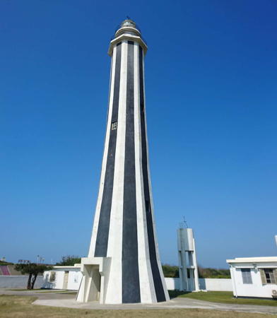

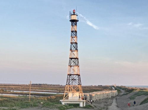
Fangyuan Light, Fangyuan, January 2020
Instagram photo by Shinyi Lin

Tainan Metropolitan City Lighthouses

Tainan is a historic port founded as a Dutch trading base in the mid 17th century. The modern city has a population of about 1.9 million. Anping is the principal harbor district of the city.

Anping District Lighthouses
* Anping South Outer Breakwater
Date unknown. Active; focal plane 24 m (79 ft); red light, 1.5 s on, 1.5 s off. 23 m (75 ft) octagonal concrete tower with gallery, painted red. Jy Tang has a photo, Tim Banan has a 2018 closeup, Trabas has Lin's photo, and Google has a satellite view. Anping is the harbor district of Tainan. In 2006-07 new breakwaters were built to extend Anping Harbor and the breakwater lighthouses were either rebuilt or relocated to the ends of the new breakwaters. Located at the end of the extended south outer breakwater of Anping. Site and tower closed. Admiralty P4629.23; NGA 13834.
* Anping North Outer Breakwater
Date unknown. Active; focal plane 24 m (79 ft); green light, 1.5 s on, 1.5 s off. 23 m (75 ft) octagonal concrete tower with gallery, painted green. Lian Weifeng has a photo, Trabas has Lin's photo, and Google has a street view and a satellite view. In 2006-07 new breakwaters were built to extend Anping Harbor and the breakwater lighthouses were either rebuilt or relocated to the ends of the new breakwaters. Located at the end of the extended south outer breakwater of Anping. Site and tower closed. Admiralty P4629.24; NGA 13829.
* Anping (Anping Chiang) (3)
1965 (station established 1891). Active; focal plane 23 m (75 ft); three white flashes every 15 s. 22 m (72 ft) square skeletal tower with lantern, gallery, and enclosed watch room. Lighthouse painted white, lantern dome black. Trabas has Lin's closeup photo, Chengnan Wu has a photo, Su I-Hua has a 2022 photo, and Google has the 2022 street view seen at right and a satellite view. The original light, a square tower, was replaced in 1909 by a round brick tower built on Anping Castle (the old Dutch Fort Zeelandia). The 1909 light appears in Huelse's postcard view. Located adjacent to a factory on the north side of Anping harbor. Site and tower closed, but the lighthouse can be seen from the street nearby. . ARLHS TAI-002; Admiralty P4628; NGA 13828.

Annan District Lighthouses
* Chengxi Incinerator
Date unknown. Active; focal plane about 30 m (98 ft); red light, pattern unknown. Approx. 30 m (98 ft) round chimney painted with gay multicolor patterns. Trabas has Felix Lin's photo and Google has a street view and a satellite view. Located on the south side of the mouth of the Zengwen River in northern Tainan. Site and tower closed. Admiralty P4629.92.

Anping Light, Tainan, July 2022
Google Maps street view

Cigu District Lighthouse
* Guosheng (Kuosheng) Kang (2)
1971 (station established 1957). Active; focal plane 34 m (112 ft); two white flashes every 15 s. 33 m (108 ft) tapered square skeletal tower with lantern and gallery, mounted on a square stone foundation. Lighthouse painted with black and white horizontal bands. A 2022 photo is available, Trabas has Lin's photo, Huang Yongyuan has a closeup street view, and Google has a street view (a portion is seen at right) and a satellite view. The original lighthouse, a 21 m (69 ft) skeletal tower, was destroyed by a typhoon in July 1970. Located on a low point of land in Cigu township about 16 km (10 mi) northwest of Tainan. Site open, tower closed. . ARLHS TAI-013; Admiralty P4630; NGA 13840.

Jiangjun District Lighthouses
* Jiangjun (Chiang-chun) South Breakwater
Date unknown. Active; focal plane about 23 m (75 ft); red light, pattern unknown. Approx. 20 m (66 ft) octagonal concrete tower. Entire lighthouse is red. No closeup photo available but Google has a satellite view and a distant street view. Located on the south breakwater of the Jiangjun Harbor in northern Tainan. Probably accessible by walking the pier. Site open, tower closed. Admiralty P4630.61.
* Jiangjun (Chiang-chun) North Breakwater
Date unknown. Active; focal plane about 23 m (75 ft); green light, pattern unknown. Approx. 20 m (66 ft) octagonal concrete tower. Entire lighthouse is green. No closeup photo available but Google has a satellite view and a distant street view. Located on the south breakwater of the Jiangjun Harbor in northern Tainan. Probably accessible by walking the pier. Site open, tower closed. Admiralty P4630.62.
 

Guosheng Light, Cigu, May 2018
Google Maps street view
 

Chiayi County Lighthouses

Budai Commercial Port Lighthouses
Budai South Breakwater
Date unknown. Active; focal plane about 20 m (66 ft); red light, pattern unknown. Approx. 16 m (52 ft) round tower. Entire lighthouse is red. Jackie Hsu has a 2021 view from the sea, Dory Hsu has a photo showing both breakwater lights, Huang Weizhen has a fuzzy street view (this light on the left) and Google has a satellite view. Budai is the terminal for fast ferries to Magong in the Penghu (Pescadores) Islands. Located on the south breakwater at the entrance to Budai Harbor. Site status unknown. Admiralty P4631.45.
Budai North Breakwater
Date unknown. Active; focal plane about 20 m (66 ft); green light, pattern unknown. Approx. 16 m (52 ft) round tower. Entire lighthouse is green. Jackie Hsu has a 2021 view from the sea, Dory Hsu has a photo showing both breakwater lights, Huang Weizhen has a fuzzy street view (this light on the right) and Google has a satellite view. Located on the north breakwater at the entrance to Budai Harbor. Site status unknown. Admiralty P4631.5.
Budai Fishing Harbor South Breakwater
Date unknown. Active; focal plane about 20 m (66 ft); green light, pattern unknown. Approx. 16 m (52 ft) round tower. Entire lighthouse is green. A closeup street view and a photo (light in the distance) are available and Google has an indistinct satellite view. Located on the north breakwater at the entrance to the fishing harbor on the north side of Budai Harbor. Site status unknown. Not listed by the Admiralty.
Budai Fishing Harbor North Breakwater
Date unknown. Active; focal plane about 20 m (66 ft); red light, pattern unknown. Approx. 16 m (52 ft) round tower. Entire lighthouse is red. IChun Chen has a 2023 photo, another photo is available and Google has an indistinct satellite view. Located on the north breakwater at the entrance to the fishing harbor on the north side of Budai Harbor. Site status unknown. Not listed by the Admiralty.

Yunlin County Lighthouses

Waisanding Lighthouses
Wenkan Tui (Wengangdui, Waisanding) (5)
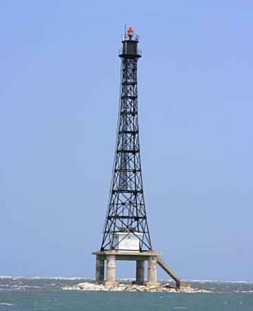
2020. Active; focal plane 58 m (190 ft); white flash every 4 s. 60 m (197 ft) square skeletal tower mounted on a square platform supported by four massive piles. Ian Chin has the April 2021 photo at right but the lighthouse is not shown in Google's satellite view. The tower is described as being painted with red and white horizontal bands but it appears all black in Chin's photo. This light station is located near the end of the Waisanding sandbar, which stretches for some 20 km (13 mi) southwest from Kouhu. It has been rebuilt or relocated at least six times, usually to accommodate changes in the sandbar or to replace towers toppled by typhoons. Located about 1.25 km (3/4 mi) southwest of the 2006 tower. Accessible only by boat. Site open, tower closed. Admiralty P4658.4; NGA 13844.
Wenkan Tui (Wengangdui, Waisanding) (4)
2006. Inactive. 38 m (125 ft) square skeletal tower topped by a square skeletal mast and mounted on a square platform supported by four massive piles. Tower painted with red and white horizontal bands. Chengnan Wu has a 2020 photo, a view from shore (this light is on the left) is available, Jock Chen has a 2021 photo, and Google has a satellite view. Lighthouse painted with red and white horizontal bands. Accessible only by boat. Site and tower closed. ARLHS TAI-054; ex-Admiralty P4658.6.
#Wenkan Tui (Wengangdui, Waisanding) (3 )
1974 (station established 1914). Apparently demolished in 2015-16. 16 m (52 ft) square skeletal tower painted black. Ian Chin has a closeup photo (incorrectly dated 2021) and an April 2015 view from shore (this light is on the right) is available but the tower is not seen in Google's satellite view. Located about 1.5 km (1 mi) north of the Waisanding lighthouse. Accessible only by boat. Site and tower closed.

2020 Wengangdui Light, Waisanding, April 2021
Google Maps photo by Ian Chin

Mailiao Lighthouses
Mailiao South Breakwater
Date unknown. Active; focal plane 24 m (79 ft); red flash every 3 s. 23 m (75 ft) octagonal concrete tower with lantern and gallery, painted red. No photo available but Google has a satellite view. Mailiao Kang is a large modern harbor enclosed by long breakwaters; it serves Taiwan's largest oil refinery. Located at the end of a short, west-pointing spur off the south breakwater. Probably accessible only by boat. Site and tower closed. ARLHS TAI-045; Admiralty P4659.415; NGA 13854.
Mailiao West Breakwater
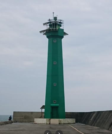
Date unknown. Active; focal plane 24 m (79 ft); white flash every 3 s. 23 m (75 ft) octagonal concrete tower with lantern and gallery, painted green. Tao Jianzhong has the photo seen at right and Google has a satellite view. Located at the end of the west (outer) breakwater. Probably accessible only by boat. Site and tower closed. Admiralty P4659.412; NGA 13855.

Changhua County Lighthouse

Fangyuan Lighthouse
**** Fangyuan (Fong Yuan)
1983. Active; focal plane 36 m (118 ft); white light, 5 s on, 5 s off. 37 m (121 ft) octagonal concrete tower with lantern and double gallery. Tower painted with black and white vertical stripes; lantern painted white with a black dome. Shinyi Lin's 2020 photo is at the top of this page, Li Ruiyuan has a 2022 photo, K.H. Yeh has a photo, Chengnan Wu has a photo, Trabas has Lin's photo, and Google has a street view and a satellite view. The lantern was transferred here from the Taichung (Cingshuei) lighthouse (see below). Located on the north side of Fangyuan. Site open, tower open daily except Mondays year round. . ARLHS TAI-007; Admiralty P4659.5; NGA 13852.

West Breakwater Light, Mailiao, May 2018
Google Maps photo by Tao Jianzhong

Taichung Metropolitan City Lighthouses

Taichung is the second largest city of Taiwan, with a population approaching 3 million, and also the second largest port.

Taichung South Harbor Lighthouses
Collier Channel South Range Front
Date unknown. Active; focal plane 38 m (125 ft); continuous green light. 28 m (92 ft) square cylindrical skeletal tower mounted atop a warehouse. The tower carries a green triangular daymark, point up. Google has a distant street view and Google has a satellite view. This range guides vessels in the southern portion of Taichung harbor. Located at the end of a quay facing the west side of the channel. Site and tower closed. Admiralty P4660.617; NGA 13921.2.
Collier Channel South Range Rear
Date unknown. Active; focal plane 72 m (236 ft); continuous green light. 68 m (223 ft) round chimney. No photo available but Google has a satellite view. Located 864 m (1/2 mi) south southwest of the front light. Site and tower closed. Admiralty P4660.618; NGA 13921.21.
Taichung West Pier Range Front
Date unknown. Active; focal plane 13 m (43 ft); continuous green light. 10 m (33 ft) square cylindrical orange skeletal tower carrying a triangular daymark. Suddhasatya Samanta has a distant view (tower to the left of the tanks) and Google has a satellite view. The range guides vessels leaving Taichung's inner harbor. Located in an liquified natural gas terminal south of the entrance to the inner harbor. Site and tower closed. Admiralty P4660.61; NGA 13921.5.
Taichung West Pier Range Rear
Date unknown. Active; focal plane 24 m (79 ft); continuous green light. 14 m (46 ft) square cylindrical orange skeletal tower carrying a triangular daymark. No photo available but Google has a satellite view. Located 116 m (380 ft) north of the front light. Site and tower closed. Admiralty P4660.611; NGA 13921.51.

Taichung Main Harbor Lighthouses
Taichung South Breakwater
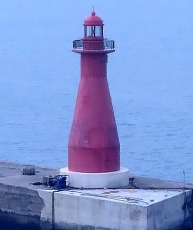
Date unknown. Active; focal plane 21 m (69 ft); red flash every 2 s. 20 m (66 ft) round concrete tower with lantern and gallery, painted red. Suddhasatya Samanta has the 2021 photo at right, Trabas has Lin's photo, Zhang Juzheng has a closeup street view and Google has a satellite view. Located at the end of the south breakwater at Taichung harbor. Probably accessible only by boat. Site and tower closed. ARLHS TAI-028; Admiralty P4660.6; NGA 13904.
 

Taichung Kang Light, Taichung, 2021
photo copyright Felix Lin; used by permission
 
Taichung Main Channel Range Front
Date unknown. Active; focal plane 45 m (147 ft); continuous light, white, red or green depending on direction. 42 m (138 ft) tapered square skeletal tower with gallery. The tower is at the left side of a photo and Google has a satellite view. This is the main harbor entrance range. Located on a main quay just inside the entrance to Taichung Kang (harbor). Site and tower closed. ARLHS TAI-049; Admiralty P4660.94; NGA 13906.
* Taichung Main Channel Range Rear
Date unknown. Active; focal plane 70 m (230 ft); continuous white light. 67 m (220 ft) tapered square skeletal tower with gallery. Trabas has Lin's photo, Google has a street view and Google has a good satellite view. Located at a major street intersection just east of the harbor facilities. Site open, tower closed. Admiralty P4660.941; NGA 13907.
* Taichung Kang
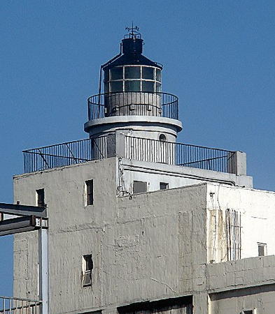
1982. Active; focal plane 62 m (202 ft); three white flashes every 30 s. 63 m (206 ft) 2-story light tower with lantern and double gallery, mounted atop a huge concrete warehouse. The building is unpainted light gray concrete. Felix Lin's photo is at right, Trabas has an older photo by Lin, Hong Min Ji has a 2017 photo, Chi Hong has a photo, and Google has a satellite view and a distant street view across the harbor. Located on the main north quay just inside the entrance to Taichung Kang (harbor). Site open, tower closed. ARLHS TAI-052; Admiralty P4660.15; NGA 13896.
Taichung North Breakwater (Taichung Harbor)
Date unknown. Active; focal plane 21 m (69 ft); white flash every 2 s. 20 m (66 ft) round concrete tower with lantern and gallery, painted green. A 2023 photo is available, Lai Shijie has a street view and Google has a satellite view. Ke Jinyuan has a photo of the lighthouse under restoration in 2010. This breakwater extends about 2.5 km (1.5 mi) into the Taiwan Strait, considerably beyond the end of the south breakwater. Located at the end of the north breakwater at Taichung harbor. Probably accessible only by boat. Site open, tower closed. ARLHS TAI-026; Admiralty P4660.4; NGA 13900.
Taichung Harbor Entry Directional (Range Front) (1 and 2)
Date unknown. Active; focal plane 11 m (36 ft) (?); continuous light, white, red or green depending on direction. The light was originally on a 16 m (52 ft) hexagonal cylindrical concrete tower; it has been moved to a square cylindrical skeletal tower, painted yellow and carrying a green triangular daymark pointed up. Jin Jiazhang has a photo, another photo is available, and Google has a satellite view. Despite its name, this is really an approach range for arriving ships rather than an entrance range. Located at an elbow of the north breakwater. Site open, tower closed. Admiralty P4660.48; NGA 13901.

Taichung Kang Light, Taichung, 2021
photo copyright Felix Lin; used by permission
Taichung Harbor Entry Range Rear
Date unknown. Active; focal plane 37 m (121 ft); continuous yellow light. 30 m (98 ft) square cylindrical skeletal tower carrying a green triangular daymark pointed down and mounted on a square platform supported by piles. Zhu Yuxian has photo and Google has a satellite view. Located north of the north breakwater, 500 m (0.3 mi) east northeast of the front light. Accessible only by boat. Site open, tower closed. Admiralty P4660.481; NGA 13901.1.

Taichung Harbor Inner Basin Lighthouses
Taichung Fishing Harbor Outer Breakwater
Date unknown. Active; focal plane 9 m (30 ft); green flash every 6 s. 7 m (23 ft) post centered on a round 1-story equipment shelter. Entire lighthouse is green. Trabas has Lin's photo and Google has a satellite view and a distant street view. Located at the entrance to the fishing harbor on the north side of Taichung's harbor. Accessible by walking the pier. Site open, tower closed. Admiralty P4660.64; NGA 13908.
Taichung Fishing Harbor West Inner Breakwater
Date unknown. Active; focal plane 8 m (26 ft); green flash every 4 s. 7 m (23 ft) post centered on a round 1-story equipment shelter. Entire lighthouse is green. Trabas has Lin's photo and Google has a street view and a satellite view. Located on a breakwater a short distance east of the Outer Breakwater Light. Accessible by walking the pier. Site open, tower closed. Admiralty P4660.66; NGA 13909.
Taichung Fishing Harbor East Inner Breakwater (2)
Date unknown. Active; focal plane 17 m (56 ft); continuous white light. Approx. 11 m (36 ft) round 2-story tower with a pagoda-style roof. Tower painted white; the roof is red. Qiu Jiarou has a 2016 photo, Trabas has Lin's photo, a 2021 photo is available, and Google has a street view and a satellite view. NGA describes an 8 m (26 ft) yellow tower. Locared on the east side of the entrance to the fishing harbor. Accessible by walking the pier. Site open, tower closed. Admiralty P4660.67; NGA 13909.5.
Taichung Harbor Craft Basin West Breakwater
Date unknown. Active; focal plane about 7 m (23 ft); green flash every 4 s. 6 m (20 ft) post centered on a round 1-story concrete equipment shelter. Entire lighthouse is green. Chi Hong has a very distant view, another distant view (light on the left) is available, and Google has a satellite view. Located on the west breakwater of an inner harbor basin of Taiching. Site status unknown. Admiralty P4660.93; NGA 13920.
Taichung Harbor Craft Basin East Breakwater
Date unknown. Active; focal plane about 7 m (23 ft); continuous red light. 6 m (20 ft) round barbell-shaped tower. Entire lighthouse is red. Chi Hong has a very distant view and Google has a satellite view. Located on the east breakwater of an inner harbor basin of Taiching. Site status unknown. Admiralty P4660.932; NGA 13920.1.
Collier Channel North (Fishing Harbor) Range Front
Date unknown. Active; focal plane 21 m (69 ft); continuous green light. 18 m (59 ft) square cylindrical tower carrying a green triangular daymark, point up. Trabas has Lin's photo and Google has a satellite view and a distant street view. This range guides vessels departing the southern harbor. The rear light is on a 28 m (92 ft) steel mast. Located at the rear of the Harbor Craft Basin. Site status unknown. Admiralty P4660.675; NGA 13921.1.
* Taichung North Jetty
Date unknown. Active; focal plane 13 m (43 ft); three white flashes every 10 s. 12 m (39 ft) round strongly tapered concrete tower attached to a square 1-story equipment shelter. Lighthouse (including the equipment shelter) painted red. Trabas has Lin's photo, a 2015 closeup is available, and Google has a satellite view.The lighthouse was formerly painted with red and white horizontal bands. Located at the end of a short pier at the south entrance to a small boat harbor north of Taichung's main harbor area. Accessible by walking the pier. Site open, tower closed. Admiralty P4660.2; NGA 13940.

Qingshui Lighthouse
**** Gaomei (Kaomei, Gau-mei)
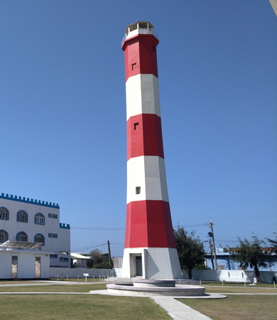
1967. Inactive since 1982 but maintained as a daybeacon. Approx. 34 m (112 ft) tapered octagonal concrete tower with gallery, painted with red and white horizontal bands. Lantern removed and transferred to the Fangyuan lighthouse (see above); it has been replaced by an observation room open to the public. Zhuo Lifen's photo is at right, WunKai Wang has a closeup and a second view, and Google has a street view and a satellite view. The red and white banded daymark is unique in Taiwan. The lighthouse was restored in 2014 and has been opened for climbing; a covered observation deck was built atop the tower in place of the lantern. Located on the coast in Qingshui (Cingshuei) township, about 4 km (2.5 mi) northeast of Taichung harbor. Site open, tower open daily except Mondays year round. . ex-Admiralty F4660.1.

Gaomei Light, Qingshui, February 2018
ex-Google Plus photo by Zhuo Lifen

Miaoli County Lighthouse

Tongxiao Lighthouse
* Tongxiao (T'ung-hsiao) South Mole
Date unknown. Active; focal plane about 10 m (33 ft); red flash every 4 s. 8 m (26 ft) round red tower mounted on a 1-story square concrete base. Trabas has Lin's photo, Rudy Chung has a street view, and Google has an indistinct satellite view. Located on the short south mole at the small Tongxiao fishing harbor. Site open, tower closed. Admiralty P4660.994.

Houlong Lighthouse
Waipu Fishing Harbor
2021. Active; focal plane about 11 m (36 ft); green light, pattern unknown. Approx. 8 m (26 ft) round concrete tower, painted in colored bands. Lightphotos.net has Lin's photo, Chen Yanru has a closeup street view, and Google has a satellite view. Located on the north mole at the small Waipu fishing harbor. Site status unknown. Admiralty P4661.05.

Hsinchu City Lighthouses

Hsinchu Fishing Harbor Lighthouses
* Hsinchu South Breakwater (1)
Date unknown. Inactive. Approx. 8 m (26 ft) post centered on a round concrete tower. The lighthouse was painted red but the paint is peeling off. Trabas has Lin's photo, Lee Hank has a 2019 photo, and Google has an indistinct satellite view. The breakwater was extended and a new post light (focal plane 14 m (46 ft); red flash every 4 s) was placed at its end. Huang Congyan has a closeup of the new light and Trabas has Lin's photo. The Admiralty continues to list the older light as active. Located on the south breakwater of Hsinchu Harbor. Site open, tower closed. Admiralty P4661.6; NGA 13949. New light: Admiralty P4661.81.
* Hsinchu North Breakwater (1)
Date unknown. Inactive. Approx. 8 m (26 ft) post centered on a round concrete tower. The lighthouse was painted white but the paint is peeling off. Trabas has Lin's photo, Lee Hank has a 2019 photo, and Google has an indistinct satellite view. The breakwater was extended and a new post light (focal plane 14 m (46 ft); red flash every 4 s) was placed at its end. Sim Chen has a closeup of the new light and Trabas has Lin's photo. The Admiralty continues to list the older light as active. Located on the north breakwater of Hsinchu Harbor. Site open, tower closed. Admiralty P4661.7; NGA 13950. New light: Admiralty P4661.8.

Information available on lost lighthouses:

Notable faux lighthouses:

Adjoining pages: North: Northern Taiwan | South: Southern Taiwan | Southwest: Penghu Islands | West: Matsu and Kinmen

Return to the Lighthouse Directory index | Ratings key

Posted September 11, 2007. Checked and revised March 13, 2024. Lighthouses: 40. Site copyright 2024 Russ Rowlett and the University of North Carolina at Chapel Hill.