Lighthouses of Eastern Taiwan

Taiwan is a large island, nearly 400 km (250 mi) long, lying about 180 km (110 mi) off the coast of China. The island was claimed by the Chinese Empire in 1683 and some of its coastal regions at least were governed by China for more than 200 years. In 1895, following the first Sino-Japanese War, China ceded control of Taiwan to Japan. Japan governed the island until the end of the Second World War in 1945. While in power the Japanese constructed several lighthouses in Taiwan that remain active today. In 1949 the collapse of Nationalist forces in mainland China led to a new governmental separation between Taiwan and the mainland, with the Nationalist government, the Republic of China (Zhōnghuá Mínguó, 中華民國), on Taiwan and the Communist government, the People's Republic of China, on the mainland. This separation continues to the present day.

For local government Taiwan is divided into 22 districts variously classified as special municipalities, cities, or counties. This page includes lighthouses of the east coast of Taiwan, including Yilan, Hualien, and Taitung Counties. The east coast of Taiwan faces the open Pacific Ocean; it is wilder and not as heavily populated as the other coasts, but it has several important harbors.

Lighthouses in Taiwan are operated by the Maritime and Port Bureau. The Bureau has adopted a program to restore and develop the light stations as tourist attractions.

There are many languages and dialects spoken in China, but Standard Chinese, often called Mandarin, is the primary language in Taiwan as it is on the mainland. The Chinese word for a lighthouse is dēngtǎ (灯塔). Jiao or chiao is a cape, dao, tao, yu, or hsu is an island, wan is a bay, and kang or gang is a harbor. Due to competing systems for transliterating Chinese into Latin characters there are always several possible spellings for the names of places in China. The Wade-Giles system was in use in Taiwan for many years, but at the beginning of 2009 the Pinyin system used on the mainland became the standard in Taiwan as well. At the present time most place names in Taiwan are still known under their Wade-Giles spellings: Keelung rather than Jilong, for example, and Kaohsiung rather that Gaoxiong.

ARLHS numbers are from the ARLHS World List of Lights. TW numbers, if known, are from the Taiwan List of Lights. Admiralty numbers are from volume P of the Admiralty List of Lights & Fog Signals. U.S. NGA List numbers are from Publication 112.

General Sources
Online List of Lights - Taiwan
Photos by various photographers posted by Alexander Trabas. The Taiwan photos are by Felix Lin.
Lighthouses in Taiwan
Photos by various photographers available from Wikimedia.
World of Lighthouses - Taiwan
Photos by various photographers available from Lightphotos.net.
Lighthouses in Taiwan
Wikipedia checklist, useful for its romanized spellings of the lighthouse names.
Leuchttürme auf Briefmarken
Postage stamp images posted by Klaus Huelse.
Leuchttürme Chinas auf historischen Postkarten
Historic postcard images of Chinese lighthouses, also posted by Klaus Huelse.
Navionics Charts
Navigational chart for eastern Taiwan.
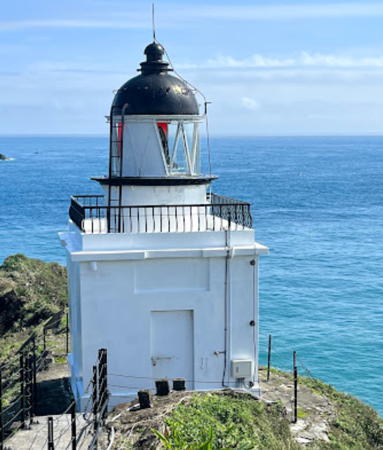

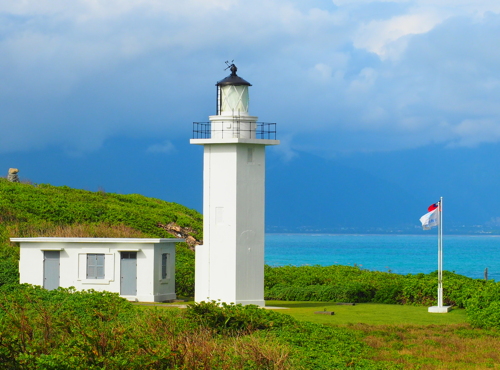
Su'ao Light, Su'ao, December 2022
Google Maps photo by Zeng Wanfu

Yilan County Lighthouses

Toucheng Township Lighthouses
Toucheng is a fishing port at the northern end of Yilan County. It has a population of about 30,000.

Toucheng Jetty Head
Date unknown. Active; focal plane about 15 m (49 ft); red light, pattern unknown. Approx. 12 m (39 ft) concrete post on a conical base. Lighthouse painted red. Trabas has Lin's photo, Pattaya Kanyati has a photo, Frank Lee has a photo, and Google has a satellite view and a very distant street view. Located at end of the north jetty at Toucheng. Site status unknown. Admiralty P4695.
Toucheng Detached Breakwater North Head
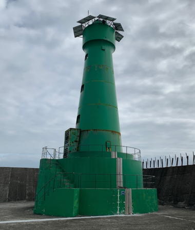
Date unknown. Active; focal plane about 15 m (49 ft); green light, pattern unknown. Approx. 12 m (39 ft) concrete post on a 1-story square concrete base. Lighthouse painted green. Hao Yuan Hung has the photo seen at right, Trabas has Lin's photo, and Google has a satellite view and a very distant street view. Located at the north end of the detached breakwater at Toucheng, opposite the Jetty Head light. Site status unknown. Admiralty P4695.1.
Toucheng Detached Breakwater South Head
Date unknown. Active; focal plane about 15 m (49 ft); yellow (?) light, pattern unknown. Approx. 12 m (39 ft) concrete post on a 1-story square concrete base. Lighthouse painted yellow. Trabas has Lin's photo and Google has a satellite view and a very distant street view. There are four similar towers between the ends of the breakwater; the Admiralty does not list them but they may be active. Located at the north end of the detached breakwater at Toucheng, opposite the Jetty Head light. Site status unknown. Admiralty P4695.8.
* Wushi Fishing Harbor North Breakwater
Date unknown. Active; focal plane about 15 m (49 ft); red light, pattern unknown. Approx. 12 m (39 ft) concrete post on a conical base. Lighthouse painted white. Trabas has Lin's photo, Johnson Chou has a street view, and Google has a satellite view. Located at the end of the north breakwater of the inner harbor at Toucheng. Accessible by walking the pier. Site open, tower closed. Admiralty P4695.4.
* Wushi Fishing Harbor South Breakwater
Date unknown. Active; focal plane about 15 m (49 ft); green light, pattern unknown. Approx. 12 m (39 ft) concrete post on a conical base. Lighthouse painted green. A view is available and Google has a street view and a satellite view. Located at the end of the south breakwater of the inner harbor at Toucheng. Accessible by walking the pier. Site status unknown. Admiralty P4695.6.

Detached Breakwater North Head Light, Toucheng, November 2018
Google Maps photo by Hao Yuan Hung
* [Guishandao (Kui-shan Tao)]
Date unknown. Active(?); focal plane 12 m (39 ft); three quick white flashes every 10 s. Approx. 10 m (33 ft) white concrete post. the light looks inactive in Sam Hsieh's 2021 photo. Google has a street view and a satellite view. Guishandao (Turtle Mountain Island), named for its reemblance from a distance, is located about 16 km (10 mi) east of Toucheng. The island is a conservation area accessible by passenger ferry. Site open, tower closed. Admiralty P4697; NGA 13682.

Su'ao Township Lighthouses
Su'ao is the principal Republic of China naval base on the east coast of Taiwan, located about 50 km (30 mi) southeast of Taipei and a similar distance north of Hualien. The city is also an important fishing port. It has a population of about 40,000.

* Su'ao (Pei Chiao, Beijiao)
1927. Active; focal plane 56 m (184 ft); flash every 7 s, white or red depending on direction. 8 m (26 ft) square cylindrical concrete tower with lantern and gallery. Lighthouse painted white; lantern dome is black. Zeng Wanfu's 2022 photo is at the top of this page, Trabas has Lin's distant view, Chen Jinlang has a 2020 photo, Wang Pinyuan has a 2016 photo, Chen Yongxu has a panoramic photo, Cinkuan Chen has a 2016 photo, there is a 2007 photo of three Su'ao lighthouses, and Google has a satellite view. The lighthouse was repaired and reactivated in 1950 after being damaged in World War II. Located at the tip of a peninsula sheltering Su'ao harbor. A long unpaved road leads to the lighthouse. Site open, tower closed. . ARLHS TAI-020; Admiralty P4700; NGA 13684.
Su'ao North Outer Breakwater
Date unknown. Active; focal plane 21 m (69 ft); two quick white flashes every 5 s. 19 m (62 ft) round concrete tower, painted white. Trabas has Lin's photo, Chien-Fu Tsai has a 2017 photo, there is a 2007 photo of both outer breakwater lighthouses, and Google has a satellite view. Located at the end of the breakwater. People fish from the pier, but it's not an easy walk to reach it. Site open, tower closed. ARLHS TAI-046; Admiralty P4700.5; NGA 13688.
Su'ao North Inner Breakwater
Date unknown. Active; focal plane 21 m (69 ft); red light, 3 s on, 2 s off. 21 m (62 ft) mast mounted on a round concrete tower, painted red. Trabas has Lin's photo and Google has a satellite view. This lighthouse is within the naval base. Located at a sharp-angled elbow of the breakwater. Site and tower closed. Admiralty P4701.15; NGA 13716.
Su'ao South Inner Breakwater
Date unknown. Active; focal plane 13 m (43 ft); green flash every 5 s. 10 m (33 ft) concrete mast rising from a 1-story concrete equipment shelter, painted green. Trabas has Lin's photo and Google has an indistinct satellite view. Located at a corner of a quay on the south side of the harbor, opposite the north inner breakwater light. Site and tower closed. Admiralty P4702.8; NGA 13700.
Nanfang Wan (Pier 13)
Date unknown. Active; focal plane 23 m (75 ft); red flash every 4 s. 23 m (75 ft) square pyramidal steel skeletal tower. Trabas has Lin's photo, Lightphotos.net has a photo, Köhler has a photo, and Google has a street view and a satellite view. Located on a commercial quay next to the approach to the Nanfang'ao Bridge. The bridge collapsed with the loss of six lives on 1 October 2019; a new bridge was completed in December 2022. Site and tower closed, but the light is easy to see from the road. TW 42200; Admiralty P4703.7; NGA 13718.
Su'ao South Outer Breakwater (2)
Date unknown. Active; focal plane about 15 m (49 ft); two quick white flashes every 5 s. Post mounted atop the round concrete base of what was originally a 19 m (62 ft) round concrete tower, painted white. A 2023 photo is at right, Trabas has Lin's photo, and Google has a satellite view. The original lighthouse was toppled by Supertyphoon Megi in September 2016; Lightphotos.net has a November 2016 photo. A dramatic photo of the original lighthouse is available, Liao Dazhao has a 2013 photo, and there is a 2007 photo of both outer breakwater lighthouses. Located at the end of the breakwater. Site and tower closed. ARLHS TAI-047; Admiralty P4700.6; NGA 13692.

South Outer Breakwater Light, Su'ao, November 2023
Google Maps photo by Keelung Port Police Corps Suao Squadron

Hualien County Lighthouses

Xiulin Township Lighthouse
Heping (Ho-p'ing Hsi) Range Front
2009. Active; focal plane 21 m (69 ft); continuous white, red or green light, depending on direction. 14 m (46 ft) round tower painted with red and white horizontal bands. The light is below right of center in Geoffrey Wu's distant view but the light is hard to find in Google's satellite view. The rear light is on a tall mast. Located in a large power plant at Heping, about 50 km (30 mi) north of Hualien. Site and tower closed. Admiralty P4704; NGA 13725.

Xincheng Township Lighthouse
* Cilaibi (Chilai Pi, Hualien) (2)
1964 (station established 1931). Active; focal plane 33 m (108 ft); white light, 3 s off, 3 s on. 13 m (43 ft) pentagonal cylindrical concrete tower with lantern and gallery. Lighthouse painted white; lantern dome is black. Three small 1-story keeper's cottages stand in a row adjacent to the lighthouse. You Qingquan's photo is at right, Trabas has Lin's closeup photo, another photo and a closer view are available, also a closeup of the lantern, Huelse has a postage stamp image, Bowei Li has a street view, Google has a street view, and Bing has a satellite view. The pentagonal cross section of this lighthouse is quite unusual. The original lighthouse, a square tower only 7.5 m (25 ft) high, was destroyed in World War II. The name of the lighthouse means Chilai Point; it preserves the original name Chilai for Hualien. Located on a headland on the north side of Hualien. Accessible by road. Site and tower closed, but the lighthouse can be viewed from nearby. . ARLHS TAI-004; TW 41140; Admiralty P4705; NGA 13728.

Hualien City Lighthouses
* Hualien (2)
1965 (station established 1910). Active; focal plane 45 m (148 ft); three green flashes every 12 s. 28 m (92 ft) tapered square skeletal tower with gallery, painted white. Vincent Chih has a 2017 closeup photo, Trabas has Lin's closeup, Sam Huang has a 2018 photo, and Google has a street view and a satellite view. The original light was on a 10 m (33 ft) post. Located on a government reservation in downtown Hualien. Site presumably open, tower closed. . ARLHS TAI-012; Admiralty P4706; NGA 13732.

Cilaibi Light, Hualien, November 2016
ex-Google Plus photo by 游清權 (You Qingquan)
Hualien Range Rear
Date unknown. Active; focal plane 24 m (79 ft); continuous red light. 21 m (69 ft) slender square steel tower, painted red and carrying a white triangular daymark. A 2016 photo is available, Trabas has Lin's closeup, and Google has a street view and a satellite view. This is a harbor entrance range. The front light is on a 12 m (39 ft) post about 600 m (3/8 mi) south southwest. Located in an industrial area at the north end of the harbor. Site and tower closed, although the light can be seen from a nearby street. Admiralty P4708.1; NGA 13740.
Hualien Range Front
Date unknown. Active; focal plane 12 m (39 ft); continuous green light. 12 m (39 ft) square pillar connected to a square 1-story equipment shelter, painted white and carrying a red triangular daymark. Trabas has Lin's photo and Google has an indistinct satellite view. Located on the west side of the fishing harbor area near the base of the east breakwater. Site status unknown. Admiralty P4708; NGA 13736.
Hualien East Breakwater
Date unknown. Active; focal plane 24 m (79 ft); red light, 2 s on, 2 s off. 23 m (75 ft) round concrete tower with lantern and gallery, painted red. A photo is at right, Tony Liu has a 2018 photo, Qiu Zhiren has another 2018 photo, Trabas has Lin's photo, and Google has a satellite view. The East Breakwater has been lengthened so that it extends parallel to the coast for about 4 km (2.5 mi), sheltering one of the largest harbors of Taiwan's east coast. Located at the end of the breakwater. Site and tower closed. . TW 41070; Admiralty P4709.1; NGA 13749.
Hualien East Breakwater Spur (South Head)
Date unknown. Active; focal plane 13 m (43 ft); red flash every 3 s. 11 m (36 ft) post rising from a round 1-story equipment shelter. Entire lighthouse is red. Trabas has Lin's closeup photo, Lin Xiongen has a 2023 photo, the light is at the lower left in Qiu Zhiren's photo, and Google has a satellite view. Located on the east side of the harbor entrance. Site and tower closed. Admiralty P4709; NGA 13748.
Hualien West Breakwater
Date unknown. Active; focal plane 18 m (56 ft); green flash every 3 s. 11 m (36 ft) post attached to a square 1-story equipment shelter. Entire lighthouse is green. Trabas has Lin's photo, Neal Doan has a 2017 photo, and Google has a satellite view. Located on the east side of the harbor entrance. Site and tower closed. Admiralty P4709.3; NGA 13750.

East Breakwater Light, Hualien, August 2023
Google Maps photo by E H

Shoufeng Township Lighthouse
* Yen-Liao (Yanliao) Fishing Harbor
Date unknown. Active; focal plane 9 m (30 ft); white light, characteristic unknown. 8 m (26 ft) tripod tower atop a 1-story equipment building. Building painted white with blue trim. Trabas has Lin's photo and Google has a street view and an indistinct satellite view. Located on the beach at the tiny Yanliao harbor, about 15 km (9 mi) south of Hualien. Site open, tower closed. Admiralty P4712.

Fengbin Township Lighthouse
Shih-ti Yü Kang (South Breakwater)
Date unknown. Active; focal plane about 13 m (43 ft); green light, pattern unknown. Approx. 12 m (39 ft) square concrete post centered on a square 1-story concrete equipment shelter. Trabas has Lin's photo and Google has an indistinct satellite view. There is an identical light tower, apparently without a light, on a spur of the breakwater, as seen in Google's street view. Located on the south breakwater at Shih-ti, a small fishing harbor in the far south of Hualien County. Site status unknown. Admiralty P4712.5.

Taitung County Lighthouses

Chenggong Township Lighthouses
* Sanshiantai (San-hsien-t'ai)
Date unknown. Active; focal plane 61 m (200 ft); white flash every 6 s. 7 m (23 ft) square concrete post with gallery, mounted on a robust octagonal concrete base. Entire lighthouse is white. Square 1-story concrete equipment shelter. Lit Han Tan has a photo, Chengnan Wu has a photo, Trabas has Lin's photo, Yapit Tseng has a street view, and Google has an indistinct satellite view. Sanshiantai is a spectacular rocky point projecting into the Pacific about 8 km (5 mi) northwest of Chenggong. Located at the tip of the promontory, accessible by a well-maintained but very steep trial. Site open, tower closed. Admiralty P4714; NGA 13752.

Lyudao Township Lighthouse
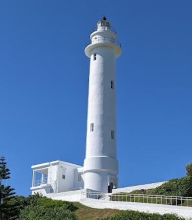
**** Lyudao (Lu Tao, Lüdao, Huo-shao Tao, Green Island) (2)
1949 (station established 1939). Active; focal plane 48 m (157 ft); two white flashes every 20 s. 30.5 m (100 ft) round concrete tower with lantern and double gallery, attached to a 1-story concrete keeper's cottage. Lighthouse painted white, lantern roof black. Xu Bochun's photo is at right, a 2008 photo, a 2011 photo, and a 2022 photo are available, Wikimedia has several photos, and Google has a street view and a satellite view. The original lighthouse was built with American contributions after the U.S. liner President Hoover ran aground on a nearby reef in December 1937; no lives were lost due to heroic rescue efforts by the islanders. Huelse has a historic photo showing the Nationalist President Chiang Kai-Shek visiting the original lighthouse before World War II. Sadly, the lighthouse was destroyed during the war. Lyudao (Lutao), or Green Island in English, is an island about 30 km (19 mi) east southeast of Taitung. The island is about 8 km (5 mi) long and 5 km (3 mi) wide. The island was the site of a political prison, now closed. It still has a prison for ordinary criminals but it is becoming popular as a beach resort and is accessible by air. The lighthouse is located at the northwestern tip of the island adjacent to the airport. In March 2013 it was announced that the light station would be opened for tours starting in September. Site open, tower open daily except Mondays year round. . ARLHS TAI-016; Admiralty P4724; NGA 13760.

Lyudao (Green Island) Light, Lyudao, July 2022
Google Maps photo by Xu Bochun

Lanyu Township Lighthouse
* Lanyu (Lan Yu, Orchid Island, Hongtouyu)
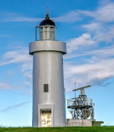
1983. Active; focal plane 216 m (709 ft); four white flashes every 24 s. 15 m (49 ft) round concrete tower with lantern and gallery. Lighthouse painted white, lantern dome black. Toshio Lee's 2022 photo is at right, Daisy Lin also has a closeup photo, Edward Mon has a photo, and Google has a street view and a satellite view. This is the highest Taiwanese lighthouse. Lanyu (Orchid Island in English) is an island about 65 km (40 mi) east of the southern tip of Taiwan, inhabited by a people related to the Batanes Islanders of the Philippines. The mountainous island is about 12 km (7.5 mi) long and 6 km (3.5 mi) wide. Prior to 1946 the island was called Hongtouyu (Red-top Island). Like Lyudao Lanyu has been opened to tourism in recent years and is accessible by air. The lighthouse is located at the northwestern tip of the island. Site open, tower closed. . ARLHS TAI-014; Admiralty P4725; NGA 13764.
* Yehyu (Yeyou, Lan Yü West Side)
Date unknown. Active; focal plane unknown; red flash every 4 s. 4 m (13 ft) round concrete tower with a domed lantern, painted white with red trim. A photo is available, Tony Wang has a 2019 photo, Wu Xiangrui has a 2022 photo, Bo Yin Lee has a street view, and Google has a distant satellite view. This little lighthouse appears to have been built by local authorities. Located on a rocky promontory at the south side of the entrance to the harbor of Yehyu, a fishing port on the west side of Lanyu. Site open, and it appears that the tower is open as well. . Admiralty P4525.55.

Information available on lost lighthouses:

Notable faux lighthouses:


Lanyu (Orchid Island) Light, July 2022
Google Maps photo by Toshio Lee

Adjoining pages: North: Northern Taiwan | East: Sakishima Islands | Southwest: Southern Taiwan

Return to the Lighthouse Directory index | Ratings key

Posted September 11, 2007. Checked and revised February 28, 2024. Lighthouses: 25. Site copyright 2024 Russ Rowlett and the University of North Carolina at Chapel Hill.