Lighthouses of Southern Taiwan

Taiwan is a large island, nearly 400 km (250 mi) long, lying about 180 km (110 mi) off the coast of China. The island was claimed by the Chinese Empire in 1683 and some of its coastal regions at least were governed by China for more than 200 years. In 1895, following the first Sino-Japanese War, China ceded control of Taiwan to Japan. Japan governed the island until the end of the Second World War in 1945. While in power the Japanese constructed several lighthouses in Taiwan that remain active today. In 1949 the collapse of Nationalist forces in mainland China led to a new governmental separation between Taiwan and the mainland, with the Nationalist government, the Republic of China (Zhōnghuá Mínguó, 中華民國), on Taiwan and the Communist government, the People's Republic of China, on the mainland. This separation continues to the present day.

For local government Taiwan is divided into 22 districts variously classified as special municipalities, cities, or counties. This page includes lighthouses of the southern coast of Taiwan in Pingtung County and Kaohsiung City.

Lighthouses in Taiwan are operated by the Maritime and Port Bureau. The Bureau has adopted a program to restore and develop the light stations as tourist attractions.

There are many languages and dialects spoken in China, but Standard Chinese, often called Mandarin, is the primary language in Taiwan as it is on the mainland. The Chinese word for a lighthouse is dēngtǎ (灯塔). Jiao or chiao is a cape, dao, tao, yu, or hsu is an island, wan is a bay, and kang or gang is a harbor. Due to competing systems for transliterating Chinese into Latin characters there are always several possible spellings for the names of places in China. The Wade-Giles system was in use in Taiwan for many years, but at the beginning of 2009 the Pinyin system used on the mainland became the standard in Taiwan as well. At the present time most place names in Taiwan are still known under their Wade-Giles spellings: Keelung rather than Jilong, for example, and Kaohsiung rather that Gaoxiong.

ARLHS numbers are from the ARLHS World List of Lights. Admiralty numbers are from volume P of the Admiralty List of Lights & Fog Signals. U.S. NGA List numbers are from Publication 112.

General Sources
Online List of Lights - Taiwan
Photos by various photographers posted by Alexander Trabas. Most of the Taiwan photos are by Felix Lin.
Lighthouses in Taiwan
Hosted by the National Kaohsiung University of Applied Science (NKUAS), this page links to individual pages on all the major lighthouses of Taiwan. Text in Chinese.
Lighthouses in Taiwan
Photos by various photographers available from Wikimedia.
World of Lighthouses - Taiwan
Photos by various photographers available from Lightphotos.net.
Lighthouses in Taiwan
Wikipedia checklist, useful for its Pinyin spellings.
Leuchttürme auf Briefmarken
Postage stamp images posted by Klaus Huelse.
Leuchttürme Chinas auf historischen Postkarten
Historic postcard images of Chinese lighthouses, also posted by Klaus Huelse.
Navionics Charts
Navigational chart for southern Taiwan.
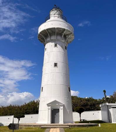

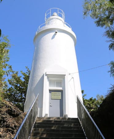
Eluanbi Light, Hengchun, October 2022
Instagram photo by apop901
Pingtung County Lighthouses

Eluanbi Peninsula Lighthouses
*** Eluanbi (Eluan Pi, O-Luan Pi)
1882 (David Marr Henderson). Active; focal plane 56 m (184 ft); white flash every 10 s. 21 m (69 ft) round cast iron tower with lantern and gallery. Lighthouse painted white, lantern dome black. 1-story keeper's house, visitor center, and other buildings. A 2022 photo is at the top of this page, Cai Chengyan has a 2021 photo, Yew Fai Chan has a fine 2007 photo, Zhang Mulin has a 2019 photo, Trabas has Lin's photo, Wikimedia has several photos, Huelse has a postage stamp image, and Google has a street view and a satellite view. This historic lighthouse predates the Japanese administration of Taiwan; it was designed by the British engineer John Ropinald and built by the Chinese Imperial government. The area was so wild at the time that the lighthouse was surrounded by defensive works and manned by soldiers. The lighthouse was repaired after being damaged by Allied air raids during World War II. A more complete restoration was carried out in 1962. Located at the southern tip of Taiwan in Hengchun, where it has been a very popular attraction in a national park since 1992. Accessible by road off national highway 28. Site open, visitor center and tower open daily except Mondays year round. Site manager: Kenting National Park. . ARLHS TAI-018; Admiralty P4602; NGA 13768.
Houbihu (Hou-Pi Hu) North Breakwater
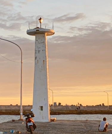
Date unknown. Active; focal plane about 7 m (23 ft); red flash every 4 s. 5 m (17 ft) post centered on a round 1-story concrete equipment shelter. Entire lighthouse is white. Trabas has Lin's photo, Shi Zhengyi has a street view of both breakwater lights, and Google has a satellite view. This is a traditional fishing harbor, but it also serves the Maanshan Nuclear Power Plant. Located on the north breakwater of Houbihu, on the west side of Nanwan (South Bay) facing the Eluanbi peninsula. Probably accessible by walking the pier. Site open, tower closed. Admiralty P4603.06; NGA 13769.5.
Houbihu (Hou-Pi Hu) South Breakwater
Date unknown. Active; focal plane about 7 m (23 ft); three green flashes every 10 s. 5 m (17 ft) post centered on a round 1-story concrete equipment shelter. Entire lighthouse is white. Trabas has Lin's photo, Shi Zhengyi has a street view of both breakwater lights, and Google has a satellite view. Located on the south breakwater of Houbihu. Probably accessible by walking the pier. Site open, tower closed. Admiralty P4603.04; NGA 13769.
#Fangliao (Fang-liao) Fishing Harbor
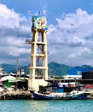
Date unknown. Removed but listed with focal plane 16 m (52 ft); continuous white light. 14 m (46 ft) square concrete skeletal tower with a round enclosure at the top. The enclosure is covered with colorful designs. A portion of Miao Hsin Sun's 2020 street view is at right, Trabas has Lin's photo and Google has a satellite view, but a 2024 street view shows only the concrete pad on which the tower stood. Fangliao is a town of about 25,000 residents on the mainland opposite Liouiou Island. NGA has the incorrect Admiralty number for this light. Located on the quay at Fangliao. Site open, tower closed. Admiralty P4606.1; NGA 13770.

Fangliao Light, Fangliao, July 2020
Google Maps street view by Miao Hsin Sun

Liouciou Island Lighthouses
* Liouciou (Liu-chu Yü, Liu-Chiu Hsu, Xiaoliuqiu, Lamay Island)
1929 (rebuilt in 1952). Active; focal plane 89 m (292 ft); white light, 2 s on, 8 s off. 11 m (36 ft) round concrete tower. Entire lighthouse is white. Andrew Huang's 2022 photo is at right, Yuren has a 2018 closeup photo, Xu Mingwei also has a 2018 closeup, Jia Chiou has a 2019 drone view, and Google has a satellite view and a street view through trees. Built by the local fisherman's association, the lighthouse was heavily damaged in World War II. Locally, the light is often called the "White Lighthouse." Liouciou (also called Lamay Island in English) is an island about 15 km (9 mi) southwest of Tungkang. Only 3 km (2 mi) long and 1.5 km (1 mi) wide, the island is a popular beach resort. The lighthouse is located on the heights above the southeastern shore of the island. Apparently accessible by hiking the service road to the lighthouse. Site open, tower closed. . ARLHS TAI-015; Admiralty P4612; NGA 13776.
* Liouciou (Liu-chu Yü, Baishawei) West Breakwater
Date unknown. Active; focal plane about 7 m (23 ft); red light, pattern unknown. 5 m (17 ft) post centered on a round 1-story concrete equipment shelter. Entire lighthouse is red. Wilson Thong has a street view of both breakwater lights and Google has a satellite view. Located on the west breakwater of Baishawei harbor, at the northeast end of the island. Accessible by walking the pier. Site open, tower closed. Admiralty P4611.2.
* Liouciou (Liu-chu Yü, Baishawei) East Breakwater
Date unknown. Active; focal plane about 7 m (23 ft); green light, pattern unknown. 5 m (17 ft) post centered on a round 1-story concrete equipment shelter. Entire lighthouse is green. Wilson Thong has a street view of both breakwater lights and Google has a satellite view. Located on the east breakwater of Baishawei harbor, at the northeast end of the island. Accessible by walking the pier. Site open, tower closed. Admiralty P4611.

Donggang Lighthouse
Donggang (Tung-kang Hsi) South Breakwater
Date unknown. Active; focal plane 11 m (36 ft); three quick red flshes every 3 s. 9 m (30 ft) concrete post with a pyramidal base. Trabas has Lin's closeup photo, an aerial view is available, and Google has a street view from shore and a satellite view. This light and the next one are only a few meters apart. Donggang is an important fishing port with a population of about 50,000.
Located on the main breakwater at Donggang. Site status unknown. Admiralty P4607.1.
Donggang (Tung-kang Hsi) South Breakwater Head
Date unknown. Active; focal plane 11 m (36 ft); three white flshes every 10 s. 9 m (30 ft) concrete post with a broad base. Entire lighthouse is red. Trabas has Lin's closeup photo, an aerial view is available, and Google has a street view from shore and a satellite view. Located on the main breakwater at Donggang. Site status unknown. Admiralty P4608.

Liouciou Light, September 2022
Google Maps photo by Andrew Huang

Kaohsiung City Lighthouses

Kaohsiung is the metropolis of southern Taiwan with a population of about 2.75 million. It has the nation's largest port and is the headquarters of the Republic of China Navy.

Southern Harbor Lighthouses
Kaohsiung West Breakwater
2018. Active; focal plane 27 m (89 ft); red light, 1.5 s on, 4.5 s off. 20 m (66 ft) round concrete tower. Entire lighthouse is red. Nekoya Hu has a 2022 closeup photo, Trabas has a fuzzy photo by Darlene Chisholm and Google has a satellite view. The Admiralty calls this the South Breakwater Light. The South Entrance leads to a new containership harbor about 8 km (5 mi) southeast of the traditional harbor of Kaohsiung. Located at the end of a new breakwater extending beyond the end of the original south breakwater. Site open only to rod fishing, tower closed. Admiralty P4624.42; NGA 13792.
#Kaohsiung Second (South) Entrance South Breakwater (1)
Date unknown. Replaced in 2018 by a much smaller light after the breakwater was shortened. This was a 13 m (43 ft) 2-stage square cylindical concrete tower, painted red. Tomas Juricek has a distant 2015 street view of both breakwater lights and Google has a satellite view of the former location. Formerly located at the end of the south breakwater. ARLHS TAI-044. Current light: Admiralty P4624.415.
Kaohsiung Second (South) Entrance North Breakwater
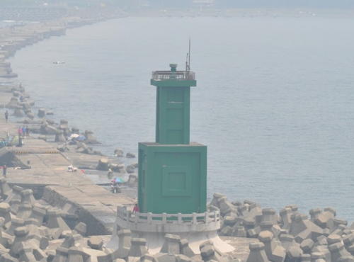
Date unknown. Active; focal plane 18 m (59 ft); one long and two short white flashes every 10 s. 13 m (43 ft) 2-stage square cylindical concrete tower, painted green. David Bowley's photo is at right, Tomas Juricek has a distant street view of both breakwater lights and Google has a satellite view. The South Entrance leads to a new industrial harbor about 8 km (5 mi) southeast of the traditional harbor of Kaohsiung. Located at the end of the north breakwater. ASite and tower closed. ARLHS TAI-043; Admiralty P4624.4; NGA 13788.
Kaohsiung Second Entrance Range Front
Date unknown. Active; focal plane 38 m (125 ft); two continuous lights, red above green. 37 m (121 ft) round steel tower carrying a triangular daymark. No photo available but Google has a satellite view. These range lights are among the tallest mast-style lights in the world. Located in the midst of the container terminal. Site and tower closed. Admiralty P4624.5; NGA 13793.

Second Entrance North Breakwater Light, Kaohsiung, April 2015
Google Maps photo by David Bowley
Kaohsiung Second Entrance Range Rear
Date unknown. Active; focal plane 48 m (157 ft); two continuous lights, red above green. 37 m (121 ft) round steel tower carrying a triangular daymark. Google has a street view and a satellite view. Located beside the main entrance of the container terminal 490 m (0.3 mi) east of the front light. Site and tower closed. Admiralty P4624.51; NGA 13793.1.

Main Harbor Lighthouses
**** Kaohsiung (Cihou, Chihou, Qihou, Cijin)
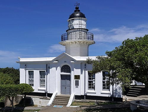
1883 (extensively altered in 1918). Active; focal plane 58 m (190 ft); four white flashes every 30 s. 15 m (49 ft) octagonal cylindrical brick tower with lantern and gallery, rising from a 1-story brick keeper's house. Lighthouse painted white, lantern dome black. A 2021 photo is at right, James Lin has a good photo, Trabas has Darlene Chisholm's closeup photo, Chen Kaiyu has a 2020 photo, Wikimedia has many photos, Huelse has a historic postcard view, and Google has a street view and a satellite view. This historic lighthouse, one of the best known and most visited of all Taiwanese lighthouses, is built on a great rock commanding the entrance to the harbor of Kaohsiung. It was designed by the British engineer John Reginald Harding for the Imperial government. It was rebuilt and upgraded by the Japanese in 1918 and was one of the few major Taiwanese lighthouses to escape World War II undamaged. The keeper's house is now a museum. The lighthouse reopened in July 2020 following an extensive restoration. Located atop Qihou Hill at the north end of Cijin (Qijin) Island in Kaohsiung. Site open, museum and tower open daily except Mondays year round. . ARLHS TAI-001; Admiralty P4618; NGA 13796.

Kaohsiung Light, Kaohsiung, May 2021
Wikimedia Creative Commons photo by Deepblue5042
* Kaohsiung South Breakwater
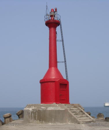
Date unknown. Active; focal plane 15 m (49 ft); red flash every 3 s. 14 m (46 ft) post centered on a round 1-story equipment shelter. Entire lighthouse painted red. A photo is at right, Wai On Li has a 2020 photo, Trabas has Darlene Chisholm's photo, Chun-Yen Steven Huang has a photo and Bing has a satellite view. Located at the end of the south breakwater, which begins below the historic lighthouse. Accessible by walking the pier. Site open, tower closed. Admiralty P4621; NGA 13804.
Kaohsiung Container Terminal No. 1
Date unknown. Active; focal plane 27 m (89 ft); quick-flashing red light. 25 m (82 ft) round steel tower with gallery. No photo available but Google has a satellite view. Located on a quay in the main harbor of Kaohsiung. Site and tower closed. Admiralty P4621.52; NGA 13794.
* Kaohsiung North Breakwater
Date unknown. Active; focal plane 15 m (49 ft); white light, 2 s on, 2 s off. 14 m (46 ft) post centered on a round 1-story equipment shelter. Entire lighthouse painted green. Trabas has Tom Chisholm's photo, Brad Huang has a 2017 street view, Chun-Yen Steven Huang has a photo and Bing has a satellite view. The lighthouse was formerly painted white; it was repainted green in 2008. Located at the end of the north breakwater. Accessible by walking the pier. Site open, tower closed. Admiralty P4620; NGA 13800.

Zuoying Naval Harbor Lighthouses
Zuoying (Tsoying) Naval Base South Breakwater
Date unknown. Active; focal plane 19 m (62 ft); red flash every 6 s. Approx. 17 m (56 ft) tower mounted on a pyramidal concrete base. Lighthouse painted red. No photo available but Google has a satellite view. Located at the end of the south breakwater at the Zhouying Naval Base on the north side of Kaohsiung. Site and tower closed. Admiralty P4625.2; NGA 13812.
Zuoying (Tsoying) Naval Base South Inner Breakwater
Date unknown. Active; focal plane 14 m (46 ft); red flash every 5 s. Approx. 11 m (36 ft) post rising from a round 1-story equipment shelter. Lighthouse painted red. No photo available but Google has a distant satellite view. Located at the end of the original south breakwater at the Zhouying Naval Base. Site and tower closed. Admiralty P4625.4; NGA 13816.
Zuoying (Tsoying) Naval Base (North Breakwater)
Date unknown. Active; focal plane 19 m (62 ft); white flash every 6 s. Approx. 17 m (56 ft) tower mounted on a pyramidal concrete base. Lighthouse painted white. No photo available but Google has a satellite view. Located at the end of the north breakwater at the Zhouying Naval Base. Site and tower closed. Admiralty P4625; NGA 13808.

Kaohsiung South Breakwater Light, Kaohsiung, May 2008
ex-Panoramio Creative Commons photo by Taiwan泰

Kezilao (Ho-Tzu-Liao) Fishing Harbor Lighthouse
* Kezilao Entrance
Date unknown. Inactive (a streetlight is atop the tower). Approx. 13 m (43 ft) square white concrete tower. Chen Huihua has a 2020 street view (also seen at right), Tung Lung Lin has a photo, and Google has a satellite view. The light has been replaced by post lights on the outer breakwaters of the harbor. This harbor serves a large fish market. Located on a pier in the center of the Kezilao harbor, about 3 km (1.8 mi) north of the Zuoying entrance. Accessible by walking the pier. Site open, tower closed.

Yong'an LNG Harbor Lighthouses
Yong'an Main Breakwater Inner
Date unknown. Inactive. Approx. 20 m (66 ft) round strongly conical white concrete tower. Li Wenming has a view showing all three breakwater lights and Google has a satellite view. Located at the original end of the main (south) breakwater at the Yong'an commercial harbor on the north side of Kaohsiung, about 13 km (8 mi) north of the Naval Base. Site and tower closed. ex-Admiralty P4626.41.
Yong'an Main Breakwater Outer
Date unknown. Active; focal plane 28 m (92 ft); red flash every 4 s. 21 m (69 ft) octagonal concrete tower. Lighthouse painted red. Trabas has Lin's photo, Li Wenming has a view showing all three breakwater lights, and Google has a satellite view. Located at the end of the extended main (south) breakwater of the Yong'an commercial harbor, about 300 m (0.2 mi) north of the older lighthouse. Site and tower closed. Admiralty P4626.4; NGA 13825.1.
Yong'an ("Tug Berth")
Date unknown. Active; focal plane 23 m (75 ft); white flash every 5 s. 20 m (66 ft) round white concrete tower. The light is visible near the right edge of Su Rongchi's distant view of the harbor and Google has a satellite view. Tugboats are seen in the harbor in Rongchi's photo. Located near the base of the south breakwater at the Yong'an harbor. Site and tower closed. Admiralty P4626.3; NGA 13825.
Yong'an North Breakwater
Date unknown. Active; focal plane 27 m (89 ft); green flash every 4 s. 21 m (69 ft) octagonal concrete tower. Lighthouse painted green. Trabas has Lin's photo, Li Wenming has a view showing all three breakwater lights, and Google has a satellite view. Located at the end of the north breakwater at the Yong'an commercial harbor. Site and tower closed. Admiralty P4626.43; NGA 13825.12.

Kezilao Entrance Light, Kaohsiung, July 2020
Google Maps street view by Chen Huihua

Xing Da Fishing Harbor Lighthouses
Xing Da (Hsing-ta) South Breakwater
Date unknown. Active; focal plane about 14 m (46 ft); red flash every 5 s. Approx. 11 m (36 ft) post centered on a round 1-story white concrete equipment shelter. Trabas has Lin's photo, Akihito Hsueh has a 2021 photo, and Google has a street view and a satellite view. Xing Da is a fishing harbor that also serves a power plant. Located on the south breakwater at Xing Da on the north side of Kaohsiung. Site status unknown. Admiralty P4627.4.
Xing Da (Hsing-ta) North Breakwater
Date unknown. Active; focal plane about 14 m (46 ft); green flash every 4 s. Approx. 11 m (36 ft) post centered on a round 1-story green concrete equipment shelter. Akihito Hsueh has a 2021 photo and Google has a distant street view and a satellite view. Located on the north breakwater at Xing Da on the north side of Kaohsiung. Site status unknown. Admiralty P4627.45.

Information available on lost lighthouses:

Notable faux lighthouses:

Adjoining pages: North: Western Taiwan | East: Eastern Taiwan | South: Northern Philippines | West: Penghu Islands

Return to the Lighthouse Directory index | Ratings key

Posted September 11, 2007. Checked and revised March 6, 2024. Lighthouses: 28. Site copyright 2024 Russ Rowlett and the University of North Carolina at Chapel Hill.