Lighthouses of Russia: Vyborg Area

Russia (Россия, Rossiya in Russian) is by far the world's largest country, spanning a little over 150° in longitude. It is organized as the Russian Federation (Rossiyskaya Federatsiya) with members known as federal subjects (sub'yekty federatsii). Russia is primarily a continental nation but it has important coastlines on the Baltic, Black, and Caspian Seas and very long coastlines on the Arctic Ocean and North Pacific Oceans. To guard these coasts it operates hundreds of lighthouses, many of them historic.

The Gulf of Finland, the eastern arm of the Baltic Sea, extends about 425 km (265 mi) to end at St. Petersburg, Russia's traditional western outlet to the sea. For most of its length the Gulf is 60-120 km (38-75 mi) wide. The eastern quarter of the Gulf's length is surrounded by Russian territory and the western 3/4 separates Finland on the north from Estonia on the south. This page includes lighthouses of the Vyborgsky District on the north side of the Gulf. The district is part of Leningrad Oblast (province), one of the members of the Russian Federation.

After being captured by Russia from Sweden in the Eighteenth Century, this area was part of the Grand Duchy of Finland within the Russian Empire. In 1917 Finland declared its independence from Russia, placing this area in Finland. Vyborg, known then as Viipuri, was the second largest city of Finland until World War II. During that war Soviet troops occupied the area and under the Paris Peace Treaty of 1947 it remained under Soviet, and now Russian, control.

The Russian word for a lighthouse is mayak (маяк); ostrov is an island, rif is a reef, mys is a cape, bukhta is a bay, zaliv is a larger bay or gulf, proliv is a strait, reka is a river, and gavan' is a harbor.

Curly braces {} are used to enclose former Finnish names of the lighthouses, where known.

Russian lighthouses are owned by the Russian Navy and maintained by the Office of Navigation and Oceanography (Управление навигации и океанографии).

ARLHS numbers are from the ARLHS World List of Lights. Russian light list (RU) numbers are from Russian Navy Publication 2201, as reported by the Admiralty. Admiralty numbers are from volume C of the Admiralty List of Lights & Fog Signals. U.S. NGA List numbers are from Publication 116.

General Sources
Online List of Lights - Baltic Russia
Photos by various photographers posted by Alexander Trabas.
Lightphotos.net - Russia - Baltic Sea and Gulf of Finland
Photos by various photographers available from Lightphotos.net.
Lighthouses in Leningrad Oblast
Photos by various photographers available from Wikimedia.
Russische Leuchttürme auf historischen Postkarten
Postcard views of historic Russian lighthouses posted by Klaus Huelse.
Navionics Charts
Navigational chart for the Gulf.


Stirsudden Light, Mys Seyveste, July 2021
Instagram photo by Katerina Ivanina

Mys Stirsudden Area Lighthouses
Mys Pesochnyy
Date unknown. Inactive but still listed with focal plane 36 m (118 ft); white flash every 4 s. 21 m (69 ft) square cylindrical skeletal tower, painted red. A white slatted daymark with a black vertical stripe is also listed. However, Mikhail Nechayev has a 2018 photo showing the daymark in tatters and no sign of an active light. Mikhail Miroshnichenko has a winter distant view, Artyom Usachev has a street view from atop the tower, and Google has a satellite view. The Admiralty listed the light as "temporarily extinguished" in 2013. Located on a cape near Pesochnoye, about 23 km (14 mi) east of the Stirsudden lighthouse. Site open, tower unguarded but dangerous. Admiralty C5588.
Mys Flotskiy
Date unknown. Active; focal plane 24 m (79 ft); white flash every 3 s. 20 m (66 ft) square cylindrical skeletal tower, painted red. A white daymark is listed, but the 2011 photo at right shows none. Lyudmila Vasilyeva has a distant view and Bing has a satellite view. Located on Mys Flotskiy, a sandy headland about 7 km (4 mi) east of the Stirsudden lighthouse. Site open, tower closed. Admiralty C5586; NGA 13081.
Stirsudden (Mys Seyveste) {Seivästö} (3)
1955 (station established 1873). Active; focal plane 47 m (154 ft); two white flashes every 15 s. 28 m (92 ft) round cylindrical concrete tower with lantern and gallery, rising from a 1-story cement block base. Lighthouse painted with red and white horizontal bands; lantern is red. 1-story brick keeper's house and other light station buildings. Katerina Ivanina's photo is at the top of this page, Geocaching.su has a page with a photo and the history of the station (in Russian), Trabas has Klaus Kern's photo, Wikimedia has Vitold Muratov's photo, a Soviet postage stamp featured the lighthouse, the tower is seen through the forest in Google's street view, and Bing has a satellite view. Huelse has a historic postcard view of the original lighthouse, a handsome octagonal tower built with Estonian bricks. The historic lighthouse was destroyed during World War II and replaced by a temporary tower. This light station guards the north side of the entrance to the narrow extension of the Gulf of Finland leading to St. Petersburg, just as the Mys Shepelevski Light (see the Ingria page) guards the southern entrance. It is also a leading light for vessels beginning the eastern approach to Vyborg. Located atop a cliff on the cape Mys Seyveste, southeast of Ozerki and about 40 km (25 mi) southeast of Vyborg. The station is just off the main A123 highway between Vyborg and St. Petersburg. Site and tower closed but many visitors have taken photos from nearby. . ARLHS ERU-008; Admiralty C5584; NGA 13080.
Kyurënniemi (Kyurenniyemi) {Kyrönniemi}
Date unknown. Active; focal plane 25 m (82 ft); white flash every 3 s. 21 m (69 ft) square cylindrical skeletal tower, painted red. The upper portion of the tower carries a daymark painted white with a black vertical stripe. A closeup 2018 photo is available, Pavel Zakharov also has a photo, and Google has an indistinct satellite view. In the Soviet era this was one of the lighthouses powered by a radioisotope thermoelectric generator (RTG). Soviet-era RTG's were powered by highly radioactive strontium 90, and the presence of these increasingly dilapidated and dangerous power units in unattended lighthouses was and is a matter of grave international concern. Several sources mention radiation dangers at this lighthouse, so extreme caution is needed. Located on a sharp cape about 11 km (7 mi) northwest of the Stirsudden lighthouse (next entry). Site open, tower closed. Admiralty C5582; NGA 13084.
Mys Flotskiy Light
Mys Flotskiy Light, Zelenaya Roshcha, February 2011
ex-Panoramio Creative Commons photo by GES-RU

Primorsk and Berezovyy Islands Area Lighthouses
There are several possible approaches to Vyborg through the shallow and island-strewn Vyborg Bay. For larger vessels the best approach is along the eastern shore of the bay in the B'yorkozund Strait, between the mainland and a series of large islands.

Yermilovskiy (Mys Okhrity) Range Front
Date unknown. Active; focal plane 29 m (95 ft); white light occulting once every 3 s. 25 m (82 ft) round post with gallery; the tower also carries a large vertically slatted rectangular daymark. Lighthouse painted white, daymark panels red. No photo available but Google has a satellite view. This range guides vessels eastbound in the Gulf of Finland on a northeast reach to begin the approach to Vyborg. Located on a mainland promontory about 3 km (1.8 mi) southeast of Ostrov Syarkkyaluoto. Site status unknown. Admiralty C5569; NGA 13085.
* Yermilovskiy (Mys Okhrity Range Rear)
Date unknown. Active; focal plane 63 m (207 ft); white light occulting once every 3 s. 25 m (82 ft) round post with gallery; the tower also carries a large vertically slatted rectangular daymark. Lighthouse painted white, daymark panels red. Trabas has Klaus Kern's photo, a 2016 photo is available, and Google has a street view and a satellite view. Located beside the A123 highway (linking Vyborg to St. Petersburg) about 930 m (0.58 mi) northeast of the front light. Site fenced but there is a good view from the highway. Admiralty C5569.1; NGA 13086.
Ostrov Syarkkyaluoto
Date unknown. Active; focal plane 15 m (49 ft); red flash every 5 s. 12 m (39 ft) square cylindrical tower with lantern, painted white with narrow black horizontal bands. Diko Pofig has a winter 2014 photo and Google has a satellite view. Located on a gravel bar off the entrance to the bay of Baltiskoye, about 5 km (3 mi) east of the Mys Pervyy Zubets light (next entry). Accessible only by boat. Site open, tower closed. Admiralty C5568; NGA 13088.
Mys Dlinnyy
Date unknown. Active; focal plane 20 m (66 ft); one long white flash every 6 s. 17 m (56 ft) concrete post carrying a large funnel-shaped structure as a daymark. Lighthouse painted white. Google has an indistinct satellite view. Located on the southeastern tip of Bolshoy Berezovyy island. Site status unknown. Admiralty C5570.
Mys Pervyy Zubets (Ostrov Dlinnobereznyi) {Verkkoluoto}
Date unknown. Active; focal plane 6 m (20 ft); flash every 2 s, white, red or green depending on direction. 6 m (20 ft) square red brick tower with lantern and gallery; lantern painted white. Tatiana Bashinskaya's photo is at right, Nikita Novozhilov has a view from the sea, and Google has a satellite view. Located on a gravel bar off Mys Pervyy Zubets, the cape at the eastern end of Bolshoy Berezovyy island, about 16 km (10 mi) southeast of Primorsk. Accessible only by boat. Site open, tower closed. Admiralty C5567; NGA 13092.
Mys Pochyotnyy Range Front
Date unknown. Active; focal plane at least 20 m (66 ft); white light, pattern unknown. Approx. 20 m (66 ft) square skeletal tower. no photo available but Bing has a satellite view. This range guides ships on a southeast reach approaching Primorsk from Vyborg. Located west of Mys Pochyotnyy on Bolshoy Berezovyy island. Site status unknown. Admiralty C5563.
Mys Pochyotnyy Range Rear
Date unknown. Active; focal plane at least 30 m (98 ft); white light, pattern unknown. Approx. 30 m (98 ft) square skeletal tower. no photo available but Bing has a satellite view. Located south of Mys Pochyotnyy on Bolshoy Berezovyy island, about 800 m (1/2 mi) southeast of the front light. Site status unknown. Admiralty C5563.1.
Pervyy Zubets Light
Mys Pervyy Zubets Light, July 2010
Wikimedia Creative Commons photo by Tatiana Bashinskaya
Primorsk (Mys Lotsmanskiy)
Date unknown. Active; focal plane 27 m (89 ft); two flashes every 6 s, white, red or green depending on direction. 20 m (66 ft) square cylindrical skeletal tower. No photo available but Bing has an indistinct satellite view. This is a leading light for vessels bound both directions in the B'yorkozund Strait. Located on a promontory at Primorsk, a historic town now the site of a large oil export terminal. Site and tower probably closed. Admiralty C5562; NGA 13100.
Vyborgskiy Zaliv (Range Rear) (Severnyy Berezovyy) {Alvatiniemi} (2)
Date unknown (station established 1903). Active; focal plane 39 m (128 ft); one long flash every 6 s, white, red or green depending on direction. 35 m (115 ft) square skeletal tower; the upper portion of the tower is surrounded by a cylindrical daymark, painted white. Google has a satellite view. This range guides vessels crossing Vyborg Bay in the central approach; it is also a leading light guiding vessels southbound in the eastern approach. Located at the northern tip of the island of Severnyy (North) Berezovyy, about 12 km (7.5 mi) northwest of Primorsk. Site status unknown. Admiralty C5500.1; NGA 13108.
Vyborgskiy Zaliv (Range Front) (Ostrov Rondo)
Date unknown (station established 1903). Active; focal plane 14 m (46 ft); flash every 1.5 s, white, red or green depending on direction. 10 m (33 ft) square skeletal tower, painted red, carrying a daymark painted white with a black vertical stripe. No photo available, but Google has a satellite view. This is a leading light guiding vessels in both directions in the central approach to Vyborg. Located at the north end of Ostrov Rondo, about 6 km (3.5 mi) west southwest of the rear light. Accessible only by boat. Site status unknown. Admiralty C5500; NGA 13104.

Vysotsk Area Lighthouses

The large island of Vysotskiy lies across the middle of Vyborg Bay. Vessels bound to and from Vyborg use a narrow passage around the north end of the island at the town of Vysotsk (Vysock).
Mys Povorotnyy (Ostrov Mayachnyy)
1924. Active; focal plane 18 m (60 ft); flash every 1.5 s, white, red, or green depending on direction. 10 m (33 ft) octagonal tower with lantern and gallery. Tower painted white with a red horizontal band at the base; lantern painted red. Ale Davydova's photo is at right, Vladislav Bogomolov has a 2017 photo, Timofey Fedorov has a nice view from the sea, and Google has a satellite view. This light has two narrow white sectors defining a sharp turn in the approach to Vyborg. The lighthouse was built under Finnish rule and has a typically Finnish design. Note: Russia has another Mys Povorotnyy Light near Nakhodka on its Sea of Japan coastline, many thousands of miles to the east. Located on a small island off Mys (Cape) Povorotnyy, about 3 km (2 mi) southeast of Vilaniyemi and about 30 km (19 mi) southwest of Vyborg. Accessible only by boat. Site open, tower closed. . ARLHS ERU-057; Admiralty C5506; NGA 13112.
Banka Khalliviki (Mys Ostryy Range Front)
Date unknown. Active; focal plane 8 m (26 ft); yellow flash every 1.5 s. 4.5 m (15 ft) round concrete tower mounted on a square pyramidal concrete platform. Lighthouse painted white with a black vertical stripe. Wikimedia has Vladimir Maximov's photo and Google has a satellite view. This range that guides ships northward toward Vysotsk. Located on a shoal 926 m (0.58 mi) southwest of the rear light. Accessible only by boat. Site open, tower closed. Admiralty C5514; NGA 13120.
Ostrov Krepysh (Mys Ostryy Range Rear)
Date unknown. Active; focal plane 20 m (66 ft); yellow light, 2 s on, 1 s off. 16 m (52 ft) concrete tower, painted white with a black vertical stripe on the range line. No photo available but Google has a satellite view. Located at the tip of a densely forested peninsula about 2 km (1.2 mi) southwest of Vysotsk. Site status unknown. ARLHS ERU-316; Admiralty C5514.1; NGA 13124.
[Vysotskiy Severnyy (Vysotsk North)]
Date unknown. Active; focal plane 9 m (30 ft); two red flashes every 5 s. 5 m (17 ft) post, painted red with a white horizontal band. Aleksandr Martyanov has a photo of the two Vysotsk lights and Google has a satellite view. All ships sailing to or from Vyborg must pass between this light and the next one. Located at the end of the south breakwater of the Vysotskiy strait. Accessible only by boat. Site status unknown. Admiralty C5515.5.
[Vysotskiy Yuzhnyy (Vysotsk South)]
Date unknown. Active; focal plane 9 m (30 ft); flash every 1.5 s, white, red or green depending on direction. 5 m (17 ft) post, painted green with a white horizontal band. Aleksandr Martyanov has a photo of the two Vysotsk lights and Google has a satellite view. This directional light guides vessels in the dredged channel approaching Vysotsk. Located at the end of the south breakwater of the Vysotskiy strait. Accessible only by boat. Site status unknown. Admiralty C5516.5 (ex-C5518); ex-NGA 13132.

Mys Povorotnyy Light, Vyborg Bay, July 2020
Instagram photo by ale_davydova
* Pikhtovyy (Vysotskiy-Yuzhnyy Range Rear)
Date unknown. Inactive since 2012. 16 m (52 ft) round cylindrical concrete tower, painted white with a black vertical stripe on the range line. Google has a street view and an indistinct satellite view. This light was formerly the rear light of a range having the Vysotskiy Yuzhnyy light as the front light. Located between a road and a rail line about 2 km (1.2 mi) south of Vysotsk. Site probably open, tower closed. ARLHS ERU-320; ex-Admiralty C5518.1; ex-NGA 13136.
Vysotskiy-Vkhodnoy Range Front
Date unknown. Active; focal plane 15 m (49 ft); yellow light occulting once every 3 s. 20 m (66 ft) skeletal tower. Approx. 11 m (36 ft) square concrete (?) tower. No photo available but Google has a satellite view. These range lights guide vessels through the narrow Vysotskiy gateway. Located in an industrial zone on the south side of Vysotsk. Site and tower closed. Admiralty C5517.
Vysotskiy-Vkhodnoy Range Rear
Date unknown. Active; focal plane 17 m (56 ft); yellow light occulting once every 3 s. 16 m (52 ft) square cylindrical skeletal tower. Google has a street view and Bing has an indistinct satellite view. Located 370 m (400 yd) east of the front light. Site and tower closed. Admiralty C5517.1.
* Ostrov Patteri Range Rear
Date unknown. Active; focal plane 22 m (72 ft); white light, 2 s on, 2 s off. 16 m (52 ft) concrete tower, painted white with a red vertical stripe on the range line; the tower also carries a white funnel-shaped structure as a daymark. No lantern. Dennis Eremin has posted a photo and Google has a street view and an indistinct satellite view. This is the rear light of a southbound range for vessels approaching Vysotsk from Vyborg. Located about 2 km south of Vysotsk. Site open, tower closed. ARLHS ERU-222; Admiralty C5530.1; NGA 13164.
* Ostrov Patteri Range Front
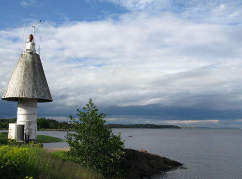
Date unknown. Active; focal plane 13 m (43 ft); quick-flashing white light. 11 m (36 ft) concrete tower, painted white with a red vertical stripe on the range line; the tower also carries a white funnel-shaped structure as a daymark. Dimitriy Rusanov's photo is at right, a closeup is available, and Google has a street view and an indistinct satellite view. Located on the beach near the northern tip of Ostov Vysotskiy. Site open, tower closed. Admiralty C5530; NGA 13160.
Ostrov Patteri Range Rear Light
Ostrov Patteri Range Front Light, Vyborg Bay, June 2010
ex-Panoramio Creative Commons photo by Dimitriy Rusanov

Vyborg Area Lighthouses
Vyborg, called Viipuri in Finnish and Viborg in Swedish, is a city of about 80,000 people located at the north end of Vyborg Bay. Founded by Sweden around 1300, the city was captured for Russia by Peter the Great in 1710. Between World Wars I and II Viipuri was the second-largest city of Finland. It is the administrative center for Vyborgsky District.

Sokolinskiy (Range Rear)
Date unknown. Active; focal plane 19 m (62 ft); yellow light, 1 s on, 1 s off. 17 m (56 ft) round tower, probably with lantern and gallery, painted white. No photo available but Google has a satellite view. This is a southbound range for vessels passing Vyborg from farther north in Vyborg Bay. Located on the east shore of Vyborg Bay about 3 km (2 mi) south of the city. Site status unknown. Admiralty C5543.9; NGA 13222.
Zashchitnyy
Date unknown. Active; focal plane 11 m (36 ft); red light occulting once every 3 s. 6 m (20 ft) post surrounded by a round cylindrical daymark painted white with a red vertical stripe. No photo available but Google has a satellite view. This is the rear light of a southbound range guiding vessels away from Vyborg. The front light is also the front light for the Mariankivi range (see below). Located on the south point of an island about 4 km (2.5 mi) southwest of the city's waterfront. Accessible only by boat. Site open, tower closed. Admiralty C5542.1; NGA 13216.
Kuposenkivi (Range Front)
Date unknown. Active; focal plane 12 m (39 ft); flash every 1.5 s, white or red depending on direction. 8 m (26 ft) round cylindrical white concrete tower mounted on a concrete base. No photo available but Google has a satellite view. Located about 500 m (0.4 mi) south of the Mariankivi light (next entry). Accessible only by boat. Site open, tower closed. Admiralty C5546; NGA 13228.
Mariankivi (Range Rear)
Date unknown. Active; focal plane 14 m (46 ft); white or red light, depending on direction, occulting once every 3 s. 11 m (36 ft) square skeletal tower, painted black. 3/4 of the tower is surrounded by a round daymark painted red with a white vertical stripe on the range line. Trabas has Werner Seiler's photo and Google has a satellite view. This is a northbound range guiding vessels on the approach to Vyborg. Located in Vyborg Bay about 2 km (1.25 mi) southeast of the city's waterfront. Accessible only by boat. Site open, tower closed. Admiralty C5541.9; NGA 13212.
* Vyborg Yuzhnyy (South Vyborg) (Range Rear)
Date unknown. Active; focal plane 31 m (102 ft); quick-flashing red light. Light mounted atop an 18 m (59 ft) grain elevator. Google has a street view and a satellite view. This is a northbound range guiding vessels on the approach to Vyborg. The front light is the Kuposenkivi light (see above). Located on the south side of downtown Vyborg. Site open, tower closed. Admiralty C5546.1; NGA 13232.
* Vyborg Severnyy (North Vyborg) (Range Rear)
Date unknown. Active; focal plane 23 m (75 ft); red light, 2 s on, 1 s off. 9 m (30 ft) concrete post carrying a large funnel-shaped structure as a daymark. Lighthouse painted white with a red vertical stripe on the range line. Trabas has Klaus Kern's photo, Wikimapia has photos, Andrei Panis'ko has a good photo, Slava Svetlov has a 2021 closeup, and Google has a street view and a satellite view. This is a northbound range guiding vessels on the approach to Vyborg. Located on a bluff above the waterfront in downtown Vyborg. Site open, tower closed. Admiralty C5543.88; ex-NGA 13224.
** Vyborg Castle (Bashnya Vyborgskiy Krepost'yy) {Viipurin Linna}
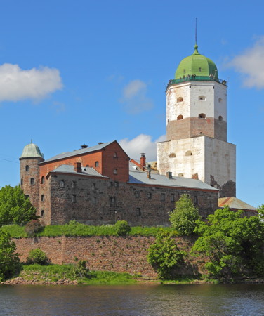
Date unknown (1960s?). Active; focal plane 46 m (151 ft); continuous white light visible only on the range line. Light displayed through a window of the 50 m (165 ft) main tower of Vyborg Castle. A. Savin's photo is at right, a closeup photo is available, Trabas has Klaus Kern's photo, Lightphotos.net also has a closeup, Wikimedia has many other photos, and Google has a street view and a satellite view. The historic fortress of Vyborg was established by the Swedes in the 1290s, but the present main tower, known as the tower of St. Olaf, dates from the 1560s. The fortress is the oldest building in northwestern Russia. Located on a small island adjacent to downtown Vyborg. Site open; castle open for tours, including the tower. . ARLHS ERU-231; Admiralty C5534.1; NGA 13192.
Vyborg Castle
Vyborg Castle, Vyborg, June 2012
Wikimedia Creative Commons photo by A. Savin

Southern Vyborg Bay Lighthouses
Vyborgskiy (Vyborgskaya)
1987. Active; focal plane 14 m (46 ft); two white flashes every 8 s. 10 m (33 ft) octagonal concrete tower with double gallery, painted with red and white horizontal bands, mounted on an octagonal concrete base. Wikimedia has Vladimir Maksimov's photo but the light is not shown in Google's satellite view. This lighthouse stands on a shoal in the middle of the entrance to Vyborg Bay (Vyborgskiy Zaliv) about 7 km (4.3 mi) southeast of Mys Povorotny and 35 km (24 mi) southwest of Vyborg. Accessible only by boat. Site open, tower closed. . ARLHS ERU-319. RU 2201-0712; Admiralty C5505; NGA 13258.
Mys Krestovyy {Ristniemi}
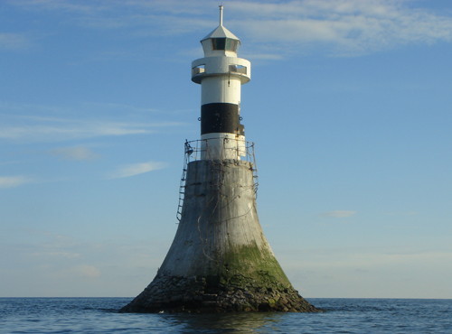
1893. Active; focal plane 14 m (46 ft); flash every 3.5 s, white, red, or green depending on direction. 15 m (49 ft) round cylindrical cast iron tower, painted white with a black horizontal band, mounted on a tall, tapered round concrete and stone pier. A photo is at right, Wikimedia has Vladimir Maksimov's photo but the lighthouse is not shown in Google's satellite view. This is a leading light guiding vessels in both directions on the western approach to Vyborg. The lighthouse stands off Mys Krestovyy, the western entrance to the bay. The two white sectors are shown over the proper approaches from the west and northeast. Located about 3 km (1.8 mi) southeast of the point of the cape. Accessible only by boat. Site and tower closed. . ARLHS ERU-315; Admiralty C5492; NGA 13256.

Gulf of Finland North Side Lighthouses
Dal'nyaya North Range Front (Landyshevyy North Range Front)
Date unknown. Active; focal plane 14 m (46 ft); quick-flashing white light. 11 m (36 ft) skeletal tower, painted red; the tower carries a slatted daymark painted white with a black vertical stripe. Google has a satellite view. Located near the north shore of Dal'nyaya Bay, east of the village of Bolshoy Bor. Site status unknown. Admiralty C5491; NGA 13262.
Dal'nyaya North Range Rear (Landyshevyy North Range Rear)
Date unknown. Active; focal plane 26 m (85 ft); one long white flash every 6 s. 16 m (52 ft) skeletal tower, painted red; the tower carries a slatted daymark painted white with a black vertical stripe. No photo available but Google has a distant satellite view of the location. Located near the north shore of Dal'nyaya Bay, east of the village of Bolshoy Bor. Site status unknown. Admiralty C5491.1; NGA 13263.
Mys Krestovyy Light
Mys Krestovyy Light, July 2007
Wikimapia Creative Commons photo by Oleg
Dal'nyaya West Range Front (Landyshevyy Range Front) {Oritsaari}
Date unknown. Active; focal plane 8 m (26 ft); quick-flashing light, white, red or green depending on direction. 6 m (20 ft) tower with lantern and gallery. No photo available but Google has a satellite view. This range guides vessels on a northeast reach on the western approach to Vyborg Bay in the Gulf of Finland. Located on the southern tip of an island about 4 km (2.5 mi) west of Mys Krestoviy. Accessible only by boat. Site open, tower closed. Admiralty C5490; NGA 13260.
Dal'nyaya West Range Rear (Ostrov Podvesel'nyy, Landyshevyy Range Rear)
Date unknown. Active; focal plane 20 m (62 ft); white light, 2 s on, 2 s off. 17 m (56 ft) skeletal tower, painted red; the tower carries a slatted daymark painted white with a black vertical stripe. No photo available but Google has a satellite view. Located 540 m (1/3 mi) northeast of the front light. Accessible only by boat. Site open, tower closed. ARLHS ERU-217; Admiralty C5490.1; NGA 13261.
Khalli (2)
Date unknown (station established 1911). Active; focal plane 16 m (52 ft); white light, 1.5 s on, 2.5 s off. 12 m (39 ft) square pyramidal skeletal tower, mounted on a square concrete base. Lower porton of the tower painted red, upper portion gray. Lightphotos.net also has Alexey Solovev's more distant view but the lighthouse is not shown in Google's satellite view. Located on an isolated and dangerous rock about 9 km (6.5 mi) south of Malyy Fiskar. Accessible only by boat. Site open, tower closed. Admiralty C5496; NGA 13268.
Malyy Fiskar {Lilla Fiskär}
1909. Active; focal plane 17 m (56 ft); flash every 5 s, white, red, or green depending on direction. 14 m (46 ft) square pyramidal skeletal tower with lantern and gallery. Lighthouse painted red; two sides of the tower carry a slatted daymark painted white. Google has a satellite view. Located at the southwestern tip of Malyy (Little) Fiskar, an island about 10 km (6 mi) southwest of Mys Krestoviy. The island is closed as a nature reserve. Accessible only by boat. Site and tower closed. ARLHS ERU-153; RU 2201-1186; Admiralty C5488; NGA 13264.
Ryabinnik Range Front
Date unknown. Active; focal plane 16 m (52 ft); white light, 1 s on, 1 s off. 15 m (49 ft) skeletal tower, painted red; the tower carries a slatted daymark painted white with a black vertical stripe. No photo available but Google has a satellite view. This range guides vessels on an east-to-west reach after leaving Vyborg Bay. Located on a skerry about 10 km (6 mi) east southeast of Pattso. Site status unknown. Admiralty C5485; NGA 13301.
Ryabinnik Range Rear
Date unknown. Active; focal plane 47 m (154 ft); white light, 2 s on, 2 s off. 37 m (121 ft) skeletal tower, painted red; the tower carries a slatted daymark painted white with a black vertical stripe. No photo available but Google has a satellite view. Located 3.1 km (1.9 mi) west southwest of the front light (next entry). Site status unknown. Admiralty C5485.1; NGA 13302.
Bol'shoy Fiskar {Kiuskeri, Stora Fiskär} (2?)
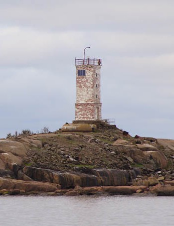
Date unknown (station established 1903). Active; focal plane 21 m (70 ft); two white flashes every 8 s. 10 m (33 ft) square brick tower, supposedly painted red with a white horizontal band. However, in Maksim Antipin's photo (also seen at right) nearly the all the paint has worn off the tower. Google has a satellite view. Located atop a small island at the eastern end of a string of similar islands, the Bol'shoy Fiskar Archipelago, about 24 km (15 mi) west southwest of Mys Krestoviy and 16 km (10 mi) southeast of Virolahti, Finland. Accessible only by boat. Site open, tower closed. ARLHS ERU-212; Admiralty C5482; NGA 13296.
Bol'shoy Fiskar Light
Bol'shoy Fiskar Light, Gulf of Finland, 2007
photo copyright Maksim Antipin; used by permission
Khemminginletto
Date unknown. Active; focal plane 7 m (23 ft); flash every 3.5 s, white, red, or green depending on direction. 5.5 m (18 ft) lantern mounted on a short skeletal tower. Lighthouse painted white with a black horizontal band. No photo available but Google has a fuzzy satellite view. The remaining lights on this page guide smaller vessels in a channel close to the north shore of the Gulf; this passage continues into Finnish waters. Located on a small island off the north shore of the gulf, about 5 km (3 mi) east of the Finnish border. Accessible only by boat. Site open, tower closed. Admiralty C5476; NGA 13300.
Ostrov Kozlinyy {Pukkio} East
Date unknown. Active; focal plane 8 m (26 ft); quick-flashing red light. 6 m (20 ft) lantern mounted on a short skeletal tower. Lantern painted white. No photo available but Google has an indistinct satellite view. Kozlinyy (Pukkio in Finnish) is an island about 1.5 km (1 mi) east of the Finnish border. Located on a pier near the southeastern tip of the island. Accessible only by boat. Site open, tower closed. Admiralty C5474.5.
Ostrov Kozlinyy {Pukkio} West
Date unknown. Active; focal plane 8 m (26 ft); flash every 5 s, white , red, or green depending on direction. 6 m (20 ft) lantern mounted on a short skeletal tower. Lantern painted white. Aleksey Krasovsky's photo is at right and Google has an indistinct satellite view. Located at the southern tip of the island, about 1 km (0.6 mi) southwest of the east light (previous entry). Accessible only by boat. Site open, tower closed. Admiralty C5474; NGA 13304.
Kopytin (Ostrov Kopytin) Range Front
Date unknown. Active; focal plane 22 m (72 ft); quick-flashing white light, visible only on the range line. 16 m (52 ft) square skeletal tower, painted red; the tower also carries a rectangular daymark painted white with a black vertical stripe. No photo available but Google has a fuzzy satellite view. Kopytin is the westernmost island of Russia on the north coast of the gulf. The range guides westbound vessels on a long reach close to the coast. Site status unknown. ARLHS ERU-151; Admiralty C5472; NGA 13308.
Kopytin (Ostrov Kopytin) Range Rear
Date unknown. Active; focal plane 41 m (135 ft); white light, 2 s on, 4 s off, visible only on the range line. 32 m (102 ft) square skeletal tower, painted red; the tower also carries a rectangular daymark painted white with a black vertical stripe. No photo available but Google has an indistinct satellite view. Located 550 m (1/3 mi) west of the front light. Site status unknown. ARLHS ERU-152; Admiralty C5472.1; NGA 13312.
Ostrov Kozlinyy West Light
Ostrov Kozlinyy West Light,Gulf of Finland, July 2010
ex-Panoramio photo copyright Aleksey Krasovsky
permission requested

Information available on lost lighthouses:

Notable faux lighthouses:

Adjoining pages: East: Lake Ladoga | South: St. Petersburg Area | West: Gulf of Finland Islands, Southern Finland: Kymenlaakso

Return to the Lighthouse Directory index | Ratings key

Posted May 22, 2005. Checked and revised August 19, 2023. Lighthouses: 47. Site copyright 2023 Russ Rowlett and the University of North Carolina at Chapel Hill.