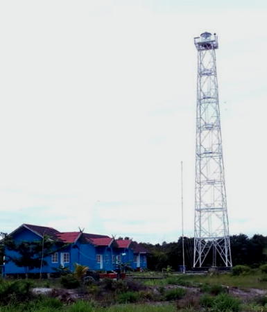
Lighthouses of Indonesia: Central Kalimantan (Borneo)

The Republic of Indonesia has been independent since 1945 after having been the Dutch East Indies for more than 350 years. It is a huge country, stretching along both sides of the Equator for more than 46 degrees of longitude (roughly 5100 km or 3200 miles). Comprised of some 17,000 islands (more than 6000 inhabited islands), it has hundreds of major aids to navigation.

Borneo, known as Kalimantan in Indonesia, is the world's third largest island. 73% of the island is Indonesian; the remaining portion includes the Malaysian states of Sarawak and Sabah and the independent sultanate of Brunei. Indonesian Kalimantan is separated from Sulawesi (Celebes) to the east by the Makassar Strait, from Java to the south by the Java Sea, and from Sumatra to the southwest by the Karimata Strait and Natuna Sea.

Indonesia is divided into 38 provinces (provinsi) and the provinces are subdivided into county units called regencies (kabupaten). This page describes lighthouses of Central Kalimantan Province. As its name implies Central Kalimantan includes much of the interior of the island, but it also has a lengthy coast facing south on the Java Sea.

In Indonesian a lighthouse is a mercusuar or a menara suar. Tanjung is a cape, ujung is a headland or point of land, bukit is a hill, sungai is a river, kuala or muara is an estuary or river mouth, pulau is an island, karang is a reef, batu is a rock, laut is a sea, selat is a strait, teluk is a bay, pelabuhan is a harbor, and labuhan is a port.

Aids to navigation in Indonesia are operated and maintained by the Directorate of Marine Navigation within the Directorate General of Sea Transportation

ARLHS numbers are from the ARLHS World List of Lights. Admiralty numbers are from volumes F and Q of the Admiralty List of Lights & Fog Signals. U.S. NGA List numbers are from Publication 112.

General Sources
Online List of Lights - Indonesia - Kalimantan
Photos by various photographers posted by Alexander Trabas.
Indonesian Lighthouses
Historic postcard views from the collection of Michel Forand.
World of Lighthouses - Indonesia
Photos by various photographers available from Lightphotos.net.
GPSNauticalCharts
Navigational chart information for West Kalimantan.
Navionics Charts
Navigation chart for southern Kalimantan.

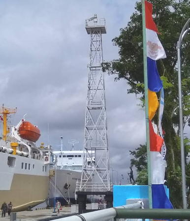
Pelabuhan Kumai Light, Kumai, May 2015
ex-Google Plus photo by Clasic Dyddunia
Kapuas Regency Lighthouses
The Kahayan River, the largest river entirely in Central Kalimantan, is navigable for many miles to the provincial capital of Palangkaraya.

Sungai Kahayan Approach Range Front
Date unknown. Active; focal plane 10 m (33 ft); white flash every 1.5 s. 10 m (33 ft) square skeletal tower, painted white, mounted on a square platform supported by piles. No photo available but Google has a satellite view. The light appears taller than the listed 10 m (33 ft). Located about 400 m (1/4 mi) off the entrance to the Kahayan River. Site status unknown. Admiralty Q1412.5; NGA 25026.
Sungai Kahayan Approach Range Rear
Date unknown. Active; focal plane 18 m (59 ft); white light, 2 s on, 3 s off. Approx. 15 m (49 ft) square skeletal tower, painted white, mounted on a square platform supported by piles. No photo available but Google has a satellite view. Located on the east side of the entrance to the Kahayan River. Site status unknown. Admiralty Q1412.51; NGA 25026.1.
Pulau Mintin
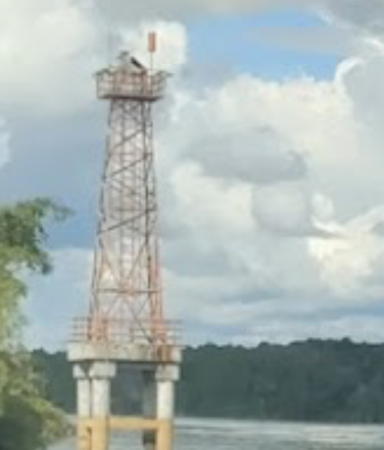
Date unknown. Active; focal plane 12 m (39 ft); red flash every 5 s. 12 m (43 ft) square skeletal tower, painted white, mounted on a square platform supported by piles. Abdu Rahman has the 2021 photo seen at right, Marjo Enzi Setiawan has a distant 2021 photo, and Google has a satellite view. Located off the south point of the island, this light guides ferries crossing the Kahayan River at Mintin, about 70 km (44 mi) upstream from the mouth (this is the first crossing of the river). Easy to see from the ferries. Admiralty Q1412.613.

Pulang Pisau Regency Lighthouse
Gosong Malatayur
Date unknown. Active; focal plane 13 m (43 ft); two white flashes every 10 s. 13 m (43 ft) square skeletal tower, painted white, mounted on a square platform supported by piles. No photo available and Google's satellite view does not show the reef. Located on a shoal about 30 km (19 mi) south of Tanjung Malatayur. Accessible only by boat. Site open, tower closed. Admiralty Q1411.75; NGA 25029.

Katingan Regency Lighthouse
Pulau Buaya
Date unknown. Active; focal plane 18 m (59 ft); white flash every 5 s. 15 m (49 ft) square white skeletal tower on a platform supported by piles. Nathaniel Eferen has a 2024 photo (lighthouse on the right) and Bing has an indistinct satellite view. Located on a reef in Sebangan Bay. Accessible only by boat. Site open, tower closed. Admiralty Q1411.74.

Pulau Mintin Light, Kapuas, November 2021
Google Maps photo by Abdu Rahman
Pulau Batu Mandi
Date unknown. Active; focal plane 18 m (59 ft); white flash every 5 s. 15 m (49 ft) "white beacon," probably a square skeletal tower on a platform supported by piles. No photo available and the light is not shown clearly in Bing's satellite view of the reef. Located on a reef in Sebangan Bay about 2.5 km (1.5 mi) southwest of Pulau Buaya. Accessible only by boat. Site open, tower closed. Admiralty Q1411.73.
Selat Jeruju Range Rear
2019. Active; focal plane 15 m (49 ft); white light, 2 s on, 2 s off. 15 m (49 ft) square white skeletal tower on a platform supported by piles. No photo available but Google has a satellite view. The range guides vessels into the narrow passage separating Pulau Damar from the mainland. The front light is on a much shorter tower with a focal plane of 11 m (36 ft). Located on the north side of the entrance to the strait, on the west side of Sebangan Bay. Accessible only by boat. Site open, tower closed. Admiralty Q1411.63.
Gosong Schunyer
Date unknown. Active; focal plane 13 m (43 ft); white flash every 5 s. 13 m (43 ft) "white beacon," probably a square skeletal tower on a platform supported by piles. No photo available and the light has not been found in Bing's satellite view of the reef. Located off the swampy point between Sebangan Bay and Sampit Bay. Accessible only by boat. Site open, tower closed. Admiralty Q1411.72; NGA 25028.5.

Kotawaringin Timur (East Kotawaringin) Regency Lighthouses
Tanjung Serambut Range Front
Date unknown. Active; focal plane 15 m (49 ft); white light, 1 s on, 1 s off. 15 m (49 ft) square skeletal tower painted white, mounted on a square platform supported by piles. No photo available but Google has a satellite view. This is the entrance range for the Sampit River. Located on the east side of the entrance to the river. Accessible only by boat. Site open, tower closed. Admiralty Q1411.8; NGA 25030.
Tanjung Serambut Range Rear
Date unknown. Active; focal plane 16 m (52 ft); white flash every 4 s. 16 m (52 ft) square skeletal tower painted white, mounted on a square platform supported by piles. No photo available but Google has a satellite view. Located on the river bank about 120 m (400 ft) north of the front light. Site status unknown. Admiralty Q1411.85; NGA 25030.1.
Sukajadi Sawit Mekar
Date unknown. Active; focal plane 15 m (49 ft); white flash every 5 s. Approx. 12 m (39 ft) square white skeletal tower. No photo available but Bing's satellite view probably locates the light. Located at an industrial port on the west bank of the lower Sampit River about 2.5 km (1.5 mi) southwest of the Bagendang light. Site and tower closed. Site and tower closed. Admiralty Q1411.9.
Bagendang Harbor (Pelabuhan Bagendang)
Date unknown. Active; focal plane about 27 m (89 ft); white light, pattern unknown. Approx. 25 m (82 ft) square white skeletal tower. A distant view is available and Bing has a satellite view. Located at a container and petroleum port on the west bank of the lower Sampit River about 10 m (6 mi) from the sea. Located on the waterfront of the harbor. Site open, tower closed. Admiralty Q1412.2.
* Sampit (Pelabuhan Sampit)
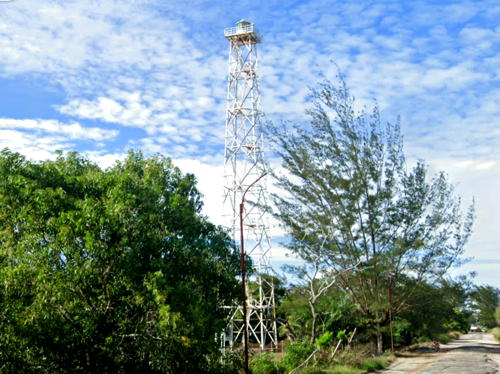
Date unknown. Active; focal plane about 27 m (89 ft); white light, pattern unknown. Approx. 25 m (82 ft) square white skeletal tower. A 2017 street view (also seen at right) is available, Wahyu Zulianto has a closeup photo, and Google has a 2023 street view (seen at right) and a satellite view. Sampit is a former timber port with a population of about 170,000, located on the west bank of the Sampit River about 20 km (13 mi) from the sea. Located on the town waterfront. Site open, tower closed. Admiralty Q1412.4.
 

Sampit Light, Kotawaringin Timur, September 2023
Google Maps street view
Tanjung Bandaran
Date unknown. Active; focal plane 15 m (49 ft); white flash every 4 s. 15 m (49 ft) skeletal tower, painted white. No photo available but Bing has a satellite view of the tower. Located at the end of a spit on the west side of the entrance to Sampit Bay. Site status unknown. Admiralty Q1411.6; NGA 25032.
* Ujung Pandaran
2007 (?). Active; focal plane 43 m (141 ft); white flash every 5 s. 40 m (131 ft) square skeletal tower with lantern and gallery. Half a dozen coast guard buildings. Entire lighthouse painted white. Google has a street view and Bing has a satellite view of the station. Located near the base of the spit on the west side of the entrance to Sampit Bay. Site open, tower closed. Admiralty Q1411.5.

Seruyan Regency Lighthouse
Tanjung Siamok
Date unknown. Active; focal plane 20 m (66 ft); two quick white flashes every 5 s. 15 m (49 ft) skeletal tower, painted white, mounted on a square platform supported by piles. Jito Djail's 2017 photo is at right, Tata Deno has a 2016 photo, and Google has a fuzzy satellite view. Located on the west side of the entrance to the Seruyan River, which leads to the river port of Kuala Pembuang, about 25 km (15 mi) southeast of Segintong. Accessible only by boat but easily seen from shore. Site open, tower closed. Admiralty Q1411.4; NGA 25036.

Tanjung Siamok Light, Seruyan, March 2017
ex-Google Plus photo by Jito Djail

Kotawaringin Barat (West Kotawaringin) Regency Lighthouses
Tanjung Puting
Date unknown. Active; focal plane 31 m (102 ft); three white flashes every 14 s. Approx. 28 m (92 ft) tapered square skeletal tower with gallery, painted white. Three 1-story coast guard station buildings. No photo available but Google has a satellite view of the station. Tanjung Putung is a prominent cape about 55 km (35 mi) southwest of Segintong. Site status unknown. Admiralty Q1411.2; NGA 25040.
Gosong Sangora (Sangora Banks)
Date unknown. Active; focal plane 10 m (33 ft); green flash every 5 s. 10 m (33 ft) green beacon, presumably a skeletal or barbell-shaped tower on a platform supported by piles. No photo available and the light is not shown in Google's satellite view. The light guides around a dangerous shoal en route to Kumai Bay. Located about 25 km (15 mi) off the west coast of the Tanjung Puting peninsula. Accessible only by boat. Site open, tower closed. Admiralty Q1411.22; NGA 25042.
Teluk Pangerangan Range Rear
Date unknown. Active; focal plane 16 m (52 ft); white light, 2 s on, 2 s off. 16 m (52 ft) "white beacon," probably a square skeletal tower on a platform supported by piles. No photo available and the light may be too new to appear in Bing's satellite view. This is the second range for vessels in Kumai Bay and the Kumai River. The Admiralty lists it as the Gosong Berasbasah Range, but the range has nothing to do with that shoal. Located off the east bank of the estuary. Accessible only by boat. Site open, tower closed. Admiralty Q1411.31; NGA 25047.1.
* Pelabuhan Kumai (Kumai Port)
Date unknown. Active; focal plane about 24 m (79 ft); white flash every 23 s. Approx. 20 m (66 ft) square skeletal tower with gallery, painted white. Clasic Dyddunia has a photo (also seen at the top of this page), Saeful Anwar has a distant view across the river, and Google has a street view and a satellite view. Located on the waterfront at Kumai, a port on the Kumai River. Site open, tower closed. Admiralty Q1411.36.
Kubu Range Front
Date unknown. Active; focal plane about 13 m (43 ft); white light, pattern unknown. Approx. 13 m (43 ft) square white skeletal tower mounted on a platform supported by piles. No photo available but Google has a fuzzy satellite view. This is an entrance range for Kumai Bay and the Kumai River. Located about 600 m (3/8 mi) offshore on the northwest side of the bay. Accessible only by boat. Site open, tower closed. Admiralty Q1411.28.
Kubu Range Rear
Date unknown. Active; focal plane about 22 m (72 ft); white light, pattern unknown. Approx. 22 m (72 ft) square white skeletal tower mounted on a platform supported by piles. No photo available but Google has a satellite view. Located about 200 m (220 yd) offshore on the northwest side of the bay. Accessible only by boat. Site open, tower closed. Admiralty Q1411.29.
Tanjung Kluang (Keluang) Range Rear
Date unknown. Active; focal plane about 16 m (52 ft); white light, pattern unknown. Approx. 16 m (52 ft) square white skeletal tower mounted on a platform supported by piles. No photo available but Bing has a fuzzy satellite view. This range guides vessels leaving Kumai. Located just offshore at the southern end of Kumai Bay. Accessible only by boat. Site open, tower closed. Admiralty Q1411.247.
Tanjung Kluang (Keluang)
Date unknown. Active; focal plane 12 m (39 ft); white flash every 5 s. 12 m (39 ft) skeletal tower, painted white. A 2019 photo is at right, the lighthouse is seen at lower left in a drone view by Syahlan Siregar, and Google has an indistinct satellite view. Located near the end of a long spit on the west side of the entrance to Kumai Bay. Site status unknown. Admiralty Q1411.25; NGA 25046.

Tanjung Kluang Light, Kotawaringin Barat, February 2019
Google Maps photo by Martian Magnamesia
Tanjung Pandan
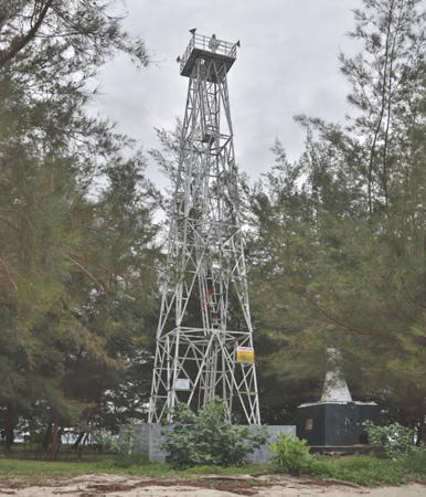
Date unknown. Active; focal plane about 45 m (148 ft); white light, pattern unknown. 40 m (131 ft) square white skeletal tower with lantern and gallery. Three 1-story coast guard station buildings. Dino Akbar has a 2017 photo (also seen at right) and Google has a satellite view. Located about 8 km (5 mi) southwest of Tanjung Kluang. Site status unknown. Admiralty Q1411.245.
Gosong Berasbasah (Wet Rice Shoal)
Date unknown. Active; focal plane 13 m (43 ft); white flash every 5 s. 13 m (43 ft) "white beacon" mounted on a platform supported by piles. No photo available and Google's satellite view does not show the shoal. This light marks the end of a long, dangerous shoal extending southward from Tanjung Pengujan. Located about 8 km (5 mi) south of the cape. Accessible only by boat. Site open, tower closed. Admiralty Q1411.24; NGA 25043.
Tanjung Putri
Date unknown. Active; focal plane 13 m (43 ft); red flash every 5 s. 13 m (43 ft) square red skeletal tower on a platform supported by piles. No photo available but Google has a satellite view. Located just off Tanjung Putri, the headland on the west side of the entrance to the Sekonyer River. Accessible only by boat. Site open, tower closed. Admiralty Q1411; NGA 25044.
Pulau Batimbal
Date unknown. Active; focal plane about 13 m (43 ft); green light, pattern unknown. Approx. 13 m (43 ft) square green skeletal tower on a platform supported by piles. Lebay Abai has a 2023 photo, a distant photo is available, and Google has a satellite view. Located just off the southern tip of an island in the lower Sekonyer River. Accessible only by boat. Site open, tower closed. Admiralty Q1411.13.
Pulau Bengaris (Bengaris Bank)
Date unknown. Active; focal plane about 13 m (43 ft); green light, pattern unknown. Approx. 13 m (43 ft) square green skeletal tower on a platform supported by piles. No photo available but Google has a satellite view. Located just off the southern tip of an island in the lower Sekonyer River, about 8 km (5 mi) upstream from the Pulau Batimbal light. Accessible only by boat. Site open, tower closed. Admiralty Q1411.15.

Tanjung Pandan Light, Kotawaringin Barat, November 2017
Google Maps photo by Dino Akbar

Sukamara Regency Lighthouses
* Selaka Cape (Tanjung Nipah)
Date unknown. Active; focal plane about 75 m (246 ft); white light, pattern unknown. Approx. 48 m (157 ft) octagonal skeletal tower, covered with white panels, with lantern and gallery. A YouTube video uploaded in 2020 has an excellent drone view between the 1:00 and 2:00 marks and Martinus Liem has a distant view, but the lighthouse is not seen in Bing's satellite view. Ari Thor has a March 2021 photo showing a large number of the siding panels removed. Located atop a forested dune west of the village of Tanjung Nipah. Site open, tower status unknown. Admiralty Q1410.7.
* Pelabuhan Jelai (Jelai Port)
Date unknown. Active; focal plane about 20 m (66 ft); light characteristic unknown. Approx. 17 m (56 ft) square skeletal tower with gallery, painted white. The light is near the left edge of Ahmad Gunawan's photo and Google has an indistinct satellite view. Located on the waterfront at Jelai, a port on the Jelai-Bila River, which forms part of the border between Central Kalimantan and West Kalimantan. Site open, tower closed. Admiralty Q1410.63.

Information available on lost lighthouses:

Notable faux lighthouses:

Adjoining pages: East: South Kalimantan | Northwest: West Kalimantan

Return to the Lighthouse Directory index | Ratings key

Posted December 9, 2008. Checked and revised May 30, 2024. Lighthouses: 31. Site copyright 2024 Russ Rowlett and the University of North Carolina at Chapel Hill.