Lighthouses of Japan: Tottori and Tajima

The nation of Japan, known in Japanese as Nihon or Nippon (日本), occupies an archipelago off the east coast of Asia. The four main islands are Hokkaidō in the north, Honshū (the largest) in the center, Shikoku in the south, and Kyūshū in the southwest. The country includes thousands of other islands of all sizes; among them the Ryūkyū (Nansei) Islands are a long chain extending to the southwest and including the large island of Okinawa, and the Nanpō Islands are another long chain extending south into the Pacific Ocean. Much of Japan is mountainous but the coastal regions are densely populated and urbanized; the country's population is about 126 million.

Japan is divided into 47 prefectures. This page lists lighthouses of the Sea of Japan coast of the principal island of Honshū, including Tottori Prefecture and the adjoining north coast of Hyōgo Prefecture, known historically as Tajima. This is a rugged and beautiful coast with many small ports but only a few big ones. Sakai (Sakaiminato) in far western Tottori Prefecture is the most important. The area is only lightly populated; Tottori is the least populous of Japan's prefectures.

In Japanese the word for a lighthouse is tōdai or toudai (灯台). The words saki and misaki are for capes and headlands, hana ("nose") is a promontory, hantō is a peninsula, shima (also spelled sima or jima) is an island, bae is a reef, iwa or shi is a rocky reef, amase or se is a shoal, wan is a bay, nada is a sound or basin, kaikyō is a strait, kawa is a river, and or minato is a harbor.

Lighthouses in Japan are operated and maintained by the Japanese Coast Guard's Maritime Safety Agency. There is usually at least one Coast Guard Section Office in each prefecture, often two or more. In Tottori there is one office at Sakaiminato. Lights on the rather short northern coast of Hyōgo are maintained by the office at Maizuru in neighboring Kyōto prefecture.

A note on the Sea of Japan/East Sea controversy: The Directory takes no side in any international dispute; it makes use of the terminology, names, and spellings as they currently exist in each area covered. The sea between Japan and Korea is called the Sea of Japan on the pages for Japan and the East Sea on the pages for Korea.

ARLHS numbers are from the ARLHS World List of Lights. JCG numbers are the Japanese Coast Guard's light list numbers. Admiralty numbers are from volume M of the Admiralty List of Lights & Fog Signals. U.S. NGA List numbers are from Publication

General Sources
Lighthouses in Japan - Tottori and Hyōgo
A Japanese-language site covering the major lighthouses throughout the country.
Lighthouse-Japan.com - Tottori and Hyōgo
Excellent photos with notes (in Japanese) for many of the lighthouses.
Form of a Lighthouse - Tottori and Hyōgo
Another site with many photos of Japanese lighthouses, cited below as FOAL.
Lighthouse Visit
Another fine source of lighthouse photos.
Online List of Lights - Japan
Photos by various photographers posted by Alexander Trabas.
Misty's Japanese Lighthouse Tour - Tottori and Hyōgo
Photos and a few notes for lighthouses in all parts of the country.
Sakaiminato Area Lighthouses
Photos posted by the Sakai Coast Guard Office.
Lighthouses in Tottori Prefecture and Lighthouses in Hyōgo Prefecture
Photos by various photographers available from Wikimedia.
Navionics Charts
Navigation chart for southwestern Honshū.
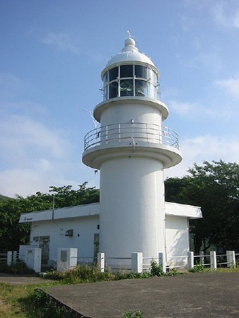
Amurabe Saki Light
Amarube Saki Light, Kasumi, Hyōgo, 2006
Wikimedia Creative Commons photo by Jnn
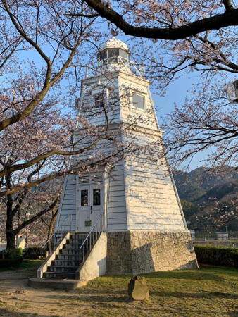

Sakai Light, Sakaiminato, Tottori, April 2021
Instagram photo by totesan21

Lighthouses of Tottori Prefecture

Sakaiminato City Lighthouses
Sakaiminato is a city of about 35,000 residents at the west end of Tottori Prefecture. Generally know as Sakai, the city is the largest fishing port of western Honshū and an important center for seafood processing.
* Sakai Kō Directional Light
1982. Active; focal plane 18 m (59 ft); white, red or green light, depending on direction, shown only along or close to the range line; also a yellow light, 1 s on, 1 s off. 20 m (66 ft) round cylindrical tower, painted with red and white horizontal bands. Lighthouse-Japan.com has a page with good photos, FOAL's page has several photos, Lighthouse Visit also has a page, Trabas has a closeup photo, and Google has a street view and a satellite view. The range guides vessels in the channel separating Sakai from Jizo Saki in Shimane Prefecture. Located on the waterfront about 600 m (3/8 mi) west of the Mihonoseki Bridge. Site open, tower closed. . JCG-0901; Admiralty M7296; NGA 2184.
** Sakai (replica)
1991 replica of 1895 lighthouse. Inactive (?). 9 m (30 ft) hexagonal wood tower with lantern and gallery. Lighthouse painted white. A 2021 photo is at the top of this page, FOAL's page has photos (bottom of the page), Toshio Aoto has a 2023 photo, a 2016 photo is available, and Google has a street view and a satellite view. The original Sakai lighthouse, demolished in 1965, was a shorter version of an 1877 lighthouse near Ōsaka, which by coincidence is also called Sakai Light. The replica is located in a small park just off the waterfront of the channel separating Sakai from Jizo Saki, about 200 m (220 yd) west of the Mihonoseki Bridge. Site open, tower open on weekends in March, April, May, July and August. .
* Sakai Kō South Breakwater
Date unknown. Active; focal plane 13 m (43 ft); white light, 3 s on, 3 s off. 14 m (46 ft) round concrete tower with lantern and gallery. Entire lighthouse is white. A photo is at right, Trabas has a closeup photo, Lighthouse-Japan.com has a page with several photos, a 2013 photo shows a cruise ship passing the lighthouse, the Coast Guard has a photo (second photo on the page), FOAL's page and the Lighthouse Visit page have photos of both breakwater lights, and Google has a satellite view and a distant street view. Sakaiminato is located on a broad spit separated from the Jizo Saki peninsula by a narrow channel that is the inlet to a protected lagoon behind the spit. The channel is the border between Tottori and Shimane Prefectures. Located at the end of a short jetty (not really a breakwater) on the south side of the inlet. Site and tower closed, but the lighthouse can be seen easily from shore. . ARLHS JPN-322; JCG-0897; Admiralty M7294; NGA 2180.
Sakai Kō (Outer Breakwater)
Date unknown. Active; focal plane 16 m (52 ft); green flash every 3 s. 14 m (46 ft) round concrete tower with flared top and gallery. Entire lighthouse is white. Trabas has a closeup photo, Lighthouse-Japan.com has a photo, FOAL's page and the Lighthouse Visit page have photos of both breakwater lights, and Google has a satellite view and a distant street view. This light is actually southeast of the so-called South Breakwater Light, and the main entrance to Sakai harbor is between the two lights. Located at the north end of the detached outer breakwater of Sakai. Accessible only by boat. Site and tower closed. ARLHS JPN-527; JCG-0897.4; Admiralty M7294.5; NGA 2182.

Yonago City Lighthouse
* Yodoe Kō
1970. Active; focal plane 13 m (43 ft); green light, 2 s on, 2 s off. 8 m (26 ft) round concrete post attached to a 1-story concrete equipment building. Entire lighthouse is white. Lighthouse Visit has a page for the light, FOAL has a page, Trabas has a closeup photo, and Google has a distant street view and a satellite view. Located at the end of the breakwater pier of Yodoe harbor in Yanago, the city adjoining Sakaiminato to the east. Accessible by walking the pier. Site open, tower closed. ARLHS JPN-1601; JCG-0921; Admiralty M7293.5; NGA 2216.

Daisen Town Lighthouse
* Misaki Kō
1970. Active; focal plane 15 m (49 ft); red light, 2 s on, 2 s off. 10 m (33 ft) round concrete post attached to a 1-story concrete equipment building. Entire lighthouse is red. Lighthouse Visit has a page for the light, Trabas has a closeup photo, and Google has a street view and a satellite view. FOAL's page shows the lighthouse under restoration in 2018. Located at the end of the north (main) breakwater of Misaki harbor, at a prominent cape in central Tottori. Accessible by walking the pier. Site open, tower closed. ARLHS JPN-1591; JCG-0924; Admiralty M7292; NGA 2224.

Sakai Kō South Breakwater Light, Sakaiminato, March 2021
Google Maps photo by 西田 (Nishida)

Kotoura Town Lighthouse
Akasaki Kō
Date unknown. Active; focal plane 15 m (49 ft); red flash every 3 s. 9.5 m (31 ft) round concrete post attached to a 1-story concrete equipment building. Entire lighthouse is red. Trabas has a closeup photo, Lighthouse Visit has a page for the light, FOAL also has a page, and Google has a satellite view and a distant street view. Located on the west outer breakwater of Akasaki harbor in Kotoura. Accessible by walking the pier. Accessible only by boat. Site open, tower closed. ARLHS JPN-1597; JCG-0925; Admiralty M7290.2; NGA 2232.

Yurihama Town Lighthouse
 
* Tomari
1972. Active (?); focal plane 35 m (115 ft); white flash every 4 s; also a continuous white spotlight (JCG-0928) illuminates a nearby reef. 10 m (33 ft) round concrete post centered on a 1-story concrete equipment building. Entire lighthouse is white. Trabas has a closeup photo, Lighthouse-Japan.com has a page with several photos, Lighthouse Visit also has a page for the light, FOAL's page has photos (bottom of the page), Yukihiro Matsumura has a 2023 photo, Misty's Tour has a small photo, and Google has a satellite view. FOAL reports that this light was deactivated in October 2019 but it remains on the Admiralty list. Located on heights above the waterfront at Tomari, in Yurihama about 25 km (15 mi) west of Tottori. Site open, tower closed. . ARLHS JPN-668; JCG-0927; Admiralty M7289.2; NGA 2236.

Tottori City Lighthouses
Tottori, the capital of the prefecture, is a city with a population of nearly 200,000. On the east side of the city is an area of sand dunes, a rare sight in Japan.

* Nagao Hana (2)
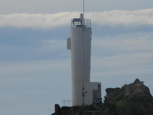
1991 (station established 1927). Active; focal plane 68 m (223 ft); white flash every 8 s. 13.5 m (45 ft) round cylindrical concrete tower with lantern and gallery, attached to a 1-story equipment shed. Entire lighthouse is white. Ken Ichi Mori's 2022 photo is at right, Trabas has a closeup photo, Lighthouse-Japan.com has a page with several photos, FOAL also has a page, Lighthouse Visit also has photos (lower half of the page), S. Morita has a good photo, and Google has a satellite view. The station is surrounded by the Nishiinaba Prefectural Natural Park. Located on a sharp, isolated promontory about 3 km (2 mi) northeast of Aori; this cape is a significant hazard to navigation along the coast. Accessible by an unsealed road; parking provided. Site gated, but the lighthouse can be seen from nearby. . ARLHS JPN-389; JCG-0934; Admiralty M7289; NGA 2256.
Sakenotsu
1957. Active; focal plane 59 m (194 ft); white flash every 3 s. 7.5 m (25 ft) round concrete post attached to a 1-story concrete equipment building. Entire lighthouse is white. Lighthouse Visit has photos (lower half of the page), FOAL also has photos (lower half of the page), Trabas has a closeup, a 2023 closeup is available, Ken Nishimoto Ke has a distant view, and Google has a satellite view. Located atop a steep hill southeast of the harbor of Sakenotsu; the coastal highway tunnels under this hill. Site open, but the author of Lighthouse-Japan.com had trouble finding it; tower closed. ARLHS JPN-531; JCG-0938; Admiralty M7288.6; NGA 2264.

Nagao Hana Light, Tottori, May 2022
Instagram photo by Ken Ichi Mori
Tottori Kō (Toriga Shima)
1983. Active; focal plane 32 m (105 ft); white light, 3 s on, 3 s off. 11 m (36 ft) round concrete tower with a flared top, attached to a small equipment shelter. Entire lighthouse is white. Yukihiro Matsumura's 2023 photo is at right, Lighthouse-Japan.com has a page with good photos, Lighthouse Visit has photos (halfway down the page), FOAL's page has photos (second photo on the page and 4/5 the way down the page), Trabas has a closeup, and Google has a distant street view and a satellite view. Wataru Kishimoto's photo shows the steep approach to the lighthouse. Located on a rocky islet just off the waterfront of Tottori. Accessible with caution over breakwaters extending from the west quay. Site open, tower closed. . ARLHS JPN-682; JCG-0939.5; Admiralty M7287.5; NGA 2276.
Tottori Kō Outer Breakwater
Date unknown. Active; focal plane 17 m (56 ft); red flash every 4 s. 12 m (39 ft) round concrete tower with a flared top, attached to a small equipment shelter. Entire lighthouse is red. Lighthouse Visit has photos (top of the page), FOAL's page has a photo (halfway down the page, on the left), Trabas has a closeup, and Google has a satellite view. Located at the end of Tottori's outer breakwater. Accessible only by boat. Site and tower closed. ARLHS JPN-1598; JCG-0938.9; Admiralty M7287.7; NGA 2280.
Tottori Kō East Breakwater
1990. Active; focal plane 13 m (43 ft); continuous green light with a more intense flash every 4 s. 8.5 m (28 ft) round hourglass-shaped concrete tower. Entire lighthouse is white. Lighthouse Visit has photos (bottom of the page), FOAL's page has a photo (halfway down the page, on the right), Trabas has a closeup, and Google has a satellite view. Located at the end of Tottori's east breakwater. Accessible only by boat. Site and tower closed. ARLHS JPN-1596; JCG-0941; Admiralty M7287.6; NGA 2286.

Toriga Shima Light, Tottori, July 2023
Instagram photo by Yukihiro Matsumura

Iwami Town Lighthouses
* Ajiro (Aziro) Saki
1950. Active; focal plane 105 m (344 ft); white flash every 12 s. 11 m (36 ft) round concrete tower with lantern and gallery. Entire lighthouse is white. A2019 photo is at right, Trabas has a closeup photo, Lighthouse-Japan.com has a page with good photos, Lighthouse Visit has photos (halfway down the page), FOAL also has a page with photos, Misty's Tour has a photo, and Google has a satellite view. Located on a promontory about 12 km (7.5 mi) northeast of Tottori. Accessible by a hiking trail, but parking is very limited. Site open, tower closed. . ARLHS JPN-038; JCG-0946; Admiralty M7286; NGA 2296.
* Tajiri (Taziri)
1950. Active; focal plane 33 m (108 ft); white light occulting once every 4 s. 9 m (30 ft) round concrete post centered on a 1-story concrete equipment building. Entire lighthouse is white. Yukihiro Matsumura has a 2023 closeup, Lighthouse-Japan.com has a page with several photos, Lighthouse Visit has photos (top of the page), the FOAL page for Tajiri has photos, Trabas has a photo, and Google has a satellite view and a very distant street view. Located on an islet protecting the harbor at Tajiri, about 15 km (9 mi) northeast of Tottori; the islet is accessible from the town's main breakwater. Site open, tower closed. . ARLHS JPN-636; JCG-0947; Admiralty M7283.9; NGA 2308.
Tajiri (Taziri) U Shima
Date unknown. Active; focal plane 14 m (46 ft); red flash every 3 s. 9 m (30 ft) round concrete post attached to a 1-story concrete equipment building. Entire lighthouse is red. The FOAL page for Tajiri has photos, Lighthouse Visit has photos (bottom of the page), Trabas has a photo, and Google has a satellite view. Located on a rocky reef just beyond the end of the main Tajiri breakwater. Accessible only by boat. Site open, tower closed. ARLHS JPN-1599; JCG-0949; Admiralty M7283.94; NGA 2316.
Ōbaneo
Date unknown. Active; focal plane 75 m (246 ft); white light, 4 s on, 4 s off. 7.5 m (25 ft) round concrete tower, attached to a 1-story concrete equipment room. Entire lighthouse is white. Lighthouse Visit has a page for the lighthouse, a 2023 closeup is available, FOAL has distant views, Trabas has a drone view, and Google has a satellite view. Located on a promontory about 3 km (2 mi) northeast of Tajiri. The road to the lighthouse is reported closed, and access to the site is difficult. Site and tower closed. ARLHS JPN-449; JCG-0950; Admiralty M7283.85; NGA 2320.

Ajiro Saki Light, Iwami, November 2019
Google Maps photo by 山旅バイカー (mountain trip biker)

Lighthouses of Northern Hyōgo Prefecture

Hyōgo Prefecture spans the width of Honshū. The northern portion of the prefecture, facing the Sea of Japan, was known historically as Tajima Province. Lighthouses of Hyōgo's southern coast, on the Seto Inland Sea, are listed on the Kōbe Area, Himeji Area, and Awaji Shima pages.

Shin'onsen Town Lighthouses
Ikumi (Igumi)
Date unknown. Active; focal plane 66 m (217 ft); white flash every 5 s; also a continuous white spotlight (JCG-0952) illuminates a nearby reef. 11 m (36 ft) round concrete tower with a flared top topped by a square enclosure. Entire lighthouse is white. Trabas has a good photo, a 2022 photo is available, FOAL has a distant view (second row, right) and Google has a satellite view. Located atop a rocky islet off the waterfront of Ikumi. Accessible only by boat. Site and tower closed. . ARLHS JPN-1499; JCG-0951; Admiralty M7283.8; NGA 2328.
Ikumi (Igumi) Entrance
Date unknown. Inactive. 10 m (33 ft) concrete post attached to a 1-story concrete equipment shelter. Entire lighthouse is white. Lighthouse Visit has a photo (top of the page), FOAL has a photo (last row, left) and Google has a satellite view. The Lighthouse Visit webmaster has confused this light with the previous entry. The light is not charted as active by Navionics. Located at the end of a rocky reef that forms a natural breakwater northwest of the main Ikumi light (previous entry). May be accessible only by boat. Site status unknown. Not listed by JCG or by the Admiralty.
* Moroyose (Hiyori Yama, Hiwayama) (2)
1986 (station established 1956). Continuous white spotlight illuminates a nearby reef. 9 m (30 ft) round cylindrical concrete tower. Entire lighthouse is white. Trabas has a photo, a 2022 photo and a 2022 drone view are available, Lighthouse-Japan.com has a page with good photos, Lighthouse Visit has a page with photos (top of the page), FOAL's page has closeup photos (middle of the page), Misty's Tour has a small photo, and Google has a satellite view. The general purpose light at the top of the tower was deactivated in 2011 (ex-JCG-0955, ex-Admiralty M7283.6), but the spotlight remains active. Located on the heights above the harbor of Moroyose. Accessible by a hiking trail, but local guidance may be needed. Site open, tower closed. JCG-0956.1; Admiralty M7283.62; NGA 2332.

Ikumi Light, Shin'onsen, June 2022
Instagram photo by Yukihiro Matsumura
Moroyose (Hiyori Yama) Breakwater
Date unknown. Active; focal plane 13 m (43 ft); red light, 3 s on, 3 s off. 8.5 m (28 ft) concrete post attached to a 1-story concrete equipment shelter. Entire lighthouse is red. Lighthouse Visit has a page with a photo (bottom of the page), FOAL's page has closeup photos (bottom of the page), Trabas has a closeup, a 2022 photo is available, and Google has a satellite view. This light has been relocated recently from the north inner breakwater, where it appears in the 2010 photo from FOAL. Located on the outer breakwater of Moroyose harbor. Site status unknown. JCG-0957; Admiralty M7283.7; NGA 2336.
* Hamasaka (Yashiro Ga Hana, Yajoga Hana)
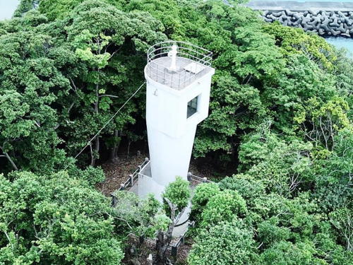
1972. Active; focal plane 74 m (243 ft); white light occulting twice every 6 s. 10 m (33 ft) round cylindrical concrete tower, attached to a 2-story equipment shelter (an inactive spotlight in the upper story formerly illuminated on a nearby reef). Entire lighthouse is white. Trabas has a good drone view, Lighthouse-Japan.com has a page with photos, Lighthouse Visit has photos (top of the page), FOAL's page has photos, Misty's Tour has photos, Naoyuki Sakai has a distant view from the beach, and Google has a satellite view and the lovely street view seen at right. NGA lists the light as Yazyoga Hana. Located on a promontory at Hamasaka, about 3 km (2 mi) east of Moroyose. Accessible by a short walk from the harbor along a forested ridge. Site open, tower closed. ARLHS JPN-1547; JCG-0958; Admiralty M7283.57; NGA 2340.
* Hamasaka Kō North Detached Breakwater
Date unknown (station established 1960). Active; focal plane 13 m (43 ft); red light occulting once every 4 s. 10 m (33 ft) round concrete tower attached to a small equipment shelter. Entire lighthouse is red. Trabas has a good photo, FOAL's page has 2018 photos (bottom of the page), Lighthouse Visit has 2016 photos (middle of the page), and Google has a satellite view. This light replaced the North (Inner) Breakwater Light seen in Lighthouse-Japan's 2008 photo. NGA misspells the name of the town "Hamaska." Located at the east end of the north detached breakwater at the entrance to Hamasaka harbor. Accessible by walking the pier. Site open, tower closed. JCG-0959; Admiralty M7283.58; NGA 2348.
Hamasaka Kō Northeast Detached Breakwater
Date unknown. Active; focal plane about 13 m (43 ft); green light, characteristic unknown. Approx. 10 m (33 ft) post centered on a square 1-story equipment shelter. Entire lighthouse is white. Trabas has a good photo, FOAL's page has photos (bottom of the page), Lighthouse Visit has photos (bottom of the page), and Google has a satellite view. Located at the west end of the northeast breakwater. Accessible only by boat. Site open, tower closed. JCG-0960; Admiralty M7283.59; NGA 2344.
Mio Oshima
Date unknown. Active; focal plane 71 m (233 ft); white flash every 4 s. 8.5 m (28 ft) round cylindrical concrete tower with gallery adjoining a 1-story equipment building. Entire lighthouse is white. Trabas has a drone view, FOAL has a distant view (halfway down the page), a 2022 view and another distant view (fourth photo on the page) are available, and Google has a satellite view. Located on a small island off Mio, a tiny village about 15 km (9 mi) northwest of Hamasaka. Accessible only by boat. Site status unknown. ARLHS JPN-357; JCG-0961; Admiralty M7283.52; NGA 2352.

Hamasaka Light, Shin'onsen, April 2019
Google Maps street view

Kami Town Lighthouses
* Amarube Saki (2)
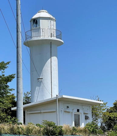
1985 (station established 1951). Active; focal plane 284 m (932 ft); white flash every 15 s. 14 m (46 ft) round cylindrical concrete tower with lantern and gallery, attached to a 1-story equipment building. 2nd order Fresnel lens in use. Entire lighthouse is white. A photo is at the top of this page, Lighthouse-Japan.com has photos, Lighthouse Visit has a page with photos, FOAL has excellent photos, Misty's Tour also has a photo, and Google has a closeup street view and a satellite view of the station. NGA lists an "octagonal metal tower," which may describe the original lighthouse. This is Japan's highest lighthouse. Located on a prominent cape about 10 km (6 mi) west of Kasumi. Accessible by a twisting mountain highway; parking provided. Site open, tower closed. . ARLHS JPN-019; JCG-0963; Admiralty M7283.5; NGA 2360.
* Shiroyama South Breakwater
Date unknown. Active; focal plane 11 m (36 ft); red light, 2 s on, 2 s off. 10 m (33 ft) round red concrete tower mounted on a large square concrete base. FOAL has a photo (second row, left), Lighthouse Visit has photos (top of the page), Trabas has a photo, and Google has a street view and a satellite view. Located at the end of the south breakwater of Kasumi's Shiroyama harbor. Site status unknown. ARLHS JPN-1532; JCG-0967; Admiralty M7282; NGA 2392.
* Shiroyama North Breakwater (2?)
Date unknown (station established 1949). Active; focal plane 13 m (39 ft); green flash every 3 s. 10 m (33 ft) round hourglass-shaped white concrete tower. FOAL has a photo (second row, right), Lighthouse Visit has photos (second lighthouse on the page), Trabas has a photo, a good 2016 photo is available, and Google has a street view and a satellite view. NGA formerly listed an octagonal tower for this light. Located at the end of the north breakwater of Kasumi's Shiroyama harbor. Accessible by walking the pier. Site open, tower closed. ARLHS JPN-1531; JCG-0968; Admiralty M7283; NGA 2396.
* Kasumi Kō
1949. Active; focal plane 88 m (289 ft); white light, 3 s on, 3 s off. 6.5 m (21 ft) concrete post adjoining a 1-story concrete equipment shed. Entire lighthouse is white. Lighthouse-Japan.com has a page with photos, Lighthouse Visit has photos (last lighthouse on the page), FOAL has photos (middle of the page), Trabas has a photo, a 2022 closeup is available, Misty's Tour has a photo, and Google has a satellite view. Located on a steep bluff on the east side of the entrance to Kasumi harbor. Accessible by a short, steep trail, but local guidance will be needed. Site open, tower closed. ARLHS JPN-242; JCG-0969; Admiralty M7281; NGA 2376.
Kasumi Kō Main Breakwater
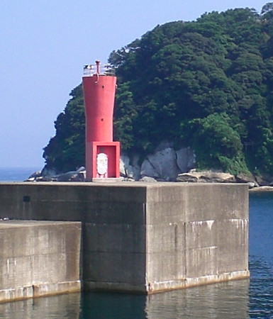
Date unknown. Active; focal plane 17 m (56 ft); continuous red light with a more intense flash every 4 s. 9.5 m (31 ft) round concrete tower with a flared top, attached to a small equipment shelter. Entire lighthouse is red. A photo is at right, FOAL has a photo (second row, left), Trabas has a photo, a 2022 closeup is available, and Google has a satellite view and a very distant street view. Located at the end of the main breakwater of the newer harbor of Kasumi. Probably accessible by walking the pier. Site open, tower closed. ARLHS JPN-1502; JCG-0970.3; Admiralty M7281.5; NGA 2380.
Kasumi Breakwater Light
Kasumi Kō Main Breakwater Light, Kami
ex-Panoramio photo copyright harimao; permission requested
Kasumi Kō North Breakwater
Date unknown. Active; focal plane 12 m (39 ft); red flash every 3 s. 10 m (33 ft) concrete post attached to a square 1-story equipment shelter. Entire lighthouse is red. FOAL has a photo (last row, left), Trabas has a photo, and Google has a street view and a good satellite view. Located at the end of the old north breakwater of Kasumi. Probably accessible by walking the pier. Site open, tower closed. ARLHS JPN-1503; JCG-0971; Admiralty M7283.3; NGA 2384.
Shibayama (Sibayama) Kō
1933. Active; focal plane 99 m (325 ft); white light occulting once every 4 s. 9.5 m (31 ft) concrete post centered on a 1-story concrete equipment building. Entire lighthouse is white. Yukihiro Matsumura has a 2023 closeup photo, another closeup is available, and Google has a satellite view. Located on a high hill on the west side of the entrance to Shibayama. Difficult to access. Site open, tower closed. ARLHS JPN-555; JCG-0973; Admiralty M7280; NGA 2400.
* Shibayama (Sibayama) Breakwater
1962. Active; focal plane 12 m (39 ft); red flash every 5 s. 9.5 m (31 ft) concrete post attached to a 1-story concrete equipment shelter. Entire structure is red. Trabas has a closeup photo, FOAL's page has photos, Lighthouse Visit has photos (second lighthouse on the page), a 2022 closeup is available, and Google has a satellite view. Located at the end of the west (main) breakwater of Shibayama. Accessible by walking the pier. Site open, tower closed. ARLHS JPN-1533; JCG-0974; Admiralty M7280.4; NGA 2408.
Shibayama (Sibayama) East Breakwater
Date unknown. Active; focal plane 14 m (46 ft); green flash every 3 s. 10 m (33 ft) round concrete tower with a flared top, attached to a small equipment shelter. Entire lighthouse is white. A 2021 photo is at right, FOAL's page has photos, Lighthouse Visit has photos (third lighthouse on the page), Trabas has a closeup photo, a 2022 closeup is available, and Google has a satellite view. Located on a detached breakwater on the east side of the approach to Shibayama. Accessible only by boat. Site open, tower closed. JCG-0975.2; Admiralty M7280.7; NGA 2402.

Toyooka City Lighthouses
* Takeno Kō (North Breakwater)
1965. Active; focal plane 11 m (36 ft); continuous green light with a more intense flash every 5 s. 8.5 m (28 ft) concrete post attached to a square 1-story concrete equipment shelter. Entire structure is white. Trabas has a photo, FOAL's page has several photos, Lighthouse Visit has photos (last lighthouse on the page), and Google has a satellite view. Located at the end of the north (main) breakwater at Takeno, a small port on the west side of the base of the Neko Saki peninsula. Accessible by walking the pier. Site open, tower closed. ARLHS JPN-1793; JCG-0978; Admiralty M7279; NGA 2416.
* Neko Saki
1961. Active; focal plane 43 m (141 ft); two white flashes every 7 s. 10 m (33 ft) round cylindrical concrete tower. Entire lighthouse is white. Trabas has a photo, Lighthouse-Japan.com has a page with a good photo, FOAL has several photos, a 2021 photo is available, and Google has a satellite view. Accessible by a hiking trail; parking is available at the trailhead. Located at the end of a narrow peninsula projecting into the Sea of Japan northeast of Shibayama. Site open, tower closed. . ARLHS JPN-406; JCG-0979; Admiralty M7278.6; NGA 2412.

East Breakwater Light, Shibayama, May 2021
Google Maps photo by Hiroship
Sarugajō (Sarugazo)
Date unknown. Active; focal plane 46 m (151 ft); white flash every 4 s. 9.5 m (31 ft) concrete post centered on a 1-story concrete equipment building. The square box on the right side of the tower contains a spotlight (JCG-0981) that shines on a nearby reef. Entire lighthouse is white. Trabas has a distant photo, Lighthouse-Japan.com has a page with good photos, Yukihiro Matsumura has a 2019 photo, Lighthouse Visit has photos (first lighthouse on the page), FOAL has photos (middle of the page), the Misty's Tour photo shows the spectacular site of this little lighthouse, and Google has a satellite view. Located on a steep slope on the west side of the entrance to the fjord of Tsuiyama, a narrow cleft in the rugged coast. Local knowledge will be needed to find the trail to this lighthouse; the FOAL webmaster struggled to find it. Site open, tower closed. ARLHS JPN-537; JCG-0980; Admiralty M7276; NGA 2428.
Tsuiyama Kō (Sarugazō Training Wall)
Date unknown. Active; focal plane 12 m (39 ft); red light, 3 s on, 3 s off. 10 m (33 ft) round red concrete tower. FOAL has photos (middle of the page), Lighthouse Visit has photos (second lighthouse on the page), and Google has a satellite view. Trabas has a closeup showing the tower with a severe lean; Hiromitsu Yoshioka has a 2022 photo suggesting that the lean may be increasing. This light marks the end of a longitudinal pier that divides Tsuiyama harbor. Accessible only boat. Site open, tower closed. ARLHS JPN-1528; JCG-0982; Admiralty M7277; NGA 2432.
Sutega (Sutego) Hana
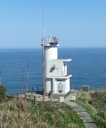
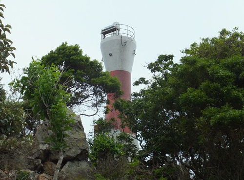
1964. Active; focal plane 56 m (184 ft); white light, 3 s on, 3 s off. 10 m (33 ft) round hourglass-shaped concrete tower, covered with tiles colored white with one red horizontal band. A photo is at right, Trabas has a photo, Yukihiro Matsumura has a 2019 photo, Lighthouse-Japan.com has a page with several photos, Lighthouse Visit has photos (fourth lighthouse on the page), Misty's Tour has additional photos, FOAL has photos (bottom of the page), a 2023 closeup is available, and Google has a satellite view. Located at the tip of a very sharp promontory on the east side of the entrance to Tsuiyama. Accessible by a rugged hike of about two hours round trip; the Misty's Tour author writes, "I was tired from ups and downs very much." Site open, tower closed. ARLHS JPN-604; JCG-0985; Admiralty M7275; NGA 2440.

Sutega Hana Light, Toyooka, May 2015
Tourist development photo copyright Tajima Furusato Association

Information available on lost lighthouses:

Notable faux lighthouses:

Adjoining pages: East: Kyōto and Fukui | West: Shimane

Return to the Lighthouse Directory index | Ratings key

Posted February 28, 2007. Checked and revised November 25, 2023. Lighthouses: 40. Site copyright 2023 Russ Rowlett and the University of North Carolina at Chapel Hill.