Lighthouses of Malaysia: West Malayasia Northeast Coast

The nation of Malaysia is in two parts: Peninsular Malaysia (also called West Malaysia or Malaya) on the southern end of the Malay Peninsula and Malaysian Borneo (East Malaysia) on the island of Borneo roughly 700 km (450 mi) to the east. West Malaysia is the former Federation of Malaya, a union of 11 states placed under British protectorate in the late 1800s. The Federation of Malaya became independent in 1957 and in 1963 the federation became Malaysia, a new country formed by uniting Malaya, Singapore, Sarawak, and Sabah (North Borneo). Singapore, a predominantly Chinese city just off the tip of the Malay Peninsula, left the union in 1965 and has been independent since.

West Malaysia faces one of the world's most important waterways, often called simply The Straits. The Strait of Malacca opens westward to the Indian Ocean and separates Malaya from the Indonesian island of Sumatra. At its southeastern end, the Strait of Malacca joins the Singapore Strait, which connects to the South China Sea and Pacific Ocean.

Malaysia is a federal constitutional monarchy consisting of thirteen states and three federal territories. This page describes lighthouses of the northeast coast of West Malaysia, facing the South China Sea in the states of Kelantan and Terengganu. Because international shipping lanes are far offshore in the South China Sea no major lighthouses were built on Malaya's east coast during the British Colonial period; with few exceptions the lights on this page are of relatively modern origin.

The Malay term for a lighthouse is rumah api ("house of fire"); pulau is an island, terumbu is a reef, tanjung is a cape, bukit is a hill, sungai is a river, kuala is the mouth of a river, teluk is a bay, selat is a strait, and pelabuhan is a harbor.

Aids to navigation in Malaysia are the responsibility of the Marine Department (Jabatan Laut).

ARLHS numbers are from the ARLHS World List of Lights. Admiralty numbers are from volume F of the Admiralty List of Lights & Fog Signals. U.S. NGA List numbers are from Publication 112.

General Sources
Lighthouses of Malaysia
Photos posted by Greenfinder.asia, a navigational aids and maritime services company.
Online List of Lights - Malaysia - South China Sea
Photos by various photographers posted by Alexander Trabas.
Lighthouses in Malaysia
Photos by various photographers available from Wikimedia.
Malaysian Lighthouses
Historic postcard views posted by Michel Forand.
Malaysia List of Lights 2020
Microsoft Excel spreadsheet with data for all the officiaal lights.
Leuchttürme Asiens, Australiens, und Ozeaniens auf historischen Postkarten
Historic postcard views posted by Klaus Huelse.
GPSNauticalCharts
Navigational chart for Malaysia.
Navionics Charts
Navigational chart for Malaysia.
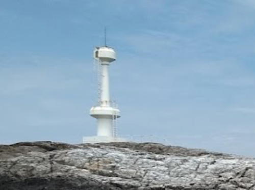
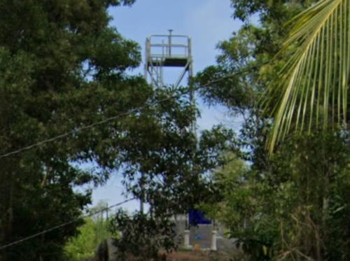
Tanjung Dungun Light, Dungun, March 2022
Google Maps photo by William Goh

Kelantan Lighthouses

A mostly rural state at the northern border of West Malayasia, Kelantan has only a short coastline on the South China Sea.

Tumpat District Lighthouses
Sungai Golok Transit
Date unknown. Active; focal plane 10 m (33 ft); white flash every 5 s. 10 m (33 ft) round white concrete tower on a square platform supported by piles. A distant view is available and Google has a satellite view. This light is listed by NGA as "Kelantan." The Golok River is the border between Malaysia and Thailand. This light is located in the mouth of the river on the Malaysian side of the channel. The Admiralty lists the light under Thailand. Accessible only by boat. Site open, tower closed. Admiralty F2895.5; NGA 20877.
* Tumpat
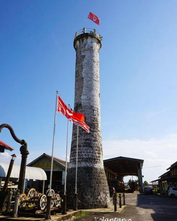
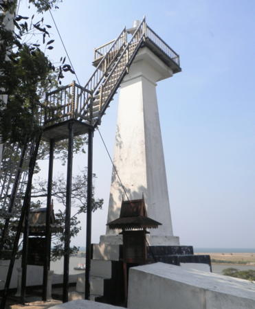
Date unknown. Inactive, probably since World War II. 21 m (70 ft) round brick tower with gallery; lantern removed. Lè Fēi Líng's photo at right shows the tower flying the red flag of Kelantan, William Goh has a 2022 photo, Wikimedia has a photo, a 2011 photo is available, and Google has a street view and a satellite view. The history of this lighthouse is unclear. The Malaysian source says it was built by local authorities around 1900, but it was not listed then by international light lists. More likely it was built by local authorities between the two World Wars and was active for only a few years. During World War II occupying Japanese forces used it as a watchtower and signal tower. Located close to the Malayan Railway station at Tumpat, Malaya's northernmost port on the South China Sea. Site open, tower closed. Owner/site manager: Keretapi Tanah Melayu (Malayan Railways Ltd.). . ARLHS WMA-032.

Kota Bharu District Lighthouses
Pulau Pantai Kuda (Pulau Kuda) (2?)
2013. Active; focal plane 10 m (33 ft); two white flashes every 5 s. 8 m (26 ft) concrete post with gallery. Greenfinder has a photo and Google has a satellite view. The Marine Department contracted for this new light in September 2012; NGA's description of a wood skeletal tower is obsolete. Located on the west side of the mouth of the Kelantan River, which leads to the state capital, Kota Bharu. Site status unknown. Admiralty F2891; NGA 20930.
#Sabak (Sungai Kelantan Approach)
Date unknown. Inactive at least since 2022 and apparently removed.This was a 15 m (49 ft) white skeletal tower. No photo available and the light is not seen in Google's satellite view. It's possible the light was removed prior to 2022. Located offshore northwest of the Pantai Senok entrance. Accessible only by boat. Site open, tower closed. ex-Admiralty F2890; NGA 20932.

Tumpat Light, Tumpat, December 2020
Google Maps photo by Lè Fēi Líng
* Pantai Senok (Pengkalan Datu)
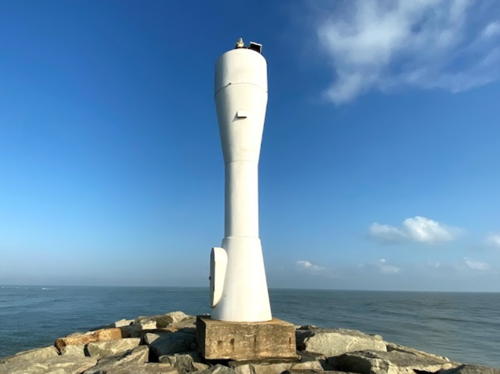
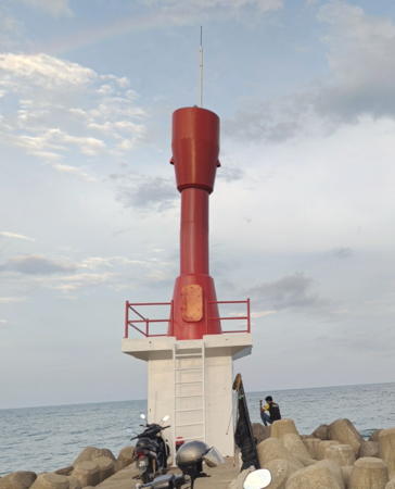
Date unknown (recent). Active; focal plane 14 m (46 ft); white flash every 5 s. 10 m (33 ft) white round hourglass-shaped fiberglass tower. Hata San has the 2019 closeup photo seen at right, Ulil IbnuZaki has a photo, another photo is available, and Google has a satellite view. This light was built to guide ships to a new harbor facility on the coast of Kelantan state, near the Thai border. Located on the east breakwater at Pantai Senok, about 15 km (9 mi) northeast of Kota Baharu, the capital of Kelantan state. . ARLHS WMA-021; Admiralty F2889; NGA 20934.

Bachok District Lighthouses
* #Bachok (Menchat)
Date unknown. Removed around 2020 but still listed with focal plane 12 m (39 ft); white flash every 5 s. 10 m (33 ft) square skeletal tower carrying a diamond shaped slatted daymark. Kar Chon Soo has a 2018 distant street view and Google has a 2019 closeup street view, but a 2021 street view confirms the removal. The small tower is hard to see in Google's satellite view. Located at Irama Beach in Bachok. Site open. Admiralty F2888; NGA 20936.
[Tok Bali South Breakwater]
Date unknown (recent). Active; focal plane 14 m (46 ft); quick-flashing red light. 10 m (33 ft) round white column carrying a box-like red daymark. Greenfinder has a photo and Google has a sea view and a satellite view. The north breakwater has a similar tower carrying triangular daymarks. Located on the south breakwater at the Tok Bali harbor in Semerak. Site open, tower closed. Admiralty F2887; NGA 20937.5.
 

Pantai Senok Light, Kota Bharu, December 2020
Google Maps photo by Hata San
 

Terengganu Lighthouses

Terengganu is a state and heritary sultanate that occupies much of the northeastern coast of Malaya. Its capital Kuala Terengganu is also an important port with a population of more than 425,000.

Besut District Lighthouses
* Sungai Besut (Kuala Besut)
Date unknown. Active; focal plane 12 m (39 ft); white flash every 2 s. 8 m (26 ft) square skeletal tower carrying a diamond shaped slatted daymark. Google has a street view and the small tower is centered in Google's satellite view. Located in downtown Kuala Besut, a fishing port and ferry terminal at the northern edge of Terengganu. Site open, tower closed. Admiralty F2885.5; NGA 20948.
Seabelle Rock
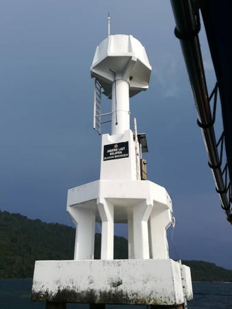
2002. Active; focal plane 9.5 m (32 ft); white flash every 4 s. 10 m (33 ft) white concrete post with gallery, mounted on an octagonal platform supported by eight concrete piles. Greenfinder has the closeup photo seen at right, Futfang Kucing has a 2022 photo, Mohamad Amirul Syafiq has a photo, William Cheng has a photo of tourists jumping from the lighthouse (this is common but not recommended), and Google has a distant satellite view. This interesting modern light is off the east coast of Terengganu state in the Perhentian Islands, an archipelago of coral islands and reefs. The region is included in a national park. Located about 20 km (13 mi) northeast of Kampong Kuala Besut, off the west coast of Pulau Perhentian Kecil. Accessible only by boat. Site open, tower closed. ARLHS WMA-022; Admiralty F2885.6; NGA 20942.
Pulau Perhentian Besar
Date unknown. Active; focal plane 44 m (144 ft); white flash every 7 s. 10 m (33 ft) concrete post with gallery. No photo available but Google has a satellite view. Located on the southwest tip of Perhentian Besar, the largest of the Perhentian Islands. Site status unknown. Admiralty F2885.7; NGA 20940.

Kuala Nerus District: Redang Islands Lighthouses
Pulau Cipu
Date unknown. Active; focal plane 31 m (102 ft); white flash every 5 s. 10 m (33 ft) concrete post rising from a square equipment shelter. Izham Satria has a 2020 photo, Greenfinder has a view from the sea, and Google has a satellite view. Located on a small island about 12 km (7.5 mi) off the coast and 35 km (22 mi) southeast of Kuala Besut. Accessible only by boat. Site open, tower closed. Admiralty F2885.17; NGA 20955.
Pulau Redang (Pulau Pinang, Redang Islands)
Date unknown. Active; focal plane 132 m (433 ft); white flash every 10 s. 10 m (33 ft) square white skeletal tower. 1-story keeper's house. No complete photo available; Huzaifah Jaafar has a 2022 photo showing a portion of the tower and Google has a satellite view. The light stands next to a popular observation tower. Pulau Pinang (NGA misspells it Penang) is the southernmost of the Redang Islands, an archipelago about 65 km (40 mi) north of Terengganu. The islands are a marine park popular with ecotourists. Located on the summit of the island. Accessible only by boat. Site status unknown. Site manager: Pulau Redang Marine Park. Admiralty F2885.1; NGA 20956.

Seabelle Rock Light, Perhentian Islands
Greenfinder photo used by permission
Pulau Leng
Date unknown. Active; focal plane 13 m (43 ft); two white flashes every 6 s. 13 m (43 ft) concrete post with a large gallery rising mounted on a round pier. No photo available but Google has a good satellite view. Located about 300 m (0.2 mi) north of Pulau Leng, an islet at the south end of the Redang Islands. Accessible only by boat. Site open, tower closed. Admiralty F2885.05; NGA 20957.
Pulau Batu Bara
2020. Active; focal plane 77 m (253 ft); white flash every 4 s. Approx. 7 m (23 ft) post with a square gallery carrying square white daymarks on three sides. Greenfinder has a closeup photo but the tower is not seen clearly in Google's satellite view. Located on a steep-sided island halfway between the Redang Islands and the mainland. Accessible only by boat. Site status unknown. Admiralty F2885.15; NGA 20958.
Batuan Rusa Utara
Date unknown. Active; focal plane 13 m (43 ft); two white flashes every 5 s. 13 m (43 ft) concrete tower with gallery on a platform supported by piles. No photo available but Google has a distant satellite view. Located about 8 km (5 mi) northeast of Tanjung Merang. Accessible only by boat. Site open, tower closed. Admiralty F2885.03; NGA 20959.

Setiu District Lighthouse
* Tanjung Merang (2)
Date unknown. Active; focal plane 21 m (62 ft); white flash every 4 s. Approx. 11 m (36 ft) square skeletal tower. Google has the 2021 street view seen at right and an indistinct satellite view. NGA lists a 6 m (20 ft) mast for this light. Located atop an earthen mount behind a small restaurant, on a low point of land about 32 km (20 mi) northwest of Kuala Terengganu. Site open, tower closed. Admiralty F2885; NGA 20960.
 

Tanjung Merang Light, Setiu, October 2021
Google Maps street view

Kuala Terengganu City Lighthouse
 
Batu Rakit
Date unknown. Active; focal plane 8 m (26 ft); two white flashes every 5 s. 8 m (26 ft) white concrete post rising from a square equipment shelter. Zaki Yone has a 2023 photo and Google has a satellite view. Located on a reef about 800 m (1/2 mi) off the beach at Batu Rakit, a resort community about 20 km (13 mi) north of Kuala Terengganu. Accessible only by boat. Site open, tower closed. Admiralty F2884; NGA 20964.
* Kuala Terengganu North Breakwater
Date unknown. Active; focal plane 18 m (59 ft); quick-flashing green light. Approx. 12 m (39 ft) post with a square gallery carrying square green daymarks on three sides. Ahmad Arshad has a closeup street view, there's a distant view from the south breakwater and a drone view of the two breakwater lights. Google has a satellite view. Locared at the end of the curving north outer breakwater of Terengganu. Accessible by walking the pier. Site open, tower closed. Admiralty F2880.9; NGA 20969.1.
* Bukit Puteri (Terengganu)
1909. Active; focal plane 35 m (115 ft); white flash every 3 s. Approx. 7 m (23 ft) brick post with a small gallery. A tall signal mast is beside the lighthouse. Aeshah Adlina Karim's photo is at right, a closeup and a 2008 view are available, Asri Rosdi has a photo, and Google has a street view and a satellite view. This historic light is now listed as a leading light for the harbor. Bukit Puteri is a hilltop 19th century fortress on the south side of the entrance to the Terengganu River in Kuala Terengganu, the capital of Terengganu state. Site open and a ladder gives access to the tower. ARLHS WMA-023; Admiralty F2880; NGA 20968.
#Kuala Terengganu
Date unknown. Removed. 8 m (26 ft) round cylindrical concrete block tower with gallery, painted white. Malik Yasin has a 2008 photo and a 2005 photo is available but the light has not been found in Google's satellite view. NGA 20970(?).
* Kuala Terengganu South Breakwater
Date unknown. Active; focal plane 18 m (59 ft); quick-flashing red light. Approx. 12 m (39 ft) post with a square gallery carrying square red daymarks on three sides. John Boon has a closeup photo, William Goh has a photo, and Google has a satellite view. Locared at the end of the curving north outer breakwater of Terengganu. Accessible by walking the pier. Site open, tower closed. Admiralty F2880.8; NGA 20969.

Bukit Puteri Light, Terengganu, September 2011
Wikimedia public domain photo by Aeshah Adlina Karim
 

Marang District Lighthouses
Chendering Head (Bukit Chendering)
Date unknown. Active; focal plane 76 m (249 ft); white flash every 5 s. 7.5 m (24 ft) square white skeletal tower. A 2018 closeup photo is available and Google has an indistinct satellite view. Located on heights above the Pandak Beach at Chendering (Cenderling), about 8 km (5 mi) south of Kuala Terengganu. Site status unknown. Admiralty F2878; NGA 20992.
Chendering North Breakwater (2)
Date unknown. Active; focal plane 8 m (26 ft); green flash every 3 s. 8 m (26 ft) post centered on a white 1-story concrete equipment shelter. A closeup 2022 photo is available, William Goh has another 2022 photo, and Google has a satellite view. NGA describes a skeletal tower for this light. Located at the end of the north (main) breakwater about 8 km (5 mi) south of Terengganu. Site status unknown. Admiralty F2878.5; NGA 20996.
* Chendering South Breakwater
Date unknown. Active; focal plane 8 m (26 ft) (?); red flash every 4 s. Approx. 12 m (39 ft) round hourglass-shaped fiberglass tower mounted on a square 1-story equipment shelter. The fiberglass tower is red and the equipment shelter is white. A Google street view is at right, Seng Chan has a photo, another photo and a closeup photo are available, and Google has a satellite view. The focal plane must be higher than the listed 8 m. Located at the end of the short south breakwater. Site open, and visitors can climb atop the equipment room. Not listed by the Admiralty. .
* Marang Breakwater
Date unknown. Active; focal plane 12 m (39 ft); red flash every 3 s. 9 m (30 ft) white concrete post with gallery; gallery painted red. Faridah Hanim has a 2023 photo and Google has a satellite view. Located on the south breakwater at the Marang River entrance, about 15 km (9 mi) south of Kuala Terengganu. Accessible by walking the pier. Site open, tower closed. Admiralty F2877; NGA 20998.
[Pulau Kapas]
Date unknown. Active; focal plane 29 m (95 ft); white flash every 10 s. Approx. 10 m (33 ft) steel post. Omar Solihin has a closeup photo, Haziq Hussain has a distant view, and Googl has a satellite view. Pulau Kapas is a resort island about 8 km (5 mi) off the coast of Marang. Located on a promontory on the southwest coast of the island. There is probably access by a hiking trail. Site status unknown. Admiralty F2876; NGA 21000.

Dungun District Lighthouses
Batu Kemudi
Date unknown (recent). Active; focal plane 16 m (52 ft); white flash every 6 s. 16 m (52 ft) tower, probably on a platform supported by piles. No description and no photo available, and the light is not shown in Google's satellite view. Located on a reef at the northern end of the Tenggol reef system. Admiralty F2869.8; NGA 21002.

South Breakwaterr Light, Chendering, September 2021
Google Maps street view by Izz Izz
Batu Tokong Dayak
Date unknown (recent). Active; focal plane 23 m (75 ft); white flash every 3 s. Approx. 14 m (46 ft) round two-stage white concrete tower. Siti Husna has the 2020 photo seen at right, Aidy Nahar Mohd Nasir has a 2018 photo, and Bing has a satellite view. Located about 1 km (0.6 mi) off the southern tip of the resort island of Pulau Tenggol and about 25 km (15 mi) due east of Dungun. Accessible only by boat. Site status unknown. Admiralty F2869.7; NGA 21003.
* Tanjung Dungun (Dungun Head, Tanjung Jara) (2)
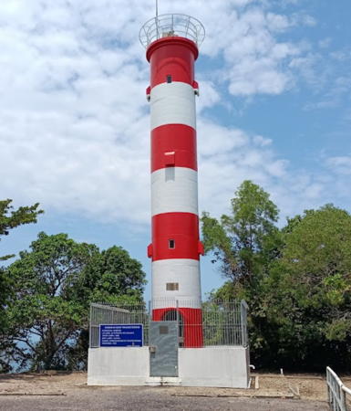
Date unknown (around 2010?). Active; focal plane 76 m (249 ft); white flash every 10 s. 18 m (59 ft) round cylindrical tower painted with red and white horizontal bands. William Goh's 2022 photo is at the top of this page, another photo is available, and Google has a 2014 street view and a satellite view. The earlier lighthouse, a square steel skeletal tower with lantern and gallery, was still in place in 2008. Located on a promontory sheltering the harbor of Dungun on the central east coast of Malaya. Accessible by a short walk on the access road. Admiralty F2870; NGA 21004.
[Tanjung Pelor (Kuala Paka)]
Date unknown. Active; focal plane 21 m (69 ft); white flash every 5 s. 8 m (26 ft) post centered on a square white concrete base. Google has a sea view and a distant satellite view. Located at the tip of a steep headland at Paka, about 15 km (9 mi) south of Dungun. Accessible only by boat. Admiralty F2869.5; NGA 21006.

Kemaman District Lighthouses
Kertih Approach
Date unknown. Active; focal plane 13 m (43 ft); white, red or green light, depending on direction, occulting once every 3 s. Approx. 10 m (33 ft) square skeletal tower. No photo available but Google has a satellite view. Kertih (Kerteh) is the base for Petronas oil and gas operations in the South China Sea. Located near the base of the Kertih pier. Site and tower closed. Admiralty F2869.29; NGA 21015.

Batu Tokong Dayak Light, Dungun, June 2020
Google Maps photo by Siti Husna
Kertih Marine Control Tower
Date unknown. Active; focal plane 35 m (115 ft); white or red light depending on direction, 1 s on, 1 s off. 33 m (108 ft) square skeletal tower painted with red and white horizontal bands. The 3-story port control building stands next to the tower. Cheewei Low has a photo, a second photo is available, and Google has a satellite view. Located on the waterfront of the port. Site and tower closed. Admiralty F2869.15; NGA 21016.
* Kertih Terminal Range Rear
Date unknown. Active; focal plane about 30 m (98 ft); continuous (?) red light. Approx. 27 m (89 ft) triangular skeletal tower painted with red and white horizontal bands and carrying a triangular daymark, point down. Google has a street view and a satellite view. Google also has a satellite view of the front light on a post about 15 m (49 ft) tall. Located in the Kertih Terminal beside the main Kemaman-Dungun highway. Site and tower closed but the tower is seen from the highway. Admiralty F2869.261.
Kemaman Inner Range Front
Date unknown. Active; focal plane 21 m (69 ft); quick-flashing green light. Approx. 18 m (59 ft) square skeletal tower carrying a triangular daymark painted white with a red vertical stripe. Google has a street view and a satellite view. Located on the waterfront of the Kemaman port at Chukai. Site and tower closed. Site manager: Konsortium Pelabuhan Kemaman. Admiralty F2860.7; NGA 21036.
Kemaman Inner Range Rear
Date unknown. Active; focal plane 27 m (89 ft); green light, 2 s on, 2 s off. Approx. 20 m (66 ft) square skeletal tower carrying a triangular daymark painted white with a red vertical stripe. Google has a satellite view and a very distant street view. Located 210 m (230 yd) north of the front light. Site and tower closed. Site manager: Konsortium Pelabuhan Kemaman. Admiralty F2860.71; NGA 21040.
Kemaman Entrance Range Front
Date unknown. Active; focal plane 21 m (69 ft); quick-flashing red light. Approx. 18 m (59 ft) square skeletal tower carrying a triangular daymark painted white with a red vertical stripe. Peerawat Lapcharoen has a distant photo and Google has a street view and a satellite view. Located on the waterfront of the Kemaman port at Chukai. Site and tower closed. Site manager: Konsortium Pelabuhan Kemaman. Admiralty F2859; NGA 21034.
Kemaman Entrance Range Rear
Date unknown. Active; focal plane 33 m (108 ft); red light, 2 s on, 2 s off. Approx. 25 m (82 ft) square skeletal tower carrying a triangular daymark painted white with a red vertical stripe. Google has a satellite view and a distant street view. Located 457 m (500 yd) northwest of the front light. Site and tower closed. Site manager: Konsortium Pelabuhan Kemaman. Admiralty F2859.1; NGA 21034.1.
* Sungai Kemaman (Bukit Pejajat)
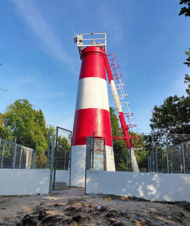
Date unknown. Active; focal plane 105 m (344 ft); white flash every 12 s. Approx. 12 m (39 ft) masonry tower painted with red and white horizontal bands. A photo is at right, a closeup photo is available, and Google has a satellite view. The tower is all white in Cik Zoah Ismail's 2010 photo. Kemaman is a major port supporting steel plants and the offshore oil and gas installations in the South China Sea. Located on a headland on the north side of the entrance to Kemaman, in southernmost Terengganu. Accessible by road and a steep walkway. Site open and an external tower provides access to the top of the tower. Admiralty F2862; NGA 21032.

Bukit Pejajit Light, Kemaman, March 2020
Google Maps photo by Razani

Information available on lost lighthouses:

Notable faux lighthouses:

Adjoining pages: North: Southern Thailand: East Coast | East: Natuna Sea Islands | South: Southeast West Malaysia

Return to the Lighthouse Directory index | Ratings key

Posted March 12, 2006. Checked and revised April 27, 2024. Lighthouses: 36. Site copyright 2024 Russ Rowlett and the University of North Carolina at Chapel Hill.