Lighthouses of Indonesia: Eastern Kalimantan (Borneo)

The Republic of Indonesia has been independent since 1945 after having been the Dutch East Indies for more than 350 years. It is a huge country, stretching along both sides of the Equator for more than 46 degrees of longitude (roughly 5100 km or 3200 miles). Comprised of some 17,000 islands (more than 6000 inhabited islands), it has hundreds of major aids to navigation.

Borneo, known as Kalimantan in Indonesia, is the world's third largest island. 73% of the island is Indonesian; the remaining portion includes the Malaysian states of Sarawak and Sabah and the independent sultanate of Brunei. Indonesian Kalimantan is separated from Sulawesi (Celebes) to the east by the Makassar Strait, from Java to the south by the Java Sea, and from Sumatra to the southwest by the Karimata Strait and Natuna Sea.

Indonesia is divided into 38 provinces (provinsi) and the provinces are subdivided into county units called regencies (kabupaten). This page describes lighthouses of eastern Kalimantan in Kutai Timur (East Kutai) Regency and Bontang City in East Kalimantan Province. Lighthouses of Berau Regency in the north of the province are included on the Northeastern Kalimantan page and lighthouses in the south of the province around Balikpapan are on the Southeastern Kalimantan page. The coast covered by this page faces Sulawesi (Celebes) across the broad Makassar Strait, a passage 130 to 370 km (80 to 250 mi) wide.

More than 700 languages are spoken in Indonesia. The official national language, Indonesian (Bahasa Indonesia), was standardized from a form of Malay that served as a lingua franca across the archipelago. In Indonesian a lighthouse is a mercusuar or a menara suar. Tanjung is a cape, ujung is a headland or point of land, bukit is a hill, sungai is a river, kuala or muara is an estuary or river mouth, pulau is an island, karang is a reef, batu is a rock, laut is a sea, selat is a strait, teluk is a bay, pelabuhan is a harbor, and labuhan is a port.

Aids to navigation in Indonesia are operated and maintained by the Directorate of Marine Navigation within the Directorate General of Sea Transportation

ARLHS numbers are from the ARLHS World List of Lights. Admiralty numbers are from volumes F and Q of the Admiralty List of Lights & Fog Signals. U.S. NGA List numbers are from Publication 112.

General Sources
Online List of Lights - Indonesia - Kalimantan - Celebes Sea
Photos by various photographers posted by Alexander Trabas.
Indonesian Lighthouses
Historic postcard views from the collection of Michel Forand.
World of Lighthouses - Indonesia
Photos by various photographers available from Lightphotos.net.
GPSNauticalCharts
Navigational chart information for eastern Kalimantan.
Kalimantan Timur Map
A useful map of eastern Kalimantan.
Navionics Charts
Navigation chart for eastern Kalimantan.
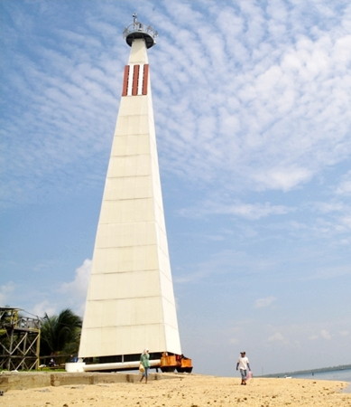
Pulau Beras Basah Light
Pulau Beras Basah Light, Makassar Strait, September 2012
photo copyright kedaihijau; permission requested
Kutai Timur (East Kutai) Regency Lighthouses
Tanjung Mangkalihat
Date unknown (station established 1910). Active; focal plane 42 m (138 ft); white flash every 5 s. 33 m (108 ft) square pyramidal iron skeletal tower, painted white. No photo available but Google has a satellite view of the station. This may be the original lighthouse. The lighthouse stands on the easternmost point of Borneo and marks the northern entrance to the Makassar Strait from the Celebes Sea. Site status unknown. ARLHS IDO-043; Admiralty F2024.5; NGA 24788.
Pulau Birahbirahan
Date unknown. Active; focal plane 14 m (46 ft); two white flashes every 10 s. 14 m (46 ft) tower mounted on a square platform. Lighthouse painted black with one red horizontal band. No photo available; Bing has a satellite view that probably shows the lighthouse. Located on a reef off the east end of an island about 100 km (60 mi) west southwest of Tanjung Mangkalihat. Accessible only by boat. Site open, tower closed. Admiralty F2024.6; NGA 24790.
Tanjung Batu
Date unknown. Active; focal plane 13 m (43 ft); green flash every 5 s. 13 m (43 ft) green skeletal tower on a platform supported by piles. No photo available but Google has a distant satellite view. Located on a shoal off Tanjung Batu, a headland on the east side of the Sangkulirang estuary at the head of Sangkulirang Bay. Accessible only by boat. Site open, tower closed. Admiralty F2024.71.
Pulau Singkuang
Date unknown. Active; focal plane about 12 m (39 ft); red light, pattern unknown. Approx. 12 m (39 ft) red barbell-shaped tower on a platform supported by piles. Google has a distant street view and Bing has an indistinct satellite view. Located in upper Sangkulirang Bay off the north end of the town of Benoa Baroe. Accessible only by boat. Site open, tower closed. Admiralty F2024.725.
* Pelabuhan Maloy
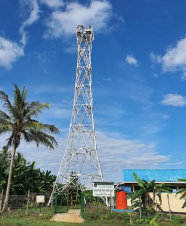
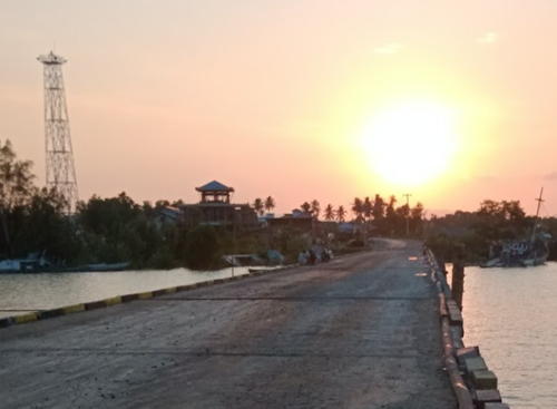
2019. Active; focal plane 32 m (105 ft); two white flashes every 10 s. 30 m (98 ft) square white skeletal tower. A distant view is at right, Ilham Fathul has a 2022 view from the river, and Google has an indistinct satellite view and a distant 2023 street view. Located near the foot of the pier at Maloy, a small port for the town of Benoa Baroe on the west side of the Sangkulirang estuary at the head of Sangkulirang Bay. Site open, tower closed. Admiralty F2024.7145.

Pelabuhan Maloy Light, Kutai Timur, November 2019
Google Maps photo by Ozi I
Pulau Senupa
Date unknown. Active; focal plane about 14 m (46 ft); red flash every 5 s. Approx. 14 m (46 ft) square red skeletal tower on a platform supported by piles. No photo available but Bing has an indistinct satellite view. Located off the northern tip of Pulau Senupa, an island in Sangkulirang Bay. Accessible only by boat. Site open, tower closed. Admiralty F2024.72.
Teluk Sangkulirang
Date unknown. Active; focal plane 14 m (46 ft); red flash every 5 s. 14 m (46 ft) square red skeletal tower on a platform supported by piles. No photo available and the light is not shown in Bing's satellite view. Located on the west side of the entrance to Sangkulirang Bay, an inlet on the south side of the Mangkalihat Peninsula. Accessible only by boat. Site open, tower closed. Admiralty F2024.7; NGA 24792.
Pulau Miang Besar
Date unknown. Active; focal plane 51 m (167 ft); white flash every 6 s. Approx. 25 m (82 ft) square skeletal tower with gallery, painted white. Four coast guard buildings. A photo is at right, Shodiq Muhammad has a 2021 photo, and Bing has a good satellite view. Located on an island off the entrance to the harbor of Sangkulirang Bay. Accessible only by boat. Site status unknown. ARLHS IDO-223; Admiralty F2024.65; NGA 24792.5.
Pelabuhan Miang Besar
Date unknown. Active; focal plane about 12 m (39 ft); green light, pattern unknown. Approx. 12 m (39 ft) square white skeletal tower on a platform supported by piles. Siti Rohimah has a 2023 view from shore and Google has a distant satellite view. Located ona shaol on the north side of the entrance to the harbor, on the north coast of Pulau Miang Besar. Accessible only by boat. Site open, tower closed. Admiralty F2024.68.
Karang Tanjung Bungalun
Date unknown. Active; focal plane 13 m (43 ft); two white flashes every 6 s. 13 m (43 ft) tower painted black with one red horizontal band. No photo available and the light is not seen in Bing's satellite view. Located on a shoal about 20 km (13 mi) south of the mouth of Sangkulirang Bay and 15 km (9 mi) off Tanjung Bungalun. Accessible only by boat. Site open, tower closed. Admiralty F2024.73; NGA 24793.
Sangatta (Batuta)
Date unknown. Active; focal plane 131 m (430 ft); white light, 1.5 s on. 3.5 s off. NGA describes a "white structure." This light is almost certainly on a communications tower seen in Bing's satellite view. No photo available. Sangatta is an important coal mining area. Located on heights above the port. Site status unknown. Admiralty F2024.75; NGA 24794.
 

Pulau Miang Besar Light, Kutai Timur, December 2019
Google Maps photo by Fadli Fd
Sangatta (Sengata) Reef
Date unknown. Active; focal plane 25 m (82 ft); two white flashes every 8 s. 25 m (82 ft) square skeletal tower on a platform supported by piles. No photo available but Google has a fuzzy satellite view. Located on a reef about 20 km (13 mi) southeast of the Sangatta wharf. Accessible only by boat. Site open, tower closed. Admiralty F2024.805; NGA 24796.
 

Bontang City: Pelabuhan Loktuan Lighthouses
Bontang is an industrial city of about 190,000 residents. Its busy ports export coal, natural gas, and fertilizer. The approaches to the various port facilities pass through a maze of marshy islands, requiring a large number of range lights.

Karang Kiampan
Date unknown. Active; focal plane 10 m (33 ft); green flash every 2 s. 10 m (33 ft) square green pyramidal metal tower with a daymark colored green. No photo available but Google has a satellite view. Located at the west point of a reef on the north side of the entrance to the northern harbor of the city. Accessible only by boat. Site status unknown. Admiralty F2025.7; NGA 24797.8.
Karang Kiampan South
Date unknown. Active; focal plane 10 m (33 ft); red flash every 3 s. 10 m (33 ft) square red pyramidal metal tower with a daymark colored red. No photo available but Google has a satellite view. Located at the west point of a reef on the south side of the entrance to the northern harbor of the city. Accessible only by boat. Site status unknown. Admiralty F2025.8; NGA 24798.
Pelabuhan Loktuan Segaja Range Front (C1)
Date unknown. Active; focal plane 12 m (39 ft); quick-flashing white light. 12 m (39 ft) square pyramidal metal tower with a daymark colored with black and white horizontal bands. No photo available but Google a satellite view. This is the first range guiding ships leaving the harbor. Located on a platform in a marsh about 5 km (3 mi) northeast of the harbor. Site status unknown. Admiralty F2025.6; NGA 24797.4.
Pelabuhan Loktuan Segaja Range Rear (C2)
Date unknown. Active; focal plane 12 m (39 ft); white light, 2 s on, 2 s off. 20 m (66 ft) square pyramidal metal tower with a daymark colored with black and white horizontal bands. No photo available but Google has a satellite view. Located on a platform in a marsh 320 m (0.2 mi) east southeast of the front light. Site status unknown. Admiralty F2025.61; NGA 24797.5.
Pelabuhan Loktuan Entrance Range Front (B1)
Date unknown. Active; focal plane 20 m (66 ft); quick-flashing white light. 12 m (39 ft) square pyramidal metal tower with a daymark colored with red and white horizontal bands. No photo available but Google has a satellite view. Located on a platform in a marsh about 5 km (3 mi) southeast of the harbor. Site status unknown. Admiralty F2025; NGA 24796.6.
Pelabuhan Loktuan Entrance Range Rear (B2)
Date unknown. Active; focal plane 20 m (66 ft); white light, 2 s on, 2 s off. 20 m (66 ft) square pyramidal metal tower with a daymark colored with red and white horizontal bands. No photo available but Google has a satellite view. Located on a platform in a marsh about 300 m (0.2 mi) west of the front light. Site status unknown. Admiralty F2025.1; NGA 24796.7.
Pelabuhan Loktuan Batutanbu Range Front (A1)
Date unknown. Active; focal plane 12 m (39 ft); quick-flashing white light. 12 m (39 ft) square pyramidal metal tower with a daymark colored with red and white horizontal bands. No photo available but Google has a satellite view. This is the second range guiding vessels departing the port. Located on a platform in a marsh about 8 km (5 mi) southeast of the harbor. Site status unknown. Admiralty F2025.4; NGA 24797.
Pelabuhan Loktuan Batutanbu Range Rear (A2)
Date unknown. Active; focal plane 20 m (66 ft); white light, 2 s on, 2 s off. 20 m (66 ft) square pyramidal metal tower with a daymark colored with red and white horizontal bands. A closeup photo is at right and Google has a satellite view. Located on a platform in a marsh 320 m (350 yd) south southeast of the front light. Site status unknown. Admiralty F2025.41; NGA 24797.1.
 

Baqtutanbu Range Rear Light, Loktuan, November 2018
Google Maps photo by Ansar Ansar

Bontang City: Pelabuhan Bontang Lighthouses
Bontang Outbound Range Rear (OC2)
Date unknown. Active; focal plane 23 m (75 ft); white light, 3 s on, 3 s off. 23 m (75 ft) square metal tower painted white. This light is the distance on the left in Nur Ishaq's distant view and in the center in a a drone view of the three lights and Google has a satellite view. Located in Bontang harbor about 600 m (3/8 mi) east of the Third Range Rear light. Accessible only by boat. Site open, tower closed. Admiralty F2029.1; NGA 24817.2.
Bontang Common Range Front (3A/OC1)
Date unknown. Active; focal plane 16 m (52 ft); quick-flashing white light. 16 m (52 ft) square metal tower painted white. Arief Riefsa's distant photo is at right, this light is in the center in Nur Ishaq's distant view and on the right in a drone view of the three lights, and Google has a satellite view. Located in Bontang harbor about 300 m (0.2 mi) southwest of the 02C rear light. Accessible only by boat. Site open, tower closed. Admiralty F2029; NGA 24817.
Bontang Third Range Rear (3B)
Date unknown. Active; focal plane 23 m (75 ft); quick-flashing white light. 23 m (75 ft) square metal tower painted white. Arief Riefsa's distant photo is at right, Nanang Harijono has a very distant view, this light is on the left in a drone view of the three lights and on the right in Nur Ishaq's distant view, and Google has a satellite view. Located in Bontang harbor about 1.2 km (3/4 mi) northeast of the waterfront. Accessible only by boat. Site open, tower closed. Admiralty F2028.9; NGA 24817.4.
Bontang Fourth Range Front (1D)
Date unknown. Active; focal plane 23 m (75 ft); quick-flashing white light. 23 m (75 ft) square metal tower painted with red and white horizontal bands and mounted on a square platform supported by piles. This light is in the foreground in a foggy drone view of the harbor and Google has a satellite view. Located in the Bontang natural gas harbor. Accessible only by boat. Site open, tower closed. Admiralty F2029.4; NGA 24818.

Bontang Range Lights 3A (left) and 3B
photo by Arief Riefsa
Bontang Fourth Range Rear (0D)
Date unknown. Active; focal plane 30 m (98 ft); quick-flashing white light. 30 m (98 ft) square metal tower painted with red and white horizontal bands and mounted on a square platform supported by piles. This light is in the center in a foggy drone view of the harbor and Google has a satellite view. Located 600 m (3/8 mi) west of the front light. Accessible only by boat. Site open, tower closed. Admiralty F2029.41; NGA 24818.1.
Bontang Fifth Range Front (1G)
Date unknown. Active; focal plane 16 m (52 ft); quick-flashing white light. 16 m (52 ft) square metal tower painted white and mounted on a square platform supported by piles. This light is to the right of the front light near the left edge in a distant foggy drone view of the harbor and Google has a satellite view. Located south of the Bontang natural gas harbor. Accessible only by boat. Site open, tower closed. Admiralty F2031; NGA 24819.
Bontang Fifth Range Rear (0G)
Date unknown. Active; focal plane 16 m (52 ft); white light, 3 s on, 3 s off. 16 m (52 ft) square metal tower painted white and mounted on a square platform supported by piles. This light is on the right in the center of in a distant foggy drone view of the harbor and Google has a satellite view. Located 300 m (0.2 mi) southwest of the front light. Accessible only by boat. Site open, tower closed. Admiralty F2031.1; NGA 24819.1.
Bontang Second Range Rear (2B)
Date unknown. Active; focal plane 23 m (75 ft); quick-flashing white light. 23 m (75 ft) square metal tower painted white. No photo available but Google has a satellite view. Located about 5 km (3 mi) southeast of the natural gas harbor. Accessible only by boat. Site open, tower closed. Admiralty F2028.31; NGA 24816.
Bontang Second Range Front (2A)
Date unknown. Active; focal plane 16 m (52 ft); quick-flashing white light. 16 m (52 ft) square metal tower painted white. No photo available but Google has a satellite view. Located about 650 m (3/8 mi) southeast of the front light. Accessible only by boat. Site open, tower closed. Admiralty F2028.3; NGA 24812.
* Pulau Beras Basah
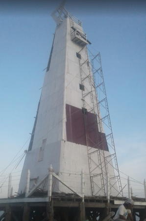
Date unknown. Active; focal plane 36 m (118 ft); five white flashes, in a 3+2 pattern, every 20.5 s. 35 m (115 ft) square pyramidal metal tower with gallery, enclosed with metal plates. A photo is at the top of this page, Muhammad Ayarni has a 2021 photo, Wikimedia has a more distant view, a 2014 photo is available, Andy Putra has a closeup photo, and Google has a satellite view. As of 2009 the tower was in poor condition, and some of the plates had fallen off. Apparently the lighthouse was repaired and restored in 2011. Beras Basah is a popular resort island almost precisely on the Equator, about 8 km (5 mi) southeast of the port of Bontang. Located on the beach. Site open, tower closed. Admiralty F2027; NGA 24808.
Bontang Entrance Range Front (1A)
Date unknown. Active; focal plane 16 m (52 ft); quick-flashing white light. 16 m (52 ft) square metal tower painted white. No photo available but Google has a satellite view. Located about 2 km (1.2 mi) southwest of Pulau Beras Basah. Accessible only by boat. Site open, tower closed. Admiralty F2028; NGA 24800.
Bontang Entrance Range Rear (1B)
Date unknown. Active; focal plane 23 m (75 ft); quick-flashing white light. 23 m (75 ft) square metal tower painted white. No photo available but Google has a satellite view. Located about 600 m (3/8 mi) northwest of the front light. Accessible only by boat. Site open, tower closed. Admiralty F2028.1; NGA 24804.
Tanjung Meranggas Range Rear
Date unknown. Active; focal plane 18 m (59 ft); white light, 2 s on, 2 s off. 18 m (59 ft) square metal tower painted white. No photo available but Google has a satellite view. The front light is on a short skeletal tower. Google also has a satellite view of the front light, on a similar tower 7 m (23 ft) tall). Located on a marshy point across from the Bontang Coal terminal. Accessible only by boat. Site open, tower closed. Admiralty F2028.21; NGA 24810.1.
 

Information available on lost lighthouses:

Notable faux lighthouses:

Adjoining pages: North: Northeastern Kalimantan | Northeast: Northern Sulawesi | East: Western Sulawesi | South: Southeastern Kalimantan

Return to the Lighthouse Directory index | Ratings key

Posted December 9, 2008. Checked and revised May 8, 2024. Lighthouses: 33. Site copyright 2024 Russ Rowlett and the University of North Carolina at Chapel Hill.