Lighthouses of Indonesia: Eastern Sulawesi (Celebes)

The Republic of Indonesia has been independent since 1945 after having been the Dutch East Indies for more than 350 years. It is a huge country, stretching along both sides of the Equator for more than 46 degrees of longitude (roughly 5100 km or 3200 miles). Comprised of some 17,000 islands (more than 6000 inhabited islands), it has hundreds of major aids to navigation.

Sulawesi (Celebes) is a major island in the northern part of the country. Shaped like an artistically drawn letter K, Sulawesi consists mostly of four narrow peninsulas. The Makassar Strait separates Sulawesi from Kalimantan (Borneo) to the west. The Celebes Sea is north of the island, the Molucca Sea is on the northeast, the Banda Sea is to the southeast, and the Flores Sea is on the south.

Indonesia is divided into 38 provinces and the provinces are subdivided into regencies (kabupaten). This page includes lighthouses on the east side of the island in the southern half of Sulawesi Tengah (Central Sulawesi) Province, including the coasts of the Gulf of Tolo, the arm of the Banda Sea separating the Eastern Peninsula of Sulawesi from the Southeast Peninsula. Lighthouses on the east side of the island in the northern half of the province are described on the Northeast Sulawesi page. The province also has a coast on the west side of the island; lighthouses on that coast are described on the Western Sulawesi page.

More than 700 languages are spoken in Indonesia. The official national language, Indonesian (Bahasa Indonesia), was standardized from a form of Malay that served as a lingua franca across the archipelago. In Indonesian a lighthouse is a mercusuar or a menara suar. Tanjung is a cape, ujung is a headland or point of land, bukit is a hill, sungai is a river, kuala or muara is an estuary or river mouth, pulau is an island, karang is a reef, batu is a rock, laut is a sea, selat is a strait, teluk is a bay, pelabuhan is a harbor, and labuhan is a port.

Aids to navigation in Indonesia are operated and maintained by the Directorate of Marine Navigation within the Directorate General of Sea Transportation.

ARLHS numbers are from the ARLHS World List of Lights. Admiralty numbers are from volumes F and Q of the Admiralty List of Lights & Fog Signals. U.S. NGA List numbers are from Publication 112.

General Sources
Online List of Lights - Indonesia - Sulawesi
Photos by various photographers posted by Alexander Trabas.
Indonesian Lighthouses
Historic postcard views from the collection of Michel Forand.
World of Lighthouses - Indonesia
Photos by various photographers available from Lightphotos.net.
Sulawesi Map
A useful map from orangesmile.com.
Navionics Charts
Navigation chart for Sulawesi.

Tanjung Tumbuk Light, Luwuk, August 2019
Google Maps photo by Ucik Ucik
Banggai Regency: South Coast Lighthouses
Luwuk is the capital of Banggai Regency and a town of about 35,000 residents, located on the south side of the eastern peninsula of Sulawesi across the Peleng Strait from Pulau Peleng.

Luwuk Pertamina (Oil Depot)
Date unknown. Active; focal plane 11 m (36 ft); four white flashes every 10 s. 10 m (33 ft) square pyramidal white tower with gallery. Qmas Asi has a photo (tower in upper right corner) and a second photo and Google has a satellite view. Located at the oil terminal on the east side of Luwuk. Site and tower closed. Admiralty Q1566.3; NGA 25256.
Luwuk Entrance
Date unknown. Active (?); charted with focal plane 16 m (52 ft); white flash every 5 s. Approx. 14 m (46 ft) square white skeletal tower mounted on a platform supported by piles. No photo available but Google has a satellite view and a distant street view across the harbor. Located just offshore about 450 m (1/4 mi) northeast of the Luwuk North Light (next entry). Site and tower closed. Charted by Navionics and C-Map but not listed by the Admiralty.
Luwuk North
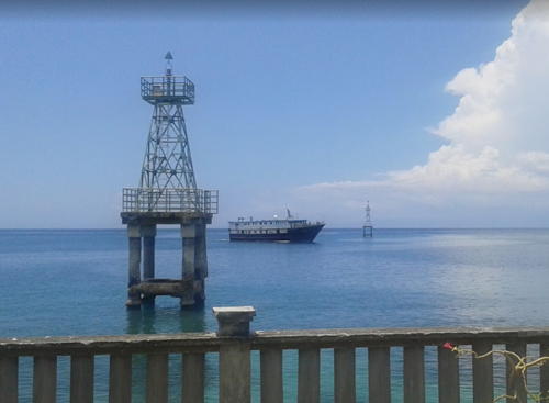
Date unknown. Active; focal plane 18 m (59 ft); green flash every 5 s. 18 m (59 ft) square skeletal tower mounted on a platform supported by piles. This light is in the foreground of Shen Chen's photo at right and Google has a satellite view and a distant street view across the harbor. NGA lists this tower with a white light but Navionics and C-Map chart it as a green light. Located just offshore on the north (starboard) side of the entrance to Lalong Bay, the city's harbor. Accessible only by boat but there are good views from shore. Site open, tower closed. Admiralty Q1566; NGA 25252.
Luwuk South (Tanjung Tumbuk) (2?)
Date unknown. Active; focal plane 10 m (33 ft); red flash every 3 s. 10 m (33 ft) square red skeletal tower mounted on a platform supported by piles. This light is in the background of Shen Chen's photo at right and Google has a street view and a satellite view. NGA lists this tower with a white light but Navionics and C-Map chart it as a red light. Located just offshore on the south (port) side of the entrance to the harbor. Accessible only by boat but there are good views from shore. Site open, tower closed. Admiralty Q1566.4; NGA 25257.
Tanjung Tumbuk
Date unknown. Active; focal plane about 20 m (66 ft); red flash every 2 s. 20 m (66 ft) square red skeletal tower on a 1-story equipment building mounted on a platform supported by piles. Equipment building and piles also painted red. A closeup photo is at the top of this page, Fredy Lukas has a view from shore and Google has a street view and a satellite view. Located off Tanjung Tumbuk on the south (port) side of the entrance to the harbor, about 250 m (0.15 mi) west of the Luwuk South Light. Accessible only by boat. Site open, tower closed. Admiralty Q1566.5.

Luwuk North (left) and South Lights, Luwuk, March 2017
Google Maps photo by Shen Chen
Mondono (Mendono)
Date unknown. Active; focal plane 13 m (43 ft); white flash every 4 s. 13 m (43 ft) square white skeletal tower mounted on a platform supported by piles. No photo available but Google has a fuzzy satellite view. Located just off a promontory about 25 km (15 mi) southwest of Luwuk. Accessible only by boat but there must be good views from shore. Site open, tower closed. Admiralty Q1565.5; NGA 25249.
* Pelabuhan Tangkiang
Date unknown. Active; focal plane 15 m (49 ft); white flash every 3 s. Approx. 13 m (43 ft) square white skeletal tower mounted on a square white 1-story equipment building. Agung Dwijo Susilo has a closeup photo, the light is at the far right in Radita Kurniawan's photo, Eric Pajow has a similar photo, and Google has an indistinct satellite view. Located on the quay at Tangkiang, a small port about 40 km (25 mi) southwest of Luwuk. Site open, tower closed. Admiralty Q1565.4.
Donggi LNG Port Range Front
2009. Active; focal plane 29 m (95 ft); white light, 1 s on, 1 s off. 26 m (85 ft) white skeletal tower. No photo available but Google has an indistinct satellite view. Located at an industrial port near Uso, about 65 km (40 mi) southwest of Luwuk. Site and tower closed. Admiralty Q1565.2.
Donggi LNG Port Range Rear
2009. Active; focal plane 37 m (1221 ft); white light, 2 s on, 2 s off. 26 m (85 ft) white skeletal tower. No photo available but Google has an indistinct satellite view. Located at an industrial port near Uso, about 400 m (1/4 mi) northeast of the front light. Site and tower closed. Admiralty Q1565.21.

Kepulauan Banggai (Banggai Islands) Regency Lighthouses
The Banggai Islands are an archipelago off the south side of Sulawesi's East Peninsula; the oddly-shaped Pulau Peleng is by far the largest of the islands. The Peleng Strait (Selat Peleng) separates the islands from the Peninsula.

Tanjung Kembani
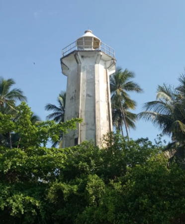
Date unknown. Active; focal plane 22 m (72 ft); white flash every 10 s. 20 m (66 ft) octagonal concrete tower with lantern and gallery. Entire lighthouse is white. Zainudin Malingong's 2019 photo is at right, Ihsan Tunggul has a 2021 closeup, and Google has a satellite view. Located on the southern tip of Peleng. Site status unknown. Admiralty Q1565; NGA 25274.3.
Karang Thames (Thames Reef)
Date unknown. Active; focal plane 14 m (46 ft); red light, 1.5 s on, 2.5 s off. 14 m (46 ft) tower (probably skeletal) mounted on a platform supported by piles. No photo available and Google's satellite view has only a blurry spot for the reef. Located about 15 km (9 mi) southwest of Pulau Peland in the southern entrance to the Pelang Strait. Accessible only by boat. Site appears open, tower closed. Admiralty Q1564.8; NGA 25274.2.
Tanjung Tobo
Date unknown. Active; focal plane 17 m (56 ft); white flash every 5 s. Approx. 14 m (46 ft) square skeletal tower. Google has a 2021 street view and a distant satellite view. Located beside a road on a prominent point of land on the north coast of Pulau Peleng. Site appears open, tower closed. Admiralty Q1566.6; NGA 25275.
Tanjung Montok (Montop)
Date unknown. Active; focal plane 9 m (30 ft); green flash every 5 s. 9 m (30 ft) tower (form unknown) on a platform supported by piles. No photo available but Bing has a blurry satellite view. Located at the east end of reefs on the west side of the entrance to Bakalan Bay, a large inlet on the north side of Pulau Pelang. Accessible only by boat. Site open, tower clsoed. Admiralty Q1566.8; NGA 25275.6.

Tanjung Kembani Light, Pulau Peleng, May 2019
Google Maps photo by Zainudin Malingong
* Salakan
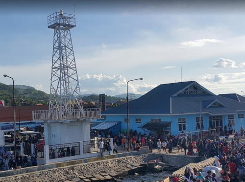
Date unknown. Active; focal plane 16 m (52 ft); white flash every 3 s. Approx. 14 m (46 ft) square white skeletal tower mounted atop a waterfront building. Eko Wahyudiantoro has a 2017 photo (also seen at right), Jodah Sukarno has a 2019 photo, Syauqi Akib has a 2018 closeup, and the tower is centered in Google's satellite view. Located at the ferry terminal in Salakan, a town on the southeastern shore of Bekalan Bay. Site open, tower closed. Admiralty Q1567.
Lamobuang
Date unknown. Active; focal plane 7 m (23 ft); green flash every 3 s. 7 m (23 ft) square skeletal tower mounted on a platform supported by piles. Google has a 2021 street view and a satellite view. Located off the east end of the Salakan waterfront. Accessible only by boat. Site open, tower closed. Admiralty Q1567.5; NGA 25275.7.
Bungin (Pulau Bangkalan Selatan)
Date unknown. Active; focal plane 17 m (56 ft); red flash every 3 s. 17 m (49 ft) square white skeletal tower mounted on a platform supported by piles. No photo available but Google has a satellite view. Located on a reef at the entrance to the harbor of Bungin, a village on the west side of Pulau Bangkalan Selatan opposite the Tanjung Montok light. Accessible only by boat. Site open, tower closed. Admiralty Q1566.75.
Tanjung Bankalan Utara (Bankalan North)
Date unknown. Active; focal plane 50 m (164 ft); white flash every 6 s. Approx. 20 m (66 ft) skeletal tower, painted white. No photo available but Google has a satellite view.This light marks the south side of the entrance to the Peleng Strait. Located in dense forest on the north end of Pulau Bangkalan Utara, the more northern of two islands in the opening of Bekalan Bay, a deep bay on the north side of Pulau Peleng. Site status unknown. Admiralty Q1566.7; NGA 25275.5.

Salakan Light, Salakan, December 2017
ex-Google Maps photo by Eko Wahyudiantoro

Pondipondi (Pulau Tambun)
Date unknown. Active; focal plane 84 m (276 ft); white flash every 4 s. Approx. 20 m (66 ft) square skeletal tower. No photo available but Google has an indistinct satellite view. Located on Pulau Tambun, a small island off the northeastern side of Pulau Peleng. Accessible only by boat. Site status unknown. Admiralty Q1567.6; NGA 25275.58.
Tanjung Sambiut
Date unknown. Active; focal plane 14 m (46 ft); white flash every 4 s. 14 m (46 ft) white tower mounted on a platform supported by piles. Google has a distant street view and a satellite view. Located in the surf a short distance north of Abason village on the southeast coast of Pulau Pelang. Site open, tower closed. Admiralty Q1567.7; NGA 25275.8.

Banggai Laut Regency Lighthouses
In 2012 the Banggai Islands southeast of Pulau Pelang were separated from the Banggai Islands Regency to form the Banggai Laut Regency. "Banggai Laut" means "Banggai Sea," or perhaps "Outer Banggai" is the better translation. Pulau Banggai itself is in this new regency. These islands separate the Molucca Sea to the north from the Banda Sea to the south, and they extend eastward almost to Taliabu, a larger island in North Maluku Province.
* Pulau Banggai (2)
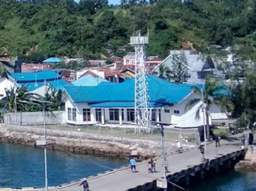
Date unknown. Active; focal plane about 20 m (66 ft); white flash every 5 s. Approx. 17 m (56 ft) square white skeletal tower. Rifai Pa'i's photo is at right, Suhirman Simal has a view from the sea, Sintia Dwi Rahmawati has a 2022 photo, Eko Wahyudiantoro has a street view and Google has an indistinct satellite view. NGA lists a very small tower with a continuous red light. Located on the quay at the town of Banggai, on the west coast of Pulau Banggai. Site open, tower closed. Admiralty Q1568; NGA 25276.
Pulau Bakakang (Babakang) Besar
Date unknown. Active; focal plane 12 m (38 ft); white flash every 3 s. 12 m (39 ft) white barbell-shaped fiberglass tower on a platform supported by piles. No closeup photo available but the light is barely visible beyond the islands in an aerial photo and Google has a distant satellite view. The light guides vessels approaching town of Banggai. Located at the south end of a reef about 5 km (3 mi) west of Banggai. Accessible only by boat. Site open, tower closed. Admiralty Q1568.4; NGA 25378.
Pulau Toulon Besar
Date unknown. Active; focal plane 14 m (46 ft); red flash every 5 s. 14 m (46 ft) red barbell-shaped fiberglass tower mounted on a platform supported by piles. No photo available but Bing has an indistinct satellite view. This light guides vessels in the Kahumbahgan Strait separating Pulau Peleng from Pulau Banggai. Located at the northern tip of Pulau Toulon Besar, a smaller island just off the west coast of Pulau Banggai. Site open, tower closed. Admiralty Q1567.8; NGA 25275.9.
Pulau Kenau (2?)
Date unknown. Active; focal plane 12 m (38 ft); white flash every 3 s. 12 m (39 ft) tower on a square platform supported by piles. No photo available and clouds block Bing's satellite view. Pulau Kenau is a smaller island off the south end of Pulau Banggai. Located just off the southern tip of Pulau Kenau. Accessible only by boat. Site open, tower closed. Admiralty Q1568.5; NGA 25379.

Pulau Banggai Light, Banggai, March 2018
Google Maps photo by Rifai Pa'i

Pulau Buangbuang (Buang Buang)
Date unknown. Active; focal plane 28 m (92 ft); white flash every 5 s. 25 m (82 ft) square skeletal tower, painted white. Several coast guard station buildings. A portion of a view from the sea is at right and Google has a satellite view of the station. Located on a small island at the southeastern tip of the Banggai group, marking a narrow passage between the Banggai reefs and those of the Sula group in North Maluku province. Accessible only by boat. Site status unknown. Admiralty Q1569; NGA 25380.
Karang Vesuvius
Date unknown. Active; focal plane 13 m (43 ft); two white flashes every 8 s. 13 m (43 ft) square white skeletal tower on a platform supported by piles. No photo available and Bing has only a fuzzy satellite view of the reef. Located on a reef at the extreme southwestern corner of the Outer Banggai Islands. Accessible only by boat. Site open, tower closed. Admiralty Q1564.77.

Morowali Utara (North Morowali) Regency Lighthouses
North Morowali Regency is on the central east coast of Sulawesi, southwest of the Banggai Regency. The regency surrounds Tomori Bay, a complex embayment at the base of Sulawesi's eastern peninsula. Kolonodale is the regency capital.

Ambang Luar
Date unknown. Active; focal plane 18 m (59 ft); white flash every 5 s. Described as a beacon with red and white horizontal bands. No photo available and Bing has only a very distant satellite view of the reef. This light marks the entrance to Tomori Bay through a gap in a long Mantaha barrier reef paralleling the coast of Sulawesi. Located about 16 km (10 mi) offshore. Accessible only by boat. Site open, tower closed. Admiralty Q1563; NGA 25264.

Pulau Buang Buang Light, Banggai, May 2019
Google Maps photo by Bambang Nuki Wiradibrata

Tomori Bay Approach
Date unknown. Active; focal plane 18 m (59 ft); white flash every 5 s. 18 m (59 ft) tower, upper half painted yellow and lower half black, on a platform supported by piles. No photo available and the light is not shown in Google's satellite view. This light marks a deep break in the Mantaha Reef. Located about 25 km (15 mi) east of the north side of the entrance to Teluk Tomori. Accessible only by boat. Site open, tower closed. Charted by C-Map but not listed by the Admiralty
Tanjung Bea
Date unknown. Active; focal plane 18 m (59 ft); white flash every 5 s. 15 m (49 ft) skeletal tower, painted white. No photo available but Bing has a satellite view. Located on a promontory near the base of Sulawesi's eastern peninsula, near Morowali. Site status unknown. Admiralty Q1563.5; NGA 25268.
Tanjung Matube
Date unknown. Active; focal plane 16 m (52 ft); green flash every 4 s. 16 m (52 ft) "beacon," probably a green skeletal or fiberglass tower. No photo available and the light not seen in Google's indistinct satellite view of the point. Oddly, NGA lists the light as "Tanjung Mposo." Located on the north side of the entrance to Tomori Bay. Site status unknown. Admiralty Q1564; NGA 25272.
Karang Dalam Oll
Date unknown. Active; focal plane 15 m (49 ft); white flash every 4 s. 15 m (49 ft) square white skeletal tower mounted on a platform supported by piles. No photo available but Google has a fuzzy satellite view. Located on a reef in the center of the entrance to the Tomori Bay. Accessible only by boat. Site open, tower closed. Admiralty Q1564.2; NGA 25273.
Pulau Tokodimba
Date unknown. Active; focal plane 27 m (89 ft); green flash every 3 s. 27 m (89 ft) skeletal tower on a platform supported by piles. No photo available but Google has an indistinct satellite view. Located at the edge of promontory on the west side of the approach to Kolondale. Accessible only by boat. Site open, tower closed. Admiralty Q1564.3.
Pulau Batutengah
Date unknown. Active; focal plane 27 m (89 ft); red flash every 3 s. 27 m (89 ft) skeletal tower on a platform supported by piles. No photo available but Bing has an indistinct satellite view. Located at the west edge of a small island on the east side of the approach to Kolondale. Accessible only by boat. Site open, tower closed. Admiralty Q1564.5.
Kolonodale
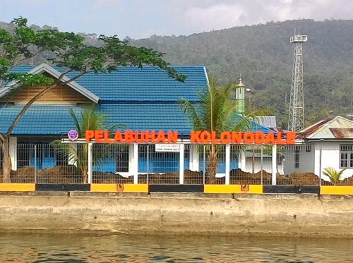
Date unknown. Active; focal plane 33 m (108 ft); two white flashes every 8 s. 30 m (98 ft) square skeletal tower, painted white. Sukri Ukhy's photo is at right, Steni Moai has a 2024 photo, the light tower is near the right edge of Rheza Khalid's 2021 photo, and Google has a satellite view. Located at the harbor of Kolonodale, the regency capital and a seaport on the west coast of Tomori Bay. Site open, tower closed. Admiralty Q1564.7; NGA 25274.
Teluk Tomori South
Date unknown. Active; focal plane 14 m (46 ft); red light, 1.5 s on, 2.5 s off. 14 m (46 ft) red barbell-shaped fiberglass tower mounted on a platform supported by piles. No photo available but Bing has a satellite view. This light guides away from shoals at the southern entrance to Tomori Bay. Located at the northern tip of Pulau Toulon Besar, a smaller island just off the west coast of Pulau Banggai. Site open, tower closed. Admiralty Q1563.2; NGA 25266.

Kolonodale Light, Kolonodale, October 2015
ex-Google Plus photo by Sukri Ukhi

Morowali Regency Lighthouses
The Morowali Regency includes the east side of the base of Sulawesi's Southeast Peninsula plus the Menui Islands, a ragged chain extending east southeast into the Banda Sea.

Karang Bungku
Date unknown. Active; focal plane 14 m (46 ft); white flash every 4 s. Approx. 14 m (46 ft) square white skeletal tower mounted on a platform supported by piles. Muhammad Ilham has a distant view, Miatama Yusri also has a distant view, and Google has a fuzzy satellite view. Located on a reef that provides some partial shelter to the port of Bungku, the regency capital. Accessible only by boat. Site open, tower closed. Admiralty Q1562.9.
Tanjung Losoni
Date unknown. Active; focal plane 50 m (164 ft); four white flashes every 10 s. Approx. 40 m (131 ft) white skeletal tower with lantern and gallery. Four 1-story coast guard station buildings. Hartati Monda has a 2021 closeup photo and Google has a satellite view of the station. This light stands on a promontory at Losoni on the central east coast of Sulawesi. Site status unknown. ARLHS IDO-311; Admiralty Q1562.93; NGA 25274.6.
Karang Samaringa
Date unknown. Active; focal plane 13 m (43 ft); red flash every 5 s. 13 m (43 ft) square skeletal mast with gallery painted red and mounted on a square platform supported by piles. No photo available but Google has a satellite view. Located on a reef northwest of Pulau Samaringa, a small island at the western end of the Menui Islands. Accessible only by boat. Site open, tower closed. Admiralty Q1559.95; NGA 25278.
Pulau Menui (Manui)
Date unknown. Active; focal plane 45 m (148 ft); white flash every 4 s. Approx. 40 m (131 ft) square white skeletal tower. No photo available but Google has a satellite view. This major lighthouse marks the eastern end of the Manui Islands. Located on heights above the southeastern point of Pulau Manui, a 12 km (7.5 mi) long high island about 80 km (50 mi) northeast of Kendari. Accessible only by boat. Site status unknown. Admiralty Q1559.8; NGA 25279.

Information available on lost lighthouses:

Notable faux lighthouses:

Adjoining pages: North: Northeastern Sulawesi | East: North Maluku | Southeast: Central Maluku | South: Southeast Sulawesi | West: Western Sulawesi

Return to the Lighthouse Directory index | Ratings key

Posted December 18, 2008. Checked and revised July 16, 2024. Lighthouses: 38. Site copyright 2024 Russ Rowlett and the University of North Carolina at Chapel Hill.