Lighthouses of Russia: Caspian Sea

Russia (Россия, Rossiya in Russian) is by far the world's largest country, spanning a little over 150° in longitude. It is organized as the Russian Federation (Rossiyskaya Federatsiya) with members known as federal subjects (sub'yekty federatsii). Russia is primarily a continental nation but it has important coastlines on the Baltic, Black, and Caspian Seas and very long coastlines on the Arctic Ocean and North Pacific Oceans. To guard these coasts it operates hundreds of lighthouses, many of them historic.

The Caspian Sea is the world's largest lake, with a length of about 1100 km (700 mi). It receives the waters of the Volga and Ural Rivers and many smaller streams, but it has no outlet to the ocean. Prior to the fall of the Soviet Union in 1991 Soviet republics bordered all of the Caspian Sea except the south coast, which is in Iran. Today the southwest coast is in Azerbaijan, the southeast coast is in Turkmenistan, and the northeast coast is in Kazakhstan. Russia borders the north and northwest coasts.

The Caspian Sea is at the southeastern corner of Russia's extensive network of inland waterways. The Volga River, Europe's longest river, forms the backbone of this system as it drains southward into the Caspian Sea. The lower portion of the Volga is connected to the Don River and the Black Sea by the Volga-Don Canal, providing a connection from the Caspian to the Mediterranean Sea.

During the Soviet era about two dozen major lighthouses were built on the Caspian Sea. Some are abandoned today but many others remain in use. Since aids to navigation on inland waterways such as the Caspian Sea are not listed on international light lists, we have very little information about them.

The Russian word for a lighthouse is mayak (маяк); ostrov is an island, rif is a reef, mys is a cape, bukhta is a bay, zaliv is a larger bay or gulf, proliv is a strait, reka is a river, and gavan' is a harbor. In Russian the Caspian Sea is Kaspiyskoye more.

Russia's aids to navigation on the Caspian Sea are presumably maintained by Rosmorrechflot, the Federal Agency for Maritime and River Transport.

ARLHS numbers are from the ARLHS World List of Lights. Lighthouses on the landlocked Caspian are not included in international light lists.

General Sources
World of Lighthouses - Caspian Sea Coast of Russia
Photos by various photographers available from Lightphotos.net.
Caspian Sea lighthouses in Russia
Photos by various photographers available from Wikimedia.
Lighthouses of the Caspian Sea
Information (in Russian) from the Russian Lighthouse Society.
Russische Leuchttürme auf historischen Postkarten
Historic postcard images posted by Klaus Huelse.
Navionics Charts
Navigation chart for the Caspian Sea.


Ostrov Chechen' Light, Caspian Sea, August 2005
ex-Panoramio Creative Commons photo by Nick Yakovlev

Astrakhan Oblast Lighthouses
* Lightship Astrakhanskiy Priemnyi (light mast)
Early 1960s. Decommissioned 2007. Round cylindrical steel lightship mast with lantern. Mast and lantern painted white. The Astrakhanskiy was a 43 m (141 ft) single-masted steel lightship. It was probably the last lightship built by the Soviet Navy. The ship was stationed in the northern Caspian Sea east of Ostrov Tyuleniy and about 80 km (50 mi) south of the Volga entrance; it marked the start of the buoyed channel to the mouth of the river. Lightphotos.net has a historic photo of the ship on station. It was withdrawn and scrapped in 2007 but the mast was placed on display at the Russian Hydrographic Service Base in Volga-Kaspiysiy on the south side of Astrakhan. No photo available but Google has a satellite view. Site status unknown.
* Vyshka (Chetyrekhbugornyy) (2)
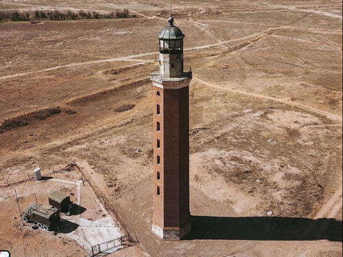
1876 (station established 1761). Inactive for many years, perhaps since 1928 as mentioned by one blogger. 60 m (197 ft) octagonal brick tower with lantern and gallery. The lighthouse is unpainted brick, lantern painted black. Evgeny Vlasov has the 2021 drone view seen at right, Lightphotos.net has a closeup by Andrey Senyushkin, Alexander Belenkiy has an article with many photos inside and outside the tower, Matvey Boronylov has a 2021 photo, Wikimedia has a photo by Alfred Schaerli, Russian Wikipedia has an article with the history of the light station, and Bing has a satellite view. Tsar Peter the Great ordered a lighthouse built here in 1722 to mark the entrance to the Volga River from the Caspian Sea, but there's no solid evidence of a light until a wood tower was built in 1761. We don't know the date of the present lighthouse. Due to falling water levels the lighthouse is now about 25 km (15 mi) from the open waters of the sea, so it no longer has any navigational value. Following the fall of the Soviet Union in 1991 the light station was used as a border guard station; currently it serves as the headquarters of Russia's Caspian coast guard. Located at the south end of the village of Vyshka, on the west side of the Volga delta. Accessible by road from Astrakhan. Site open, tower status unknown. ARLHS ERU-291.

Vyshka Light, Vyshka, December 2021
Google Maps photo by Evgeny Vlasov

Republic of Dagestan Lighthouses
The Republic of Dagestan, the southernmost of the federal subjects (members) of the Russian Federation, has about 400 km (250 mi) of coastline on the northwestern side of the Caspian Sea. Makhachkala (formerly called Petrovsk) is the capital and the major port.
Ostrov Tyuleniy (Seal Island) (2?)
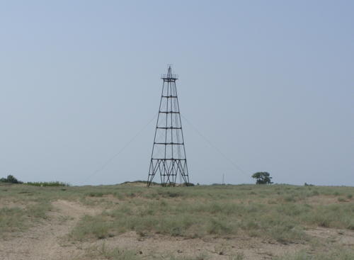
Date unknown. Reported inactive as of 2015. Approx. 28 m (92 ft) square pyramidal skeletal tower. Wikimedia has a photo (also seen at right), Valery Moseykin has a 2015 view from the sea, and Bing has a satellite view. The history of the station is unknown, but this is another location where Peter the Great ordered a lighthouse to be built in 1722. Tyuleniy is an island in the middle of Kizlyarskiy Bay, on the west side of the Caspian Sea about 60 km (40 mi) north of Ostrov Chechen' and 30 km northeast of Cape Suyutkina. The island is known for its wildlife, including birds and the endangered Caspian seal, and it is the site of a meteorological station. A Soviet-era fishing village is abandoned, so there is no permanent population. The lighthouse is located at the west end of the island. Accessible only by boat. Site status unknown. ARLHS ERU-313.
Chechen' (Ostrov Chechen') (2)
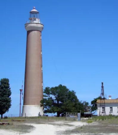
1863 (station established by 1830). Active; focal plane 41 m (135 ft); white light, pattern unknown. 40 m (131 ft) round brick tower with lantern and gallery. The tower appears to be unpainted red brick; lantern painted white with a gray metallic roof. The station includes a 1-story keeper's house and several smaller buildings. Nick Yakovlev's photo appears at the top of this page, Wikimapia has several photos, and Google has a good satellite view of the station. The lighthouse was designed and built by British engineers under contract to the imperial government. Ostrov Chechen' is a large island in the northwestern Caspian Sea about 80 km (50 mi) north of Makhachkala. There are small fishing villages on the island and it was formerly the site of a prison and a leper colony. The light station is located on the sandy western side of the island. Accessible only by boat. Site status unknown. ARLHS ERU-293.

Ostrov Tyuleniy Light, Caspian Sea, 2011
Wikimedia public domain photo by Aksyanov
Sulak
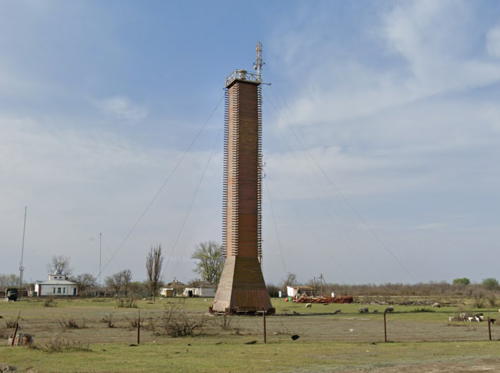
Date unknown. Active; white light, pattern unknown. Approx. 25 m (82 ft) square cylindrical unpainted concrete tower with a pyramidal base, carrying a small lantern. Google has a 2021 street view (also seen at right), a view across the river (1/4 the way down the page) is available, and Google has a satellite view. Sulak is a fishing town with about 8600 residents, but Russian Wikipedia notes that the town's fish processing plant has closed, probably due to declining catches. The Sulak River is the major river draining the majority of Dagestan. Located on the north side of the entrance to the Sulak River, about 50 km (30 mi) north of Makhachkala. Site status unknown.
Makhachkala North Entrance Range Front
Date unknown. Active; focal plane about 20 m (66 ft); green light, pattern unknown. Approx. 14 m (46 ft) skeletal tower carrying a triangular daymark, point down. No photo available but Google has a satellite view. This is the entrance range for the commercial harbor on the north side of Makhachkala. Located on the waterfront at the south end of the harbor. Site status unknown.
Makhachkala North Entrance Range Rear
Date unknown. Active; focal plane perhaps 40 m (131 ft); red light, pattern unknown. Approx. 15 m (49 ft) skeletal tower carrying a triangular daymark, point up. No photo available but Google has a satellite view. Located within the harbor area about 160 m (0.1 mi) south of the front light. Site status unknown.

Sulak Light, Sulak, April 2021
Google Maps street view
* Makhachkala (Petrovsk Port)
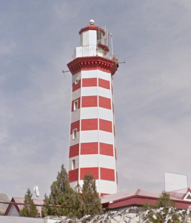
1866 (station established 1852). Active (?); focal plane 84.5 m (277 ft); flashing white light. 27 m (89 ft) octagonal stone tower with lantern and gallery, painted with red and white horizontal bands, rising through a building. A photo is at right, Yuri Baranovsky has a 2019 closeup, Mikhail Koroviev has a 2021 closeup, another photo is available, Huelse has a historic postcard view, and Google has a street view and a satellite view. Navionics charts the tower as an inactive landmark but Russian Wikipedia describes it as active. Makhachkala, the capital of the Republic of Dagestan, is the largest Russian port on the west coast of the Caspian. It has a population of about 600,000 and is an important ferry terminal with rail ferries crossing the Caspian from Makhachkala to Aktau in Kazakhstan. Founded in 1844, it was called Petrovsk Port until 1921. Located on a hill about 500 m (0.3 mi) south southwest of the port area. Site open, tower closed.
Makhachkala Main Entrance Range Front
Date unknown. Active; focal plane about 20 m (66 ft); white light, pattern unknown. Approx. 15 m (49 ft) square skeletal mast supporting a square platform. In the center of a street view from the harbor this tower is between two taller towers, the rear light tower on the left and another tall tower on the right. The slender tower has not been found in Bing's satellite view. Located near the south .end of the main harbor. Site status unknown.
Makhachkala Main Entrance Range Rear
Date unknown. Active; focal plane about 40 m (131 ft); white light, pattern unknown. Approx. 35 m (115 ft) square skeletal mast supporting a square platform. Google has a street view but the slender tower has not been found in Bing's satellite view. Located about 400 m (1/4 mi) southwest of the front light. Site status unknown.
Makhachkala Breakwater (1)
Date unknown. Inactive. Approx. 24 m (79 ft) round cylindrical tower with several galleries and a round harbor control room at the second-floor level. A radar antenna is mounted on an extension of one of the galleries. The tower is painted with multicolored bands: red and white at the top; green, blue and red above the control room. The control room is white with a blue roof. Lightphotos.net has a photo, Wikimapia has a photo, Arsen Buttaev has the view from a nearby beach, and Google has a satellite view. The active light appears to have been moved to a post at the end of an extension of the breakwater. Located at the end of the original breakwater of Makhachkala's Rybnyy harbor. Site status unknown.
Makhachkala Rybnyy Range Front
Date unknown. Active; focal plane about 30 m (98 ft); red light, pattern unknown. 18 m (59 ft) square skeletal tower painted with red and white horizontal bands. A street view from the beach is available and Google has a satellite view. This is the entrance range for the Rybnyy port in downtown Makhachkala. Located beside railroad tracks along the coast about 800 m (1/2 mi) southeast of the front light. Site status unknown.
Makhachkala Light
Makhachkala Light, Makhachkala, September 2005
ex-Panoramio photo copyright Pupsoid; used by permission
Makhachkala Rybnyy Range Rear
Date unknown. Active; focal plane about 20 m (66 ft); red light, pattern unknown. 18 m (59 ft) skeletal mast. Abdulmanap Medzidov has a photo and Google has a satellite view. Located near the foot of the breakwater of the Rybnyy harbor. Site status unknown.
Turalinskiy (Kaspiysk, Mys Turali) (2)
Date unknown. Active; focal plane about 20 m (66 ft); white light, pattern unknown. Approx. 16 m (52 ft) square concrete tower painted with red and white horizontal bands. A photo is available and Google has a satellite view. The photographer writes "Not far from the city was an old beautiful lighthouse, but it was dilapidated and threatened with demolition. I went in search of it, but instead of the lighthouse I found this." In fact Alexey Marakhovets has a 2008 photo of a dilapidated square brick tower, originally painted with red and white horizontal bands. The tentative conclusion is that the old tower collapsed or was removed and the more recent photo shows its replacement. Mys Turali is a point of land just south of the tower. Located just off the beach in Kaspiysk, a seaport about 20 km (13 mi) southeast of Makhachkala. Site status unknown.
Buinakskiy (Mys Buinak)
Date unknown. Active; focal plane about 30 m (98 ft); white light, pattern unknown. Approx. 20 m (66 ft) round cylindrical tower painted with red and white horizontal bands. Google has a street view and a satellite view. Located on the headland of Mys Buinak about 5 km (3 mi) northwest of Izberbash, a town 56 km (35 mi) southeast of Makhachkala. Site status unknown.
* Derbentskiy (Derbent) (2)
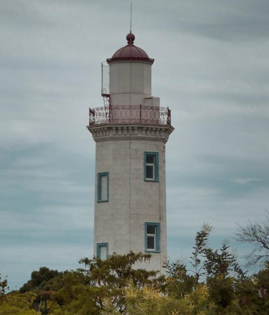
1866 (station established 1853). Active; light characteristic unknown. 18.5 m (61 ft) octagonal stone tower with lantern and gallery. The lighthouse is unpainted white stone; lantern painted white with a red roof. Shamil Magomedov's photo is at right, Maria Leshchinskaya has a 2021 photo, another page for the lighthouse has historical information, and Google has a street view and a satellite view. This is the oldest of the Russian lighthouses on the Caspian Sea. The lighthouse was restored in 2007 and a "bright new light source" was installed. Derbent, not far from the border of Azerbaijan, is the southernmost city in Russia. It is also the oldest city in Russia, dating from around the 8th century BCE. The city's famous walls, known as the Caspian Gates, originally stretched for 40 km (25 mi) from the sea to the Caucasus Mountains. Located in the city, at the southeastern corner of Kirov Park. Site open, tower closed.

Information available on lost lighthouses:

Notable faux lighthouses:


Derbentskiy Light, Derbent, March 2012
Wikipedia Creative Commons photo by Shamil Magomedov

Adjoining pages: North: Volga and Don | East: Kazakhstan | South: Azerbaijan

Return to the Lighthouse Directory index | Ratings key

Posted February 26, 2007. Checked and revised August 2, 2023. Lighthouses: 15; lightships: 1. Site copyright 2023 Russ Rowlett and the University of North Carolina at Chapel Hill.