Lighthouses of Indonesia: Southeastern Kalimantan (Borneo)

The Republic of Indonesia has been independent since 1945 after having been the Dutch East Indies for more than 350 years. It is a huge country, stretching along both sides of the Equator for more than 46 degrees of longitude (roughly 5100 km or 3200 miles). Comprised of some 17,000 islands (more than 6000 inhabited islands), it has hundreds of major aids to navigation.

Borneo, known as Kalimantan in Indonesia, is the world's third largest island. 73% of the island is Indonesian; the remaining portion includes the Malaysian states of Sarawak and Sabah and the independent sultanate of Brunei. Indonesian Kalimantan is separated from Sulawesi (Celebes) to the east by the Makassar Strait, from Java to the south by the Java Sea, and from Sumatra to the southwest by the Karimata Strait and Natuna Sea.

Indonesia is divided into 38 provinces (provinsi) and the provinces are subdivided into county units called regencies (kabupaten). This page describes lighthouses in East Kalimantan Province in the regencies surrounding the major cities of Samarinda and Balikpapan. Lighthouses of Berau Regency in the north of the province are included on the Northeastern Kalimantan page and lighthouses of the Bontang area are on the Eastern Kalimantan page. The coast covered by this page faces Sulawesi (Celebes) across the broad Makassar Strait, a passage 130 to 370 km (80 to 250 mi) wide.

In Indonesian a lighthouse is a mercusuar or a menara suar. Tanjung is a cape, ujung is a headland or point of land, bukit is a hill, sungai is a river, kuala or muara is an estuary or river mouth, pulau is an island, karang is a reef, batu is a rock, laut is a sea, selat is a strait, teluk is a bay, pelabuhan is a harbor, and labuhan is a port.

Aids to navigation in Indonesia are operated and maintained by the Directorate of Marine Navigation within the Directorate General of Sea Transportation

ARLHS numbers are from the ARLHS World List of Lights. Admiralty numbers are from volumes F and Q of the Admiralty List of Lights & Fog Signals. U.S. NGA List numbers are from Publication 112.

General Sources
Online List of Lights - Indonesia
Photos by various photographers posted by Alexander Trabas.
Indonesian Lighthouses
Historic postcard views from the collection of Michel Forand.
World of Lighthouses - Indonesia
Photos by various photographers available from Lightphotos.net.
GPSNauticalCharts
Navigational chart information for eastern Kalimantan.
Kalimantan Timur Map
A useful map of eastern Kalimantan.
Navionics Charts
Navigation chart for eastern Kalimantan.

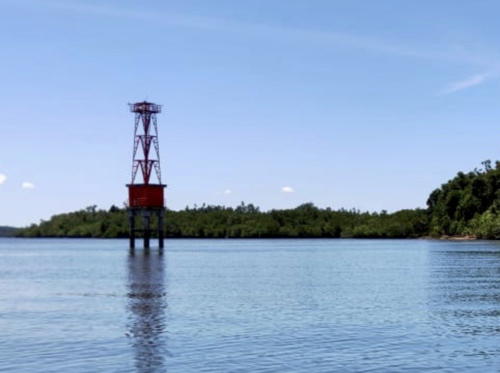
Tanjung Tamarong Light, Kutai Kartanegara, April 2022
Google Maps photo by Satria Handrianto
Kutai Kartanegara Regency and Samarinda City Lighthouses
The Mahakam River is the third longest river of Borneo and an important artery of commerce. The river has formed a broad, fan-shaped delta where it flows into the Makassar Strait. There are several navigable distributaries, the most imporant being the Muara Pegah on the south side of the delta. In the Admiralty listings the river is called the Kutei River (Sungai Kutei).
Muara Berau (Tanjung Panjilatan)
Date unknown. Active; focal plane 14 m (46 ft); white light, 2 s on, 8 s off. 14 m (46 ft) square white skeletal tower on a platform supported by piles. Ibr Koet has a very distant view and Google has a satellite view. Located on the west side of the entrance to the northernmost distributary of the Mahakam River. Accessible only by boat. Admiralty Q1468.5; NGA 24882.
Mahakam River
Date unknown. Active; focal plane about 12 m (39 ft); white light, pattern unknown. Approx. 12 m (39 ft) skeletal tower on a platform supported by piles. No photo available but Google has a satellite view. Located on the south side of the river marking a sharp bend about 25 km (15 mi) southeast of the mouth. Accessible only by boat. Admiralty Q1468.77.
Samarinda
2018. Active; focal plane about 27 m (92 ft); white light, pattern unknown. Approx. 25 m (82 ft) square white skeletal tower. Salman Lanang has a 2021 photo, a 2019 photo is available, and Google has a satellite view and the 2022 street view seen at right. The capital of East Kalimantan Province, Samarinda is a large city with a population of more than 800,000. The city straddles the Mahakam River above the delta and about 50 km (30 mi) from the sea. The lighthouse is located at the district navigation headquarters on the north bank a short distance east of the city's ferry terminal. Site status unknown. Admiralty Q1463.12.
Tanjung Tamarong
2007. Active; focal plane 33 m (180 ft); white light, 2 s on, 8 s off. 30 m (98 ft) "white tower." Satria Handrianto's 2022 photo is at the top of this page but the tower is not seen in Bing's satellite view. Tanjung Tamarong is the easternmost point of the Mahakam River delta. Located about 2.5 km (1.5 mi) east of the cape, in which case it is accessible only by boat. Site open, tower closed. Admiralty Q1468.46; NGA 24881.
Tanjung Kayumajarang (Muara Bayur)
Date unknown. Active; focal plane 19 m (62 ft); three white flashes evry 15 s. This light is on a tall communications tower mounted on an offshore loading port just off the Mahakam river delta. No photo available but Bing has a satellite view. Accessible only by boat. Site status unknown. Admiralty Q1468.25; NGA 24859.
Tanjung Bayur (Bayor)
Date unknown. Active; focal plane 14 m (46 ft); four white flashes every 20 s. 14 m (46 ft) skeletal tower on a platform supported by piles. No photo available and the light is not shown in Google's satellite view. Located about 8 km (5 mi) off Tanjung Bayur, marking the entrance to Muara Bayur, one of the central distributaries of the Mahakam River. Accessible only by boat. Site status unknown. Admiralty Q1468.05; NGA 24858.

Samarinda Light, Samarinda, June 2022
Google Maps street view
Muara Pegah Outbound Range (Range No. 1) Rear
Date unknown. Active; focal plane 16 m (52 ft); white light, 2 s on, 2 s off. 16 m (52 ft) white skeletal tower on a platform supported by piles. No photo available and the light is not shown in Google's satellite view. The range guides departing ships on the last long reach down the Pegah Estuary, a southern distributary of the Mahakam River. The front light is on a 10 m (33 ft) tower. Located about 11 km (7 mi) south of the mouth of the estuary. Accessible only by boat. Site open, tower closed. Admiralty Q1462.21; NGA 24844.
Muara Pegah Approach/Outbound Range (Range No. 2) Common Rear
Date unknown. Active; focal plane 15 m (49 ft); white light, 1 s on, 1 s off. 15 m (49 ft) white skeletal tower on a platform supported by piles. No photo available and the light is not shown in Google's satellite view. This is the common rear light for both the approach range and an outbound range. The front lights are on short towers. Accessible only by boat. Site open, tower closed. Admiralty Q1462.4; NGA 24836.
Muara Pegah Range Front
Date unknown. Active; focal plane about 12 m (39 ft); white light, pattern unknown. Approx. 12 m (39 ft) square white skeletal tower on a platform supported by piles. No photo available but Google has a satellite view. This is the entrance range for for the Pegah Estuary Located about 2 km (1.25 mi) south of the Bukuan lighthouse. Accessible only by boat. Site open, tower closed. Admiralty Q1461.93.
Muara Pegah Range Rear
Date unknown. Active; focal plane about 25 m (82 ft); white light, pattern unknown. Approx. 25 m (82 ft) square white skeletal tower on a platform supported by piles. No photo available but Google has a satellite view. Located about 1.2 km (3/4 mi) north of the front light. Accessible only by boat. Site open, tower closed. Admiralty Q1461.95.
Bukuan (Muara Pegah, Pulau Bukuan, Bukuan Island)
Date unknown. Active; focal plane 41 m (135 ft); white flash every 15 s. Approx. 40 m (131 ft) skeletal tower with lantern and gallery, painted white. A 2016 photo (also seen at right) is available, Efendi Gultom has a distant 2023 view from the river, and Google has a satellite view. Located on an island at the south end of the delta of the Mahakam River, Site status unknown. ARLHS IDO-119; Admiralty Q1462; NGA 24846.

Pulau Bukuan Light, Samarinda, February 2016
ex-Google Plus photo by VTS Samarinda
Tanjung Nibung Range Front
Date unknown. Active; focal plane about 12 m (39 ft); white light, pattern unknown. Approx. 12 m (39 ft) square white skeletal tower on a platform supported by piles. No photo available but Google has a satellite view. The range guides ships northward in the Pegah distributary. Located on the west side of the Pegah at a sharp bend. Accessible only by boat. Site open, tower closed. Admiralty Q1462.5.
Tanjung Nibung Range Rear
Date unknown. Active; focal plane about 18 m (59 ft); white light, pattern unknown. Approx. 18 m (59 ft) square white skeletal tower on a platform supported by piles. No photo available but Google has an indistinct satellite view. Located on the east bank of the Pegah about 700 m (0.43 mi) north of the front light. Accessible only by boat. Site open, tower closed. Admiralty Q1462.51.
Muara Jawa Range (No. 4) Rear
Date unknown. Active; focal plane 12 m (39 ft); white light, 2 s on, 2 s off. 12 m (39 ft) square white skeletal tower on a platform supported by piles. The light is barely visible in the center of Yon Rizal's view across the river and Google has a satellite view. The front light is on a similar 7 m (23 ft) tower 80 m (260 ft) south; it is also visible in Rizal's photo. Located on the east bank of the Pegah distributary across from an industrial facility, the Ranji Karya Sakti - Kutai Petroleum Logistic Base. Accessible only by boat. Site open, tower closed. Admiralty Q1462.81; NGA 24864.
Senipah (Sepinggang) Entrance North
Date unknown. Active; focal plane 10 m (33 ft); green flash every 2 s. 10 m (33 ft) square skeletal tower on a platform supported by piles. No photo available but Bing has an indistinct satellite view. These two lights guides ships to a dock of the Pentamina Hulu oil and gas company. Located about 1.5 km (1 mi) offshore and 13 km (8 mi) southwest of the Pegah entrance. Accessible only by boat. Site open, tower closed. Admiralty Q1459.95; NGA 24848.
Senipah (Sepinggang) Entrance South
Date unknown. Active; focal plane 10 m (33 ft); quick-flashing red light. 10 m (33 ft) square skeletal tower on a platform supported by piles. No photo available but Bing has an indistinct satellite view. Located about 1.5 km (1 mi) offshore and 13 km (8 mi) southwest of the Pegah entrance. Accessible only by boat. Site open, tower closed. Admiralty Q1459.94; NGA 24847.
Ambarawang (Tanjung Tanahmerah)
2019 (?). Active; focal plane 32 m (105 ft); two white flashes every 10 s. 30 m (98 ft0 square white skeletal tower. A distant 2024 view is available, the tower is seen near the end of a 30-second YouTube video, and Google has a satellite view. Located at a new port being developed at Ambarawang, about 50 km (30 mi) southwest of the Pegah entrance. Site open, tower closed. Admiralty Q1459.83.

Balikpapan City Lighthouses
Balikpapan is a large city, having more than 700,000 residents; it is the center for oil production in eastern Kalimantan. It was captured by the Japanese early in World War II and retaken by Allied troops in very heavy fighting in July 1945, one of the last battles of the war.

*
Tanjung Manggar
Date unknown. Active; focal plane 43 m (141 ft); three white flashes every 21 s. 40 m (131 ft) square skeletal tower with lantern and gallery; tower painted white, lantern red. Jaya Frana has the 2018 photo seen at right and Google has a street view and a satellite view of the station. Located at a regional office of the sea navigation directorate, on a minor cape about 20 km (13 mi) northeast of Balikpapan. Site open, tower closed. ARLHS IDO-313; Admiralty Q1459.8; NGA 24918.
 

Tanjung Manggar Light, Balikpapan, September 2018
Google Maps photo by Jaya Frana
 
Balikpapan Approach Range Rear (No. 2)
Date unknown. Active; focal plane 15 m (49 ft); white light, 2.5 s on, 2.5 s off. 15 m (49 ft) square skeletal tower painted white. No photo available and the tower does not appear in Google's satellite view. The front light (No. 1) is on a much shorter tower. Located about 3 km (2 mi) off the beach southeast of Balikpapan. Accessible only by boat. Site open, tower closed. Admiralty Q1459.21; NGA 24892.
Balikpapan Outbound Range Rear (No. 6)
Date unknown. Active; focal plane 18 m (59 ft); white light, 2 s on, 2 s off. 18 m (59 ft) square skeletal tower painted white. No photo available and the tower does not appear in Bing's satellite view. The front light (No. 5) is on a much shorter tower. Located 1000 m south southeast of the front light. Accessible only by boat. Site open, tower closed. Admiralty Q1459.61; NGA 24912.
Balikpapan Common Range Rear (No. 4)
Date unknown. Active; focal plane 25 m (82 ft); quick-flashing white light. 25 m (82 ft) square skeletal tower painted white. No photo available and the tower does not appear in Bing's satellite view. This light is the rear light for an outbound range with No. 7 as the front light and for an inbound range with a much smaller front light (no. 3). Located about 1.1 km (0.7 mi) south of the No. 7 Light. Accessible only by boat. Site open, tower closed. Admiralty Q1459.41; NGA 24904.
Balikpapan Outbound Range Front (No. 7)
Date unknown. Active; focal plane 16 m (52 ft); quick-flashing white light. 16 m (52 ft) square skeletal tower painted white. No photo available and the tower does not appear in Bing's satellite view. Located about 5 km (3 mi) off Panajam in the northwestern corner of Balikpapan Bay. Accessible only by boat. Site open, tower closed. Admiralty Q1459.42; NGA 24896.
Balikpapan (Tanjung Tokong, Tukong Hill) (3?)
Date unknown. Active; focal plane 93 m (305 ft); one long white flash every 20 s. 30 m (98 ft) square skeletal tower with a large octagonal gallery, painted white. Garry Welly's 2024 photo is at right, and Google has a satellite view. The extra large gallery was added sometime in 2021-22; Johan Wydiamarta Damping's 2020 photo shows the earlier appearance of the tower. A 2010 photo shows that the light was previously painted with red and white horizontal bands. Forand has a historic postcard view said to be of an earlier lighthouse, but light lists do not describe such a tower. In fact, no references are known to any Balikpapan lighthouse prior to World War II. NGA describes an 8 m (26 ft) "white building," a light known to have been in place at least by 1955. Located atop a steep hill on the east side of the entrance to Balikpapan's harbor. Site status unknown. ARLHS IDO-362; Admiralty Q1459; NGA 24920.

Tanjung Tokong Light, Balikpapan, May 2024
Google Maps photo by Garry Welly
Kampung Baru
Date unknown. Active; focal plane 15 m (49 ft); green flash every 5 s. 15 m (49 ft) round green barbell-shaped tower on a platform supported by piles. Adang Thea has the 2020 photo seen at right, Dirham Alif has a photo, and Google has a satellite view. Located just off the waterfront of Kampung Baru, a port area on the north side of downtown Balikpapan. Accessible only by boat. Admiralty Q1459.719.
Baruujung South
Date unknown. Active; focal plane 15 m (49 ft); two green flashes every 4 s. 14 m (46 ft) green tower. No photo available but Bing has an indistinct satellite view. Located on the east side of the channel of the Wain Besar River northwest of downtown Balikpapan. Accessible only by boat. Site open, tower closed. Admiralty Q1459.72.
Baruujung Southwest
Date unknown. Active; focal plane 15 m (49 ft);red light, pattern unknown. 14 m (46 ft) red tower. No photo available but Bing has an indistinct satellite view. Located on the west side of the channel of the Wain Besar River opposite the Baruujung South light. Accessible only by boat. Site open, tower closed. Charted by Navionics but not listed by the Admiralty.
Baruujung East
Date unknown. Active; focal plane 15 m (49 ft); continuous green light. 15 m (49 ft) square green skeletal tower on a platform supported by piles. A 2024 photo and a closeup are available and Bing has an indistinct satellite view. Located on the east side of the channel of the Wain Besar River about 1000 m (0.6 mi) northeast of the Baruujung South light. Accessible only by boat. Site open, tower closed.Admiralty Q1459.722.
Baruujung West
Date unknown. Active; focal plane 15 m (49 ft); red flash every 4 s. 15 m (49 ft) square red skeletal tower on a platform supported by piles. No photo available but Bing has an indistinct satellite view. Located on the west side of the channel of the Wain Besar River opposite the Baruujung East light. Accessible only by boat. Site open, tower closed. Admiralty Q1459.723.

Kambung Buru Light, Balikpapan, July 2020
Google Maps photo by Adang Thea
Tanjung Makasar (Tanjung Batu)
Date unknown. Active; focal plane 15 m (49 ft); green flash every 5 s. 15 m (49 ft) green barbell-shaped tower on a platform supported by piles. A2022 photo is available and Google has a satellite view. Located off the PTK oil company's base on Tanjung Batu, a low point on the east side of the Balikpapan River. Accessible only by boat. Site open, tower closed. Admiralty Q1459.73; NGA 24923.
Karingau Terminal
2017. Active; focal plane about 30 m (98 ft); light characteristic unknown. Approx. 25 m (82 ft) square white skeletal tower. Google has a street view and a satellite view. Located at the Karingau Container Terminal in North Balikpapan. Site and tower closed. Admiralty Q1459.765.

Penajam Paser Utara (North Penajam Pasar) Regency Lighthouses
These lights are on the Balikpapan River upstream (north) of Balikpapan.

Pelabuhan Mentawir
Date unknown. Active; focal plane about 16 m (52 ft); flashing white light. Approx. 16 m (52 ft) square white skeletal tower. The tower is in the center of a distant view by Sasmita Nugroho. Google has a satellite view. Located just offshore at a coal terminal near Mentawir on the east side of the Balikpapan River about 65 km (40 mi) north of Balikpapan. Site status unknown. Admirakty Q1459.798.
Pelabuhan Cita Sabut
Date unknown. Active; focal plane about 16 m (52 ft); light characteristic not listed. Approx. 15 m (49 ft) square white skeletal tower. The light is at the lower left in a photo of the area and on the quay at right in Golmar Silaban's drone view, and Google has a satellite view. This light probably replaced another tower seen at lower center in the photo. Located at a timber terminal on a tributary of the Balikpapan River about 65 km (40 mi) north of Balikpapan. Site status unknown. Admiralty Q1459.7965.
Pulau Balang (2)
Date unknown. Active; focal plane about 16 m (52 ft); white flash every 5 s. Approx. 16 m square red skeletal tower atop a square equipment building and mounted on a platform supported by piles. The Admiralty describes a 12 m (39 ft) white tower. Teah Suta has a 2022 photo at right and Google has a satellite view. Pulau Balang is a large island in the Balikpapan River about 30 km (19 mi) north of Balikpapan. The Balang Island Bridge, completed in 2020, crosses the island and the river. The lighthouse is located a short distance south of the bridge. Accessible only by boat but visible from the bridge. Site open, tower closed. Admiralty Q1459.795.
Lango Tanjung Gosong
Date unknown. Active; focal plane 12 m (39 ft); red flash every 5 s. 12 m (39 ft) red barbell-shaped tower on a platform supported by piles. No photo available but Google has an indistinct satellite view. Located on the west side of the channel in the Balikpapan River opposite the Kariangau Terminals about 16 km (10 mi) north of Balikpapan. Accessible only by boat. Admiralty Q1459.768.
Tanjung Jenebora
Date unknown. Active; focal plane 16 m (52 ft); red flash every 4 s. 16 m (52 ft) red barbell-shaped tower. No photo available but Google has an indistinct satellite view. Located on a shoal off Jenebora on the west side of the channel in the Balikpapan River north of Balikpapan. Accessible only by boat. Site open, tower closed. Admiralty Q1459.76; NGA 24922.

Pulau Balang Light, Balikpapan, February 2022
Google Maps photo by Teah Suta

Pasar Regency Lighthouses
Tanjung Maruat
Date unknown. Active; focal plane 16 m (52 ft); white flash every 10 s. 16 m (52 ft) white skeletal tower on a square platform. No photo available and the light is not shown in Google's satellite view of the area. Located on a shoal off a cape on the north side of the entrance to Adang Bay about 80 km (50 mi) southwest of Balikpapan. Accessible only by boat. Site status unknown. Admiralty Q1458; NGA 24923.7.
Teluk Adang Range Front
Date unknown. Active; focal plane about 13 m (43 ft); light characteristics unknown. Approx. 13 m (43 ft) square white skeletal tower on a square platform supported by piles. Bayu Pratama has a 2022 photo of the range lights and Google has a satellite view. The range guides ships to Pondong, a small port at the head of Adang Bay. Located a shirt distance northeast of the Pondong piers. Accessible only by boat. Site open, tower closed. Admiralty Q1456.2.
Teluk Adang Range Rear
Date unknown. Active; focal plane about 18 m (59 ft); light characteristics unknown. Approx. 18 m (59 ft) square white skeletal tower on a square platform supported by piles. Bayu Pratama has a 2022 photo of the range lights and Google has a satellite view. Located about 280 m (300 yd) southwest of the front light. Accessible only by boat. Site open, tower closed. Admiralty Q1456.21.
Teluk Adang
Date unknown. Active; focal plane 15 m (49 ft); white flash every 4 s. 15 m (49 ft) white skeletal tower on a square platform. No photo available, and the light is not shown in Bing's satellite view of the area. Located on a shoal off the cape on the south side of the entrance to Adang Bay. Accessible only by boat. Site status unknown. Admiralty Q1456; NGA 24924.
Karang Karanagan
Date unknown. Active; focal plane 15 m (49 ft); three white flashes every 15 s. 15 m (49 ft) tower painted black with one red horizontal band and mounted on a platform supported by piles. No photo available and the light is not shown in Google's satellite view. Located on a shoal about 25 km (15 mi) southeast of the Adang Bay entrance. Accessible only by boat. Site open, tower closed. Admiralty Q1457.5; NGA 24926.
Teluk Apar
Date unknown. Active; focal plane 15 m (49 ft); white flash every 4 s. 15 m (49 ft) red skeletal tower on a square platform. No photo available, and the light is not shown in Bing's satellite view of the area. Located on a shoal off the entrance to Apar Bay about 35 km (22 mi) south of Teluk Adang. Accessible only by boat. Site status unknown. Admiralty Q1455; NGA 24928.
Tanjung Giling
Date unknown. Active; focal plane 16 m (52 ft); green flash every 7.5 s. 16 m (52 ft) green skeletal tower on a square platform. No photo available, and the light is not shown in Bing's satellite view of the area. Located about 1.6 km (1 mi) off Tanjung Giling, the cape on the north side of the entrance to Apar Bay. Accessible only by boat. Site status unknown. Admiralty Q1457; NGA 24929.
Gosong Aru (Aru Bank)
Date unknown (station established 1901). Active; focal plane 13 m (43 ft); three quick white flashes every 10 s. 13 m (43 ft) skeletal tower mounted on a platform supported by piles. No photo available and the light is not shown in Google's fuzzy satellite view. This is the oldest offshore light station in the Makassar Strait. Located on a notorious shoal about 130 km (80 mi) south of Balikpapan. Accessible only by boat. Site open, tower closed. ARLHS IDO-364; Admiralty Q1454; NGA 24932.

Information available on lost lighthouses:

Notable faux lighthouses:

Adjoining pages: North: Eastern Kalimantan | Northeast: Northern Sulawesi | East: Western Sulawesi | South: South Kalimantan

Return to the Lighthouse Directory index | Ratings key

Posted December 9, 2008. Checked and revised May 15, 2024. Lighthouses: 42. Site copyright 2024 Russ Rowlett and the University of North Carolina at Chapel Hill.